Email signup
A storm-related power outage in Great Falls on June 27, 2023 (via Dominion Energy)

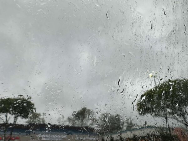
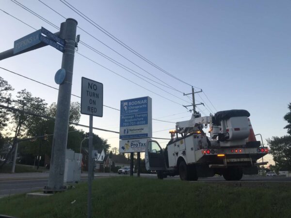
After failing to materialize yesterday, stormy weather showed up in force around the D.C. region this afternoon (Tuesday).

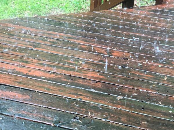
A Severe Thunderstorm Warning was issued for Fairfax County and the rest of the area for around 2:11-3 p.m. The National Weather Service reported that the east-moving storm had reached the Oakton and Vienna area around 2:09 p.m., bringing 60-mph wind gusts and hail the size of quarters, according to Fairfax County.

“Damaging winds will cause some trees and large branches to fall,” the county’s emergency information blog said. “This could injure those outdoors, as well as damage homes and vehicles. Roadways may become blocked by downed trees. Localized power outages are possible. Unsecured light objects may become projectiles.”

As of 3 p.m., about 2,826 people in Fairfax County and Fairfax City have lost power, according to Dominion Energy.

Per the utility company’s outage map, the largest individual outages appear to be along Fairfax Blvd, where 914 customers are without power, and in Great Falls, where 509 customers are affected.

The Fairfax outage stems from an out circuit and is expected to be restored between 5-8 p.m. Dominion estimates a restoration time of 6-9 p.m. for the Great Falls outage, which is directly attributed to the storm.

In Tysons, downed trees were reportedly blocking the ramp from eastbound Route 7 (Leesburg Pike) to northbound Route 123 (Chain Bridge Road), according to the NWS.

Hail was confirmed in Reston by resident Robyn Matthews, but the storm moved relatively quickly, prompting the NWS to let the warning expire on time at 3 p.m.

“The storm which prompted the warning has weakened below severe limits, and no longer poses an immediate threat to life or property,” a 2:51 p.m. update said. “Therefore, the warning will be allowed to expire. However gusty winds and heavy rain are still possible with this thunderstorm.”

0 Comments
Rain on a car window (staff photo by Angela Woolsey)

Some pretty gnarly weather is bearing down on Fairfax County and the rest of the D.C. area.

The National Weather Service has issued a Severe Thunderstorm Watch for the region until 9 p.m.

A Hazardous Weather Outlook issued earlier that could last until midnight forecast heavy storms with the worst impact expected to be east of I-81, including Fairfax County, where the likelihood of severe weather is considered “moderate.”

“Damaging wind gusts and large hail are the primary threats along with the possibility of a brief tornado,” Fairfax County said in a blog post sharing the NWS alert. “Additionally, there is a threat for flash flooding across the entire outlook area this afternoon and evening.”

According to the Virginia Department of Transportation, the region along and east of I-95 could see wind gusts of “up to 75 mph, large hail and possible isolated tornadoes.”

The department is advising travelers to pay close attention to weather reports and to potential limit travel as conditions evolve, warning that the storm could take down trees and power lines and result in flooding.

“Whenever severe weather is expected, we partner with the Virginia Department of Emergency Management and Virginia State Police to coordinate efforts,” VDOT Commissioner Stephen C. Brich said. “Teams throughout the Commonwealth are prepared to address impacts from this storm. We ask for the public’s assistance to remain safe and stay aware of changing weather and road conditions in their area and along their travel routes.”

The storms are moving to the East Coast from the Midwest, which were hit by hail ranging from the size of a baseball to a grapefruit yesterday (Sunday), according to the Capital Weather Gang. Tornadoes have reportedly damaged dozens of homes and killed at least one person in Indiana.

Here’s more advice on navigating the upcoming weather from VDOT:

Obey all “road closed” signage.

“Turn around, don’t drown” – Do not attempt to travel through flooded roadways. According to the Centers for Disease Control, the primary causes of flood-related deaths occur to individuals driving into or walking in or near flood waters.

  • 6 inches of flood water is enough to knock an adult off of their feet
  • 12 inches can move most cars
  • 18-24 inches can carry away most large SUVs, vans and trucks

Be alert to debris, downed trees and power lines

Move over for emergency crews operating in or near roadways

Be alert to High Wind Advisories, especially on bridges or taller structures. High-profile vehicles such as tractor trailers, SUVs or box trucks are especially vulnerable and should not cross a bridge when a High Wind Advisory is posted.

0 Comments
Lightning (via Breno Machado/Unsplash)

Fairfax County is under a Severe Thunderstorm Watch and Flood Watch as storms are expected in the region this evening.

The National Weather Service issued the watches this afternoon. They both expire at 10 p.m.

Rainfall could cause flash flooding in the area, according to the Flood Watch.

“Strong to severe thunderstorms will move across the region late this afternoon through the evening hours,” the Flood Watch says. “Heavy rain will accompany a number of these storms which may drop 1 to 2 inches of rainfall in an hour.”

A Hazardous Weather Outlook for the area also says the primary threats are wind gusts and large hail, with the possibility of an isolated tornado.

The full Flood Watch is below.

Event: Flood Watch
Alert:
…FLOOD WATCH REMAINS IN EFFECT UNTIL MIDNIGHT EDT TONIGHT…

* WHAT…Flash flooding caused by excessive rainfall continues to be possible.

* WHERE…Portions of DC, Maryland and northern Virginia, including the following areas: in DC, District of Columbia. In Maryland, Anne Arundel, Calvert, Central and Southeast Howard, Central and Southeast Montgomery, Charles, Northern Baltimore, Northwest Howard, Northwest Montgomery, Prince Georges, Southern Baltimore and St. Marys. In northern Virginia, Arlington/Falls Church/Alexandria, Fairfax, King George, Prince William/Manassas/Manassas Park and Stafford.

* WHEN…Until Midnight EDT tonight.

* IMPACTS…Excessive runoff may result in flooding of rivers, creeks, streams, and other low-lying and flood-prone locations. Creeks and streams may rise out of their banks.

* ADDITIONAL DETAILS…
– Strong to severe thunderstorms will move across the region late this afternoon through the evening hours. Heavy rain will accompany a number of these storms which may drop 1 to 2
inches of rainfall in an hour. Additionally, some regions could see repeat thunderstorm activity leading to an enhanced threat for flooding.
– http://www.weather.gov/safety/flood
Instructions: You should monitor later forecasts and be prepared to take action should Flash Flood Warnings be issued.

Photo via Breno Machado/Unsplash

0 Comments
Lightning (via Breno Machado/Unsplash)

Updated at 6:50 p.m. — The Severe Thunderstorm Watch was canceled at 6:41 p.m., according to a National Weather Service alert.

Earlier: Fairfax County is under a Severe Thunderstorm Watch, and part of the county is also under a Severe Thunderstorm Warning.

The county is under a severe thunderstorm watch until midnight, according to the National Weather Service. There’s also a severe thunderstorm warning for west central Fairfax County, including Burke and Chantilly, until 6:15 p.m.

“Damaging winds will cause some trees and large branches to fall,” the warning reads. “This could injure those outdoors, as well as damage homes and vehicles. Roadways may become blocked by downed trees. Localized power outages are possible. Unsecured light objects may become projectiles.”

The watch was issued at 5:11 p.m. Ready Fairfax said to expect damaging winds and large hail. Isolated tornadoes are possible.

The full watch is below.

Event:
Severe Thunderstorm Watch
Alert:
SEVERE THUNDERSTORM WATCH 378 REMAINS VALID UNTIL MIDNIGHT EDT
TONIGHT FOR THE FOLLOWING AREAS
IN VIRGINIA THIS WATCH INCLUDES 22 COUNTIES
IN CENTRAL VIRGINIA
ALBEMARLE CITY OF CHARLOTTESVILLE
CITY OF FREDERICKSBURG GREENE
KING GEORGE NELSON ORANGE
SPOTSYLVANIA
IN NORTHERN VIRGINIA
ARLINGTON CITY OF ALEXANDRIA CITY OF FAIRFAX
CITY OF FALLS CHURCH CITY OF MANASSAS
CITY OF MANASSAS PARK CULPEPER
FAIRFAX FAUQUIER LOUDOUN
PRINCE WILLIAM STAFFORD
IN NORTHWEST VIRGINIA
MADISON RAPPAHANNOCK
THIS INCLUDES THE CITIES OF ALEXANDRIA, ARLINGTON, CHANTILLY,
CHARLOTTESVILLE, CROZET, CULPEPER, DAHLGREN, FAIRFAX,
FALLS CHURCH, FALMOUTH, FREDERICKSBURG, GORDONSVILLE, GREENFIELD,
HERNDON, LEESBURG, MADISON, MANASSAS, MANASSAS PARK, MCLEAN,
ORANGE, RESTON, SPOTSYLVANIA COURTHOUSE, STANARDSVILLE, STERLING,
WARRENTON, WASHINGTON, AND WOODBRIDGE.
Instructions:

Target Area:
Albemarle
Arlington
City of Alexandria
City of Charlottesville
City of Fairfax
City of Falls Church
City of Fredericksburg
City of Manassas
City of Manassas Park
Culpeper
Fairfax
Fauquier
Greene
King George
Loudoun
Madison
Nelson
Orange
Prince William
Rappahannock
Spotsylvania
Stafford

Photo via Breno Machado/Unsplash

0 Comments
Rain with hail in Vienna (staff photo by Angela Woolsey)

Updated at 7:25 p.m. — A Flood Warning has now been issued for Fairfax County, with an additional half to 1.5 inches of rain possible until 1:15 a.m. Monday. The Severe Thunderstorm Warning has also been extended to 8 p.m.

Earlier: A Severe Thunderstorm Warning is in effect for Fairfax County.

The National Weather Service issued the alert shortly after 5 p.m., warning of 60 mph wind gusts and quarter-sized hail:

IMPACT…Damaging winds will cause some trees and large branches to fall. This could injure those outdoors, as well as damage homes and vehicles. Roadways may become blocked by downed trees. Localized power outages are possible. Unsecured light objects may become projectiles.

Moving eastward, the storm has already made its way through Herndon and just passed the Town of Vienna, bringing a couple minutes of intense rain, thunder, and hail that ended as quickly as it began.

This is the second thunderstorm with hail to hit the D.C. area within the past week, and it came a day after temperatures hit a high of 92 degrees, according to NWS data.

While the warning is set to end at 6 p.m., a Severe Thunderstorm Watch is currently in effect until 9 p.m.

0 Comments
A Virginia Department of Transportation truck in Groveton after a May 16, 2022, storm (staff photo by Brandi Bottalico)

(Updated at 1:45 p.m.) Hundreds of people in Fairfax County are still without power after a thunderstorm swept through the D.C. area late yesterday afternoon (Monday).

Outages have been significantly reduced overnight, with the number of people affected dropping from more than 8,000 to about 500, as of 9:30 a.m., according to PowerOutage.US.

In terms of power losses, the storm primarily affected the south part of the county. Dominion Energy’s outage map indicates that 329 customers in West Springfield and over 50 customers in Hybla Valley, Mount Vernon, and Mason Neck are still waiting for their electricity to return.

Likely the result of fallen trees and branches on power lines, the individual outages appear to be limited in scope, each affecting only a few properties. The estimated time of restoration ranges from 1 to 7 p.m. today (Tuesday).

Yesterday’s storm brought 0.42 inches of precipitation to the Dulles Airport area and 0.27 inches to the National side of the region, according to preliminary climate reports from the National Weather Service.

However, the storm also had an unusual twist in the form of hail. Stones about the size of a quarter were spotted throughout the southeastern part of the county, including Franconia, Rose Hill, Fort Hunt, and Mount Vernon.

Maryland residents reported even larger hailstones.

According to the National Weather Service in Sterling, some hail is not especially unusual for this time of the year, but hail of the size seen yesterday is more rare.

“This is the time of year when we start to really warm up consistently. The caveat is that the atmosphere many thousand feet up is still cold as it takes more time to warm up further up at this point,” NWS meterologist Austin Mansfield said by email. “With lower freezing levels (0°C of the air temperature) in the atmosphere during this time of year but warmer and more unstable air masses looming, we can certainly see hail during this time of year.”

The NWS only tracks hail that’s 0.75 inches or larger in its archives. The last time the agency reported large hail in Fairfax County in May was on May 14, 2018, when it recorded hail with a 1.75-inch diameter, or roughly the size of a golf ball.

“Take that with a grain of salt because we are almost certain that hail has fallen in Fairfax County in the middle of May since then but it was more than likely smaller size (dime/nickel/pea),” Mansfield said.

Other scenes from the storm included fallen branches, waterborne trash cans, and post-rain goslings in Reston.

0 Comments
×

Subscribe to our mailing list