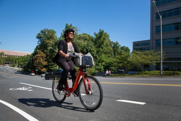
Email signup
Safety and operational improvements are planned for the GW Parkway’s southern segment and Mount Vernon Trail improvements project scope (via National Park Service)

A stretch of the George Washington Memorial Parkway in southern Fairfax County is moving toward some major changes, as is the neighboring Mount Vernon Trail.

The National Park Service, which maintains the GW Parkway and much of the Mount Vernon Trail, plans to start “initial design work and planning for key aspects of the project” this year, per a Jan. 26 press release.

The announcement came after the Environmental Protection Agency released an assessment finding no significant environmental effects from the proposed changes, which will include a road diet and intersection and trail upgrades.

Once work is done, the parkway will be reduced to one southbound travel lane between Mount Vernon and Belle View Boulevard and one northbound lane between Mount Vernon and Tulane Drive. The Mount Vernon Trail, which is typically 8 or 9 feet wide right now, will be expanded to 10 or 12 feet wide in certain areas.

“The primary goal of the project is to enhance safety and reliability for users of the parkway and trail, while preserving the area’s scenic and historic character,” the NPS said. “As vital routes for both local and visiting cyclists, pedestrians, and drivers, these improvements are crucial for the continued enjoyment and safety of everyone who uses these routes.”

The affected portion of the GW Parkway covers about 8.5 miles from George Washington’s Mount Vernon estate (3200 Mount Vernon Memorial Highway) up to the Hunting Creek Bridge south of Alexandria City. According to the NPS, neither the south section of the Parkway nor its drainage systems has had a “comprehensive rehabilitation” since it was constructed in 1932.

Other changes will include a replacement of road surface that the NPS characterizes as “deteriorated” and improvements to drainage and stormwater management.

On the portion of the roadway with a road diet, the plan is to set up two right-hand shoulders or, at southbound intersections, right-turn lanes. Plus, the road will feature a new striped median or center turn lane.

A number of intersections will also see updates intended to make them safer, including the ones with Vernon View Drive, Waynewood Blvd and the access to Tulane Drive, Belle View Blvd and Morningside Lane. A study of crashes on GW Parkway in 2005-2015 and 2018-2019 revealed crashes were most severe at intersections with those roadways, mostly due to vehicle speeds.

Select intersections will also get crosswalks.

The NPS-administered portions of the Mount Vernon Trail will also see stormwater management improvements. Four trail bridges will be replaced, and repairs are planned for 29 more.

The planned trail widening comes nearly four years after NPS finished a study that determined the trail is “relatively narrow by modern standards.”

A full construction schedule and traffic management plan will come after initial design work and planning, but NPS documents indicate that the trail will remain usable to pedestrians and cyclists during construction. Closed sections will be serviced by alternate routes and temporary detours.

The affected section of the GW Parkway may see temporary lane closures, and access to its “recreational, natural, and cultural areas” may be restricted during construction, per the environmental assessment for the project.

0 Comments
A Potomac Heritage National Scenic Trail marker in Great Falls Park (staff photo by Angela Woolsey)

Fairfax County will add its voice to the chorus of local governments touting the presence and benefits of the Potomac Heritage National Scenic Trail.

The Board of Supervisors authorized staff on Tuesday (Oct. 10) to sign an agreement committing the county to developing, maintaining and promoting its segments of the trail, which spans almost 900 miles from the Allegeny Highlands in western Pennsylvania to the Potomac River’s mouth in Northern Neck.

The roughly 137-mile Northern Virginia section includes segments in Great Falls, McLean and along the George Washington Memorial Parkway and Route 1 (Richmond Highway) from the City of Alexandria to Lorton.

“This is a mostly unknown trail connection that we’ve all been working on, believe it or not, for years,” Mount Vernon District Supervisor Dan Storck said before the board’s unanimous vote.

Designated in 1983, the Potomac Heritage Trail is overseen by the National Park Service, but it has enlisted local governments to manage segments in their borders under the memorandum of understanding (p. 413), which was initially developed in 2020.

In addition to Fairfax County, participating localities include Arlington, Loudoun and Prince William counties, along with Alexandria and the towns of Dumfries, Leesburg and Occoquan.

Per the MOU, the county’s park authority and transportation and public works departments will maintain trail segments, place markers at key points like major trailheads, promote the trail with media and way-finding or interpretive exhibits, and report on “visitation, volunteerism, and challenges and needs for completed segments.”

“The purpose of the agreement is to recognize the Trail network in northern Virginia and to realize fully the benefits associated with such recognition, including increased opportunities for outdoor recreation and nonmotorized transportation; for education, health, and heritage tourism; and for contributions to a vibrant regional economy,” county staff wrote in a summary for the Board of Supervisors.

The MOU also directs trail managers to “consider requests to plan, acquire lands and easements for, and develop segments of the Trail within respective jurisdictions.”

Fairfax County recently filled some gaps with the Mount Vernon Highway Trail Project, which added a shared-use path from Route 1 to Southwood Drive and was completed in May.

Storck said at Tuesday’s board meeting that his office has been working over the last few months to adjust some of the new trail segments “so they’re not right on Route 1.”

Working with Fort Belvoir to move its segments off the road has proven to be a challenge due to Defense Department rules on “what you can do and where,” but Storck said there has been “great progress” made on the trail.

“We’ll need to continue [that progress],” he said. “This will be something that gets worked on long after I’m gone, to find better ways to have it be more scenic and less urban…We’re doing the right thing, and as you see, it’s taken 50 years just to get this far, so we’ll keep plugging away.”

According to a trail map maintained by the Northern Virginia Regional Commission, Fairfax County still has gaps in the Mason Neck Trail along Gunston Road, on Old Colchester Road to connect Route 1 to the Mason Neck Peninsula, and between Great Falls Park and Scott’s Run Nature Preserve.

The Great Falls-to-Scott’s Run segment is unfunded, though one needed easement has been obtained at the Madeira School in McLean. The Gunston Road segment will cost an estimated $9 million and has gotten $4 million funded so far.

The route connecting Route 1 and Mason Neck may be tweaked as the county updates its overall trails map as part of its ActiveFairfax Transportation Plan, which is “tentatively” expected to get adopted in 2024, according to NVRC.

0 Comments
A pedestrian bridge over Dogue Creek has been added to the Mount Vernon Memorial Highway Trail (staff photo by Jay Westcott)

Fairfax County leaders will hold a ribbon-cutting ceremony and an inaugural bicycle ride and walk tomorrow (Friday) to celebrate the completion of the Mount Vernon Memorial Highway Trail.

Mount Vernon District Supervisor Dan Storck will join the Fairfax County Department of Transportation and the Department of Public Works and Environmental Services at George Washington’s Gristmill to mark the finishing of the trail.

The purpose of the project was to complete missing trail segments between Richmond Highway (Route 1) and Southwood Drive, a span of approximately two miles.

The project completes the missing links for the:

  • East Coast Greenway Trail
  • Potomac Heritage National Scenic Trail
  • NoVa Loop Trail

Storck told FFXnow he has been pushing to get the project completed to connect more of the county’s Potomac Banks tourism sites and to provide new transportation and recreation options for residents.

“This new shared-use path now provides a continuous pedestrian and bicycle way from Richmond Highway to George Washington’s Mount Vernon Estate, then north to the City of Alexandria and the District of Columbia,” Storck said. “It will also provide connections to the future ‘The One’ Bus Rapid Transit System.”

The project constructed a 6,400-foot-long, 10-foot-wide shared-use path, which includes a pedestrian bridge adjacent to the Mount Vernon Memorial Highway bridge crossing Dogue Creek.

“The Potomac Heritage National Scenic Trail will provide a continuous facility for pedestrians and cyclists along Mount Vernon Memorial Highway from Route 1 to the Mount Vernon Estates,” the county website states.

The project also provided marked crosswalks and curb ramps compliant with Americans with Disabilities Act (ADA) regulations and standards to improve pedestrian crossings.

The county incorporated comments from a 2018 pedestrian safety public information meeting into the design plans.

“As an avid runner and cyclist, one of my priorities as supervisor has been pedestrian and bicycle safety, and completing missing trail and sidewalk connections,” Storck said.

The locally funded project cost approximately $6.5 million. The ceremony will start at 10 a.m.

0 Comments
Cyclists on the Mount Vernon Trail (via National Park Service)

The George Washington Memorial Parkway and the mostly parallel Mount Vernon Trail could see some substantial changes, with the former being narrowed and the latter being widened.

The plans cover the southern portion of the parkway, covering 15.2 miles from Arlington Memorial Bridge to Mount Vernon. This area includes the majority of the Mount Vernon Trail, though a portion of the parkway and trail through Alexandria isn’t part of the project.

The National Park Service (NPS) will soon present and accept public comment on plans that aim to boost safety with a variety of changes for both pedestrians and drivers along the corridor.

“The road and trail improvements being considered would enhance the visitor experience for drivers, pedestrians and cyclists,” the NPS said in a release. “Potential improvements to the road include the implementation of a new road diet (reducing lanes through pavement striping to improve safety) in some areas, new crosswalks and intersection changes. Potential safety enhancements for the trail could include trail widening and intersection improvements.”

A virtual meeting is scheduled for 7 p.m. on Tuesday, Dec. 6. The meeting will be virtual (Webinar ID: 314-024-315).

Comments can be submitted after the meeting online until Jan. 4.

0 Comments
National Park Service staff, elected officials, and community volunteers celebrate the reopening of Mount Vernon Trail’s Bridge 12 (via National Park Service)

The National Park Service has completed the first of four planned projects to reconstruct bridges along Mount Vernon Trail.

Park service staff, elected officials and community members celebrated the reopening of Bridge 12 near Fort Hunt Park with a ribbon-cutting ceremony on Saturday (Sept. 24). The occasion coincided with National Public Lands Day, which encourages volunteers to help restore and improve national parks and other public lands.

“The Mount Vernon Trail is a very popular recreational resource and these bridge improvements will greatly increase safety for thousands of trail users,” said Charles Cuvelier, superintendent of the George Washington Memorial Parkway, which runs parallel to the 18-mile trail.

Mount Vernon District Supervisor Dan Storck and state Sen. Scott Surovell were among the officials who attended the ribbon-cutting.

The reconstruction began on Feb. 14 and involved relocating Bridge 12, expanding it to 14 feet in width, installing upgraded railings, and resurfacing the trail to the bridge from Waynewood Blvd to Fort Hunt Road, according to the NPS.

The straighter alignment and reduced slope of the trail leading to and from the bridge enabled by its new location will improve safety, the park service said in its news release.

According to On the MoVe, the previous bridge was “known for frequent bike mishaps” and had been under consideration for an overhaul for decades before getting the needed funding from the Virginia Department of Transportation in 2018. The Federal Highway Administration also assisted.

First opened on April 15, 1972, the Mount Vernon Trail spans over 18 miles from George Washington’s Mount Vernon to Theodore Roosevelt Island near Arlington. Maintained with help from the volunteer nonprofit Friends of the Mount Vernon Trail, the facility reached its 50th anniversary earlier this year.

NPS’ next reconstructions for the southern end of the trail will focus on Bridges 23 and 24 between Belle Haven Road and Tulane Drive, On the MoVe reported. The park service plans to replace four bridges in all over the next five years.

0 Comments
A bear crosses GW Parkway in Belle Haven (courtesy of Jaclyn B/Nextdoor)

(Updated at 7:40 p.m.) Why’d the bear cross GW Parkway?

Possibly to find an easy meal or explore its landscape after a winter hibernation, according to the Virginia Department of Wildlife Resources.

A bear was sighted in the Belle Haven area on Thursday (June 9), and one Nextdoor user snapped some photos of it crossing George Washington Memorial Parkway near Belle View Boulevard, not too far from the Mount Vernon Trail.

The sightings piqued some social media users’ interest, with residents suggesting names for the bear and sharing photos of it around the neighborhood.

The Fairfax County Police Department says its Animal Protection Police and wildlife management specialist were alerted to bear sightings in the area over the weekend. The department has also received recent reports of a young bear moving through McLean.

Last week, a bear was also seen wandering around Arlington, though it’s unclear whether any of the bears that have been spotted are the same one.

While bear encounters aren’t common in Fairfax County, they’re not unusual during the spring and summer, when young bears old enough to be independent from their mothers spread out and seek food in green spaces that wildlife uses to travel, according to the FCPD.

Bear sightings have increased in recent years, as the animal’s population grows.

“This trend will continue in the future,” the county police told FFXnow. “Bears have adapted to living near people and we must also learn to adapt to bear activity and take responsible action to prevent conflicts from occurring in our communities by removing food sources that attract bears.”

The bear could be out looking for an easy meal as bears are emerging from their winter dens hungry, or it could be a cub exploring the landscape, according to the Virginia Department of Wildlife Resources, which says it’s important for homeowners to secure all potential food sources to reduce bear encounters.

Homeowners should secure garbage, compost, barbeque grills, birdseed and pet food.

“The goal is to make human sources of food harder for a bear to get than what nature provides — especially food that is high in fat and calories,” says Nelson Lafon, Forest Wildlife Program Manager for the Virginia Department of Wildlife Resources.

Photo courtesy of Jaclyn B/Nextdoor

0 Comments
×

Subscribe to our mailing list