A motorcyclist has been taken to the hospital with serious injuries after crashing on Route 7 in Seven Corners.
The westbound lanes of Route 7 (Leesburg Pike) at Patrick Henry Drive have been closed, as Crash Reconstruction Unit detectives investigate the crash, the Fairfax County Police Department said.
The biker’s injuries are considered life-threatening, according to police. The crash appears to have only involved the one vehicle, FCPD spokesperson Tara Gerhardt told FFXnow.
Drivers are advised to find an alternate route.
Crash Reconstruction Unit detectives are responding to Leesburg Pike & Patrick Henry Dr in Seven Corners for a motorcycle crash. Driver taken to the hospital with injuries considered life threatening. WB Leesburg Pike at Patrick Henry Drive is closed. Use alternate route. #FCPD pic.twitter.com/V5jZcOrMhX
— Fairfax County Police (@FairfaxCountyPD) January 4, 2023
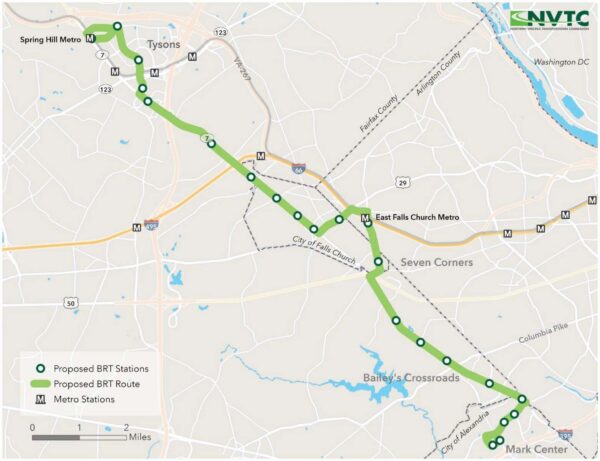
(Updated at 4:25 p.m. on 1/3/2023) An ongoing study of the possibility of having bus rapid transit (BRT) service from Tysons to Alexandria can now proceed confident that the planning will be seen through to completion.
The $1.7 trillion federal spending bill that Congress approved on Friday (Dec. 23), just in time to avert a potential government shutdown, included $2 million to complete all planning and environmental studies needed for the project, known as Envision Route 7.
The Northern Virginia Transportation Commission — the recipient of the funds — has been studying whether and how to bring dedicated bus service to Route 7 between the Spring Hill Metro station in Tysons and the Mark Center in Alexandria since 2013.
The fourth and latest phase of the study — a mobility analysis evaluating the benefits and impacts of BRT — got underway in October 2021. Expected to finish in April, it will be followed by environmental and preliminary engineering design work.
Reps. Gerry Connolly and Don Beyer requested that funds for the project be included in the omnibus bill so it can “complete the planning and National Environmental Policy Act (NEPA) analysis to prepare…for design and construction,” according to a press release from Beyer’s office.
The proposed BRT will provide “high-quality, frequent” bus service along a corridor that’s already the second busiest for buses in Virginia, Connolly said in a separate release:
This BRT project will provide a reliable and affordable transportation option for communities along this corridor; provide a green transportation option that will reduce greenhouse gas emissions and help in the battle against climate change; reduce congestion along a key transportation corridor in Northern Virginia already benefitting from significant economic development and investment; leverage a range of federal, Commonwealth, regional, and local transportation funds; connect major employment centers (U.S. Department of Defense Mark Center, Bailey’s Crossroads, Seven Corners, West Falls Church and Tysons); and further enhance a robust and growing transit system in Northern Virginia.
“The #EnvisionRoute7 BRT will provide as many as 42,000 daily transit trips giving people access to opportunities throughout our region with direct transit connections to Metro at Tysons and East Falls Church, as well as to the new Alexandria West End Transitway,” NVTC said on Twitter, thanking Connolly and Beyer for securing the funds.
The #EnvisionRoute7 BRT will provide as many as 42,000 daily transit trips giving people access to opportunities throughout our region with direct transit connections to Metro at Tysons and East Falls Church, as well as to the new Alexandria West End Transitway.
— NVTC (@NoVaTransit) December 23, 2022
The Tysons segment of the BRT will include six stops, traveling up International Drive and looping around the Spring Hill Metro before taking International back down to Route 7 (Leesburg Pike).
The service will use two transit-only lanes that Fairfax County plans to build by widening Route 7 from Route 123 to the Capital Beltway.
From Tysons, the route continues through Falls Church City, into the Seven Corners and Bailey’s Crossroads area, and down to Alexandria. NVTC held a community meeting to discuss the Falls Church portion in October.
Other Fairfax County projects that got funding from the federal spending package include a cycle track on Sunrise Valley Drive to the Innovation Center Metro station, pedestrian and bicycle upgrades near the Vienna Metro station, and a renovation of the Little River Glen Senior Center near Fairfax City.
(Updated at 4:20 p.m.) On an April day in 1968, Roy “King of the Cowboys” Rogers and his wife — “Queen of the West” Dale Evans — appeared in front of thousands along Leesburg Pike in Bailey’s Crossroads to open America’s first Roy Rogers.
“Inside the shoppe, Roy and Dale served up hot Roast Beef sandwiches to the first several customers,” promotional materials said at the time. “Over 5,000 autographed pictures of Roy and Dale were passed out to customers.”
Yes, despite the Old West motif and being named after a movie star cowboy, the fast food chain known for its roast beef and fried chicken began in Fairfax County, opening its first restaurant at 5603 Leesburg Pike.
Today, it’s now a McDonald’s set to undergo a revamp.
The story behind how Roy Rogers came to be born in Fairfax County starts with J. Willard Marriott, founder of the once-local but now-international hotel chain.
“Mr. Marriott wanted to get into the fast food business,” Jim Plamondon, co-president of Roy Rogers restaurants, told FFXnow. “Just like what Ray Kroc was doing with McDonald’s.”
Marriott began his career running a D.C. root beer shop before transitioning to a coffee shop-style eatery called Hot Shoppe. He opened his first hotel in Arlington in 1957.
But fast food was hot in the 1960s, and Marriott, an experienced restaurant owner, wanted a bite of that market too. So, when a new roast beef franchise called “RoBee’s House of Beef” opened in the Midwest, Marriott decided to acquire it, Plamondon explained.
Plamondon knows this history intimately. His father, Peter Plamondon Sr., was an executive in charge of Marriott’s restaurant division at the time, and he helped the hotel company launch its fast food business.
However, legal reasons prevented the company from acquiring RoBee’s trademark, so they needed a new name.
“One of the people on [Marriott’s] board of directors…said ‘Well, I know the agent for Roy Rogers, the cowboy,'” Plamondon said. “[Rogers] was a rock star back then. I mean, he was huge. He was as big as any movie star you would name today.”
Rogers was also very amendable to licensing his image and name to merchandise and businesses. At one point in the mid-20th century, more than 400 products had Roy Rogers’s name on them — second only to Walt Disney, per Rogers’s official website
Marriott and Roy Rogers struck an agreement, and the new fast food restaurant took on the Hollywood cowboy’s name. Read More
Fairfax County has come up with a plan to improve Seven Corners and will be explaining it to residents next week.
The Fairfax County Department of Transportation (FCDOT) is holding two virtual meetings on Nov. 8 and 9 to update and ask for feedback from residents on its findings from the Seven Corners Phasing Study.
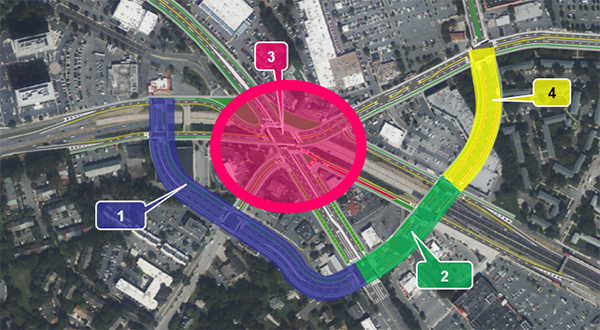
The four-phase plan will build a “Ring Road” that the county believes will improve pedestrian and bicycle safety, as well as relieve traffic congestion, in the Seven Corners area, particularly where Route 7, Arlington Blvd (Route 50), and Wilson Blvd all meet.
The first phase is to build a Ring Road on the west side of the interchange between Arlington Blvd and Route 7. The Ring Road will then be extended to the south side, and the central interchange will be reconfigured above Arlington Blvd where Route 7, Wilson Blvd, and Sleepy Hollow Road meet. The final phase will complete the Ring Road on the east side of the interchange connecting Wilson and Roosevelt Blvds.
The interchanges in and around Seven Corners are known to be confusing and dangerous. As recently as August, it was the site of a tragedy when a driver veered off the road and fatally hit a pedestrian in a nearby parking lot.
The Seven Corners study dates back a decade when a community task force first started discussing the future of the area.
The task force proposed recommendations in 2015 that were adopted into a plan amendment approved by the Board of Supervisors. At that time, FCDOT committed to a “phasing analysis” to determine how and in what order improvements were to be made.
In June 2020, FCDOT started conducting this analysis looking into “future transportation conditions; incorporated feedback received from previous rounds of outreach; and worked with various stakeholders to identify a recommended phasing approach.”
In Feb. 2021, a community meeting was held to update residents on that work and, again, in November.
Now, a year later, FCDOT is reaching back out to the public for a final round of feedback for the phasing study, which is expected to be completed by early next year.
However, there’s no set timeline yet for the project’s engineering and design phase, which is “dependent upon funding,” FCDOT spokesperson Robin Geiger told FFXnow in an email.
“The County has applied for Smart Scale funding from the Commonwealth for the first phase of the project and expects to hear early next year whether funding has been awarded,” Geiger said.
The county will also apply for federal funding as well. Once funding from local, state, and federal become available, design, utility coordination, and right-of-way acquisition will commence.
Once funding is awarded, Geiger said it should be expected that Phase 1 will take two years to construct.
The timeline for the other three phases is hard to predict at this point since they are “contingent upon the availability of funds.”
“We will continue to apply for funding progressively based on construction start for each phase,” Geiger said.
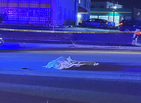
A pedestrian was killed in a hit-and-run on Leesburg Pike late last night.
The crash happened on the 5600 block of Leesburg Pike in the Bailey’s Crossroads area, according to the Fairfax County Police Department.
Police said that the striking car fled the area. The pedestrian was pronounced dead on scene.
Westbound Leesburg Pike was closed around 11 p.m. last night.
FCPD did not immediately release any other information about the incident.
Officers are investigating a motor vehicle crash involving a pedestrian in the 5600 block of Leesburg Pike in Falls Church. The pedestrian was pronounced deceased onscene. Striking vehicle fled the scene. WB Leesburg Pike is closed. Please avoid the area. #FCPD pic.twitter.com/QUbhaTv4QY
— Fairfax County Police (@FairfaxCountyPD) October 27, 2022
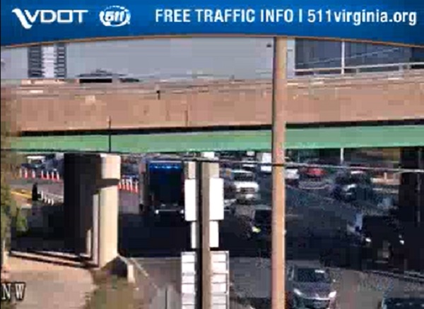
(Updated at 1:50 p.m. on 10/7/2022) Three more people were killed on Fairfax County roads Thursday morning (Oct. 6), police reported.
In Tysons, two people died in a single-vehicle crash on eastbound Route 7 (Leesburg Pike) remains partly shut down in Tysons after two people died in a single-vehicle crash at Chain Bridge Road, shutting down the road for nearly three-and-a-half hours, the Fairfax County Police Department said.
Today (Friday), police identified Lori Byars, 51, of Woodbridge as the driver of a 1986 Mercedes 420 SEL, and 59-year-old Triangle resident David Turch as a passenger.
“The vehicle left the roadway prior to the intersection near the overpass of Chain Bridge Road and struck a light pole,” the FCPD said. “The vehicle continued striking another traffic signal pole where it came to stop.”
Police say speed and alcohol are both believed to have factored into the crash. A few community members who passed by the scene described it as “horrible.”
The Rt 7 Tysons crash was absolutely horrible. Car was almost completely flat except for the rear passenger. Anyone could see that car and know whoever was in there could not have survived.
— zeezy (@drfunk387) October 7, 2022
Further south, 53-year-old Melodie Kiem was struck and killed on Richmond Highway (Route 1) at Backlick Road in the Fort Belvoir area around 6:49 a.m. Thursday.
A preliminary investigation suggests Kiem was walking from the Richmond Highway median to the eastern side when the driver of a 2015 GMC Terrain going north on the highway hit her, the FCPD said.
Police say the driver had a green light, and Kiem was crossing “against the pedestrian cross signal.” At that intersection, Richmond Highway is eight lanes across, including dedicated turn lanes, and there is no crosswalk on the western side.
“The driver remained on scene,” the department said. “Rescue personnel responded and pronounced Kiem deceased at the scene. Preliminarily, speed and alcohol do not appear to be factors in the crash.”
Two lanes are now open on EB Rt7 Leesburg Pike. Crash Reconstruction Unit detectives continue to investigate this crash. Follow our blog, https://t.co/lhGv3NDvYs, for updates when available. #FCPD https://t.co/4vX4ISjVeM
— Fairfax County Police (@FairfaxCountyPD) October 6, 2022
Crash Reconstruction Unit detectives are enroute to investigate. Officers from our Motors Unit are arriving to assist diverting traffic. Avoid the area. Expect delays.
— Fairfax County Police (@FairfaxCountyPD) October 6, 2022
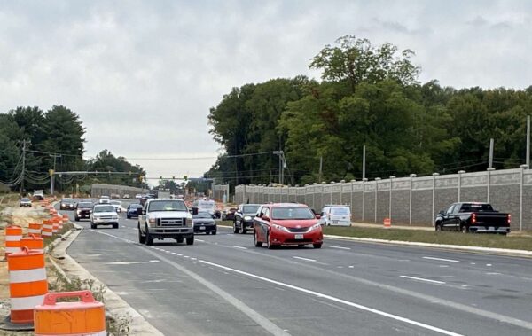
Drivers headed east on Route 7 in Reston can now get a small taste of what the road will be like once it’s fully widened.
A third eastbound travel lane opened along a 2-mile stretch of Route 7 (also known as Leesburg Pike) from Reston Avenue to Riva Ridge Drive on Friday (Sept. 30), the Virginia Department of Transportation announced.
A third westbound lane will open in the same area during the week of Oct. 10, VDOT says, noting that both lanes are arriving “ahead of schedule.”
This is the first segment of new lanes to be finished since construction began over three years ago on the project, which is expanding a 7-mile section of the corridor from four to six lanes between Reston and Tysons.
The $313.9 million project is also adding shared-use paths on both sides of Route 7, replacing the Difficult Run bridge, reconfiguring the Lewinsville Road intersection, and building a new pedestrian underpass at Colvin Run.
Work on the median and noise barriers between Reston Avenue and Riva Ridge will continue until mid-2024, when the full project is scheduled to be complete, according to VDOT’s project page.
(Updated at 6:15 p.m.) — Bailey’s Crossroads, including Route 7 and Crossroads Place, has reopened and shelter-in-place orders have been lifted after reported gunshots prompted a massive police response to the area.
The Fairfax County Police Department continues to investigate the shooting, which reportedly damaged two cars in the 3500 block of Jefferson Street but didn’t result in any injuries.
Initial reports suggested the shots came from a “high-powered rifle” in a nearby high-rise, but police now say detectives have determined that they were fired by a handgun at ground level, according to a press conference broadcast live by NBC4.
“Detectives determined the gunfire was not from an elevated position or from a high caliber weapon,” the FCPD said. “Detectives continue to investigate & remain in the area.”
Throughout this afternoon (Friday), Bailey’s Crossroads residents and visitors were directed to shelter in place after police received a “shots fired” call at 11:15 a.m.
According to scanner traffic, a driver reported hearing a loud noise, and the rear window of their car shattered. Officers at the scene determined that two to three vehicles parked at the Crossroads Place shopping center had been damaged by gunfire.
Two people had been standing in the proximity of both vehicles at the time of the shooting, but neither of them were hit. Police currently believe that the shooting was random, and there is no indication that the people whose cars were hit knew each other, FCPD Lt. Dan Spital told media.
“We have no reason to believe that any specific individual was targeted in the shooting,” he said at the briefing.
Around 12:30 p.m., police told FFXnow that it wasn’t considered an active shooter situation, meaning there was no ongoing gunfire.
However, Crossroads Place was completely blocked off, and Leesburg Pike shut down in both directions. Fairfax County Public Schools also issued “secure the building” alerts at Bailey’s and Glen Forest elementary schools.
“[That] means no outside activities are occurring right now, everyone has been brought inside, doors are locked and the learning continues,” an FCPS spokesperson said around 2 p.m.
Arlington took similar actions at Wakefield High School and Claremont Elementary School.
“Wakefield has been notified of an incident involving police activity near the school,” Arlington Public Schools said. “As a precaution, we have placed the school in Secure-the-Building* status. This means that all doors are locked and no one can leave or enter the building as a precaution.”
FCPD had helicopter, special operations, and patrol officers involved in the search. Arlington first responder units were also dispatched to assist.
While no additional shots were reported after the initial call, Spital said the large emergency response was appropriate, since “we’re always going to err on the side of caution.” Police have not identified any suspects, but the investigation is ongoing, and community members are advised to remain “cognizant.”
“We’re not aware if [the shots] came from a vehicle or a person walking by, but we do have some active leads. We’re combing through a lot of evidence,” Spital said.
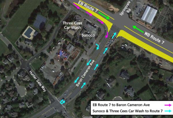
While orange traffic cones are a familiar sight as the widening of Route 7 continues, more changes are afoot at the Baron Cameron Avenue intersection in Reston.
Night work on the project began last night, resulting in detours and changing traffic patterns on eastbound and westbound Route 7, Baron Cameron Avenue and Springvale Road. Detours are planned at night between 10 p.m. and 5 a.m. through Thursday (Sept. 1).
Beginning around Tuesday, Sept. 6, more detours and lane shifts are planned during the same hours, as crews reconfigure the intersection to shift traffic to the north.
All homes, businesses and public facilities will remain accessible.
Here’s more from the Virginia Department of Transportation on signage and changes:
Monday, Aug. 29 – Thursday, Sept. 1, 10 p.m. to 5 a.m.
- The median crossover at Route 7 and Baron Cameron Avenue will be closed.
- Drivers on westbound Route 7 to Baron Cameron Avenue will proceed to Bishopsgate Way, U-turn to eastbound Route 7, and turn right onto Baron Cameron Avenue.
- Drivers on Springvale Road to Baron Cameron Avenue will turn right onto westbound Route 7, U-turn at Bishopsgate Way to eastbound Route 7, and turn right onto Baron Cameron Avenue.
- Drivers on eastbound Route 7 to Springvale Road will proceed to Delta Glen Court, U-turn to westbound Route 7, and turn right onto Springvale Road.
- Drivers on Baron Cameron Avenue to Springvale Road will turn right onto eastbound Route 7, U-turn at Delta Glen Court, proceed on westbound Route 7 and turn right onto Springvale Road.
On or about Tuesday, Sept. 6, 10 p.m. to 5 a.m.
- Drivers will follow the detour routes above and will experience lane shifts on eastbound and westbound Route 7 while crews shift traffic to the north.
Following the traffic shift and continuing through late 2022:
- Drivers on eastbound Route 7 will use a temporary displaced right-turn lane to access Baron Cameron Avenue.
- Access from eastbound Route 7 to the Sunoco Service Center and Three Cees Car Wash will be maintained. To return to Route 7, drivers exiting the businesses will turn right onto Baron Cameron Avenue and U-turn at Hunter Gate Way/Hunter Mill Road.
The project is part of VDOT’s effort to widen almost seven miles of Route 7 from Reston Avenue to Jarrett Valley Drive. The project would widen the road from four to six lanes, add paths and update many of the intersections along the route. Overall, the project is on track for a July 2024 finish.
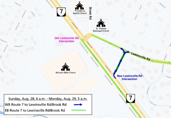
By this time next week, the intersection of Route 7 and Lewinsville Road in the Wolf Trap area will have a whole new look, but drivers must endure some inconveniences before the result of the makeover is revealed.
The median that currently facilitates traffic between eastbound Route 7 and Lewinsville will close at 7 p.m. on Friday (Aug. 26), requiring drivers to take an extended detour through Tysons, the Virginia Department of Transportation says.
Signs will be erected to guide drivers through the detour, which will go from Route 7 to Westpark Drive with a northward turn onto International Drive and Spring Hill Road.
“All residences, businesses and other public facilities will remain accessible via the signed detour route,” VDOT said in the news release.
The new Lewinsville Road will open to westbound Route 7 drivers, who can turn right at the McLean Bible Church intersection.
The detour will remain in place through 5 a.m. on Monday (Aug. 29), but the median will reopen to some movements at 6 a.m. Sunday (Aug. 28):
- Drivers on LewinsvilleRoad/Brook Road will be able to turn left onto eastbound Route 7, turn right onto westbound Route 7, and go straight across to McLean Bible Church at the old Lewinsville Road intersection.
- Drivers from McLean Bible Church at the old Lewinsville Road intersection will be able to turn left onto westbound Route 7, turn right onto eastbound Route 7, and go straight across the intersection to Lewinsville Road/Brook Road.
- Drivers from McLean Bible Church at the new Lewinsville Road intersection will be able to turn right onto eastbound Route 7.
- Drivers on westbound Route 7 will be able to turn left into McLean Bible Church at the old Lewinsville Road intersection.
When the new intersection fully opens at 5 a.m. on Monday, there will be a new, displaced left-turn lane for eastbound Route 7 drivers to access Lewinsville and Brook Road. The service road in front of McLean Bible Church will permanently close.
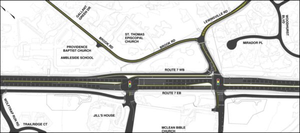
The intersection was previously expected to open in the spring as part of the ongoing project to widen Route 7 from four to six lanes between Reston Avenue and Jarrett Valley Drive.
The intersection’s permanent configuration is scheduled to be completed on Oct. 25, with the overall Route 7 project on track for a July 31, 2024 finish.

