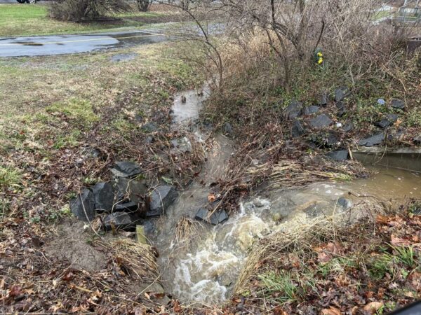
Email signup
A storm has reached Fairfax County, as seen on radar around 4 p.m. on Aug. 14, 2023

Updated at 4:45 p.m.The Tornado Warning was terminated early at 4:33 p.m., but Severe Thunderstorm and Flash Flood warnings remain in effect until around 5 p.m. and 7:45 p.m., respectively.

Updated at 4:25 p.m.A Tornado Warning has also been issued until 4:45 p.m.

“At 418 PM EDT, a severe thunderstorm capable of producing a tornado was located over Franconia, or over Springfield, moving northeast at 25 mph,” the National Weather Service said.

Updated at 4:20 p.m. — The Flash Flood Warning has been expanded to include the Tysons area, Vienna and Annandale.

Earlier: This afternoon’s rush-hour commute will be a wet one.

A thunderstorm has reached Fairfax County, and it could bring some flooding, according to the National Weather Service.

The agency has issued a Flash Flood Warning specifically for the southern half of the county and the Fairfax City area. The alert will be in effect until 8 p.m.

“Turn around, don’t drown when encountering flooded roads,” the NWS said. “Most flood deaths occur in vehicles. Basement flooding can occur quickly and create a life-threatening situation. If you are in a basement, or a residence below street level, move to a higher floor immediately.”

A Severe Thunderstorm Warning is also in effect until 4:30 p.m., affecting the Fort Belvoir, Mount Vernon and Lorton areas.

According to the NWS, radar showed “a severe thunderstorm” moving northeast at 20 mph from Quantico at 4:02 p.m. Wind gusts of up to 60 mph are possible.

“Damaging winds will cause some trees and large branches to fall,” the agency warns. “This could injure those outdoors, as well as damage homes and vehicles. Roadways may become blocked by downed trees. Localized power outages are possible. Unsecured light objects may become projectiles.”

The full Flash Flood Warning is below:

* Flash Flood Warning for…Southern Fairfax County in northern Virginia…Prince William County in northern Virginia…The City of Fairfax in northern Virginia…

* Until 800 PM EDT.

* At 353 PM EDT, Doppler radar indicated thunderstorms producing heavy rain developing across the warned area. Additional rainfall amounts of 1 to 3 inches are possible in the warned area. Flash
flooding is expected to begin shortly.

HAZARD…Flash flooding caused by thunderstorms.
SOURCE…Radar.
IMPACT…Flash flooding of small creeks and streams, urban areas, highways, streets and underpasses as well as other poor drainage and low-lying areas.

* Some locations that will experience flash flooding include…
Centreville…Dale City… Annandale…Springfield… Fairfax…Fort Hunt… Groveton…Huntington… Mantua…Fort Belvoir… Woodbridge…Quantico… Lake Ridge…Burke… Oakton…Lincolnia… Montclair…
Lorton… Franconia…

This includes the following Flood Prone Roads:
Woodburn Road at Accotink Creek…Fairfax Boulevard at Oak Street…Fairfax Boulevard at University Drive…Pickett Rd at Accotink Creek near Old Pickett Rd… Mine Road and Cameron Street…

0 Comments
Power outages in Fairfax area on Aug. 8, 2023 (via Dominion Energy)

Utility crews are still working to restore electricity to over 2,000 customers after last night’s storms.

As of 9 a.m., there were 2,545 people in the county without power, according to PowerOutage.US, which collects data from utilities across the country. That includes 1,672 Dominion Energy customers and 873 customers of the Northern Virginia Electric Cooperative (NOVEC).

The scope of the outages has been reduced significantly overnight after strong winds and rain knocked out power for more than 16,000 people by 7 p.m. yesterday (Monday). The county was hit hardest south of I-66, particularly around Fairfax City and Annandale.

According to its outage map, Dominion Energy is estimating that power will be restored to the still-affected areas around 3-8 p.m. today. Spokesperson Peggy Fox reported around 8:30 a.m. that the company has 6,000 remaining outages at 240 different locations across the region.

There is at least one lingering road closure. Henderson Road near Seven Hills Lane in Clifton is still blocked by a downed tree, the Fairfax County Police Department tweeted, advising drivers to find alternate routes.

Last night, the department said debris and downed wires had closed “several secondary roads,” but no major ones, resulting in limited traffic impacts.

Overall, last night’s storms caused less damage than forecasters had feared. Warnings of potential tornadoes prompted facility closures and an early end to the work day for many, including local federal government employees.

0 Comments

(Updated at 8:05 p.m.) Thousands of people in Fairfax County have been hit by power outages in the wake of a thunderstorm that’s continuing to march eastward toward D.C.

As of 7:15 p.m., there were 16,029 customers in Fairfax County and another 1,770 customers in Fairfax City without power, according to Dominion Energy’s outage map, which shows 90 separate outages.

The most sizable outages appear to be focused south of I-66, with thousands affected around Fairfax City, including around George Mason University’s campus, and Fairfax Station. Major outages also appear in Great Falls, Annandale and Lincolnia.

The outages may have affected the Burke Centre Library and the John Marshall Library in Rose Hill. Fairfax County Public Library says both branches were closed at 6:45 p.m. “due to facilities issues.”

While there have been no reports of hail or tornadoes yet, the storm has kept the Fairfax County Fire and Rescue Department busy with calls for downed wires and trees.

The department reported at 5:54 p.m. that it had units working 12 different calls for outside fires.

Road closures have also cropped up, according to the Fairfax County Police Department. A spokesperson says no major roads have been shut down, but “there are several secondary roads that may have debris or downed wires.”

“Due to inclement weather, multiple roads in Fairfax County are closed or blocked. #FCPD will respond and provide updates as soon as possible,” the department said on Twitter.

Metro, which has activated its Emergency Operations Center, is delaying trains and buses in some areas due to the weather.

0 Comments
The National Weather Service’s radar shows a line of storms approaching the D.C. area from the west (via NWS)

Updated at 5:35 p.m. — The storm has been deemed “destructive” for Clifton, Burke and Annandale, with the National Weather Service warning of “considerable damage to trees and power lines” and that “your life is at significant risk if outdoors.”

Earlier: A storm bringing intense winds and potentially even hail or a tornado is bearing down on the D.C. area.

In anticipation of the weather, the Fairfax County Park Authority closed several outdoor facilities at 4 p.m., including the Water Mine Family Swimmin’ Hole at Lake Fairfax Park in Reston, the Martin Luther King Jr. Pool in Gum Springs and Our Special Harbor Spray Park in Groveton.

All golf courses and driving ranges, marinas and park amusements, like carousels, have also been shut down. Outdoor classes and activities have either been canceled or moved indoors.

With the line of storms moving eastward, the northwestern part of the county is expected to get hit first. The National Weather Service has issued a Severe Thunderstorm Warning until 5:15 p.m. for that area, including Reston, Herndon and possibly Tysons.

The alert warns of 60 mph wind gusts and quarter-sized hail.

“Damaging winds will cause some trees and large branches to fall,” the NWS said. “This could injure those outdoors, as well as damage homes and vehicles. Roadways may become blocked by downed trees. Localized power outages are possible. Unsecured light objects may become projectiles.”

The storm is expected to arrive during the afternoon rush-hour around 5-7 p.m., prompting local federal government offices and other many workplaces to send employees home early.

Metro is “deploying additional resources to respond to weather-related issues” that may affect its service, activating its Emergency Operations Center.

“Severe delays, disruptions, and detours in Metro bus, rail, and paratransit service are possible due to extremely high winds, road conditions and other hazards,” Metro said in a news release.

0 Comments
Storm clouds approaching over Vienna on July 28, 2023 (photo by Jerry Woolsey)

Some more stormy weather could wash over the D.C. area later today.

A Tornado Watch has been issued for the region, including Fairfax County, by the National Weather Service, which has also designated most of the area as at “Moderate Risk” of severe thunderstorms this afternoon and evening.

This is the first time in a decade that the agency has placed the D.C. area under that level of risk for hazardous weather, according to the Capital Weather Gang.

“Widespread damaging wind gusts are likely, with potential for locally destructive winds,” the NWS said. “Tornadoes and large hail are also possible. Have a way to receive warnings!”

The Tornado Watch will be in effect until 9 p.m.

The storms are expected to move eastward, reaching Fairfax County during the afternoon rush-hour, according to the county’s emergency information blog.

Wind gusts of up to 80 mph are possible in central and western Virginia, with most eastern areas facing possible gusts closer to 60-70 mph, the Virginia Department of Transportation said in a news release. The department also warned of localized flooding, large hail and “brief spin-up tornadoes.”

“The safety of the traveling public and our crews is VDOT’s top priority,” VDOT said. “As forecasts and conditions could change, travelers should pay close attention to local weather reports and announcements from officials and limit their travels based on conditions.”

0 Comments
Most of the GW Parkway’s northern section is closed as crews continue to remove trees knocked down by Saturday’s storm (via Google Maps)

(Updated at 1:35 p.m.) The ear-splitting thunder that accompanied Saturday’s rainstorm has faded, but efforts to clean up the resulting damage continue.

All southbound lanes on the northern section of the George Washington Memorial Parkway in McLean and Arlington remained closed during rush hour this morning (Monday), as crews worked to remove fallen trees.

“Currently, the northern section (from Spout Run Parkway to I-495) continues to be closed, with the exception of the northbound lanes from Route 123 to I-495,” the National Park Service said last night, urging drivers “to use caution in the area.”

The cleanup effort is expected to take another three to four days, according to the park service, which has deployed five different teams to assist.

“These closures are necessary to ensure the removal of hazardous trees, including those that have fallen across the roadway and broken limbs that pose a risk to travel lanes,” the NPS said in an update shortly before 1:30 p.m.

According to Dominion Energy, 768 of its customers in Fairfax County are still without power, as of 9:30 a.m.

The largest outage is in the West Falls Church area along Sleepy Hollow Road, affecting 437 people. The estimated time of restoration is still undetermined “pending investigation,” according to the utility company’s outage map.

There are also still smaller outages scattered around the Seven Corners area, Springfield and the Richmond Highway corridor.

Over the past couple of days, Dominion has managed to restore power to most of the 128,000 customers in Virginia who experienced an outage during the storm on Saturday (July 29), including approximately 26,000 people in Fairfax County.

“This was a severe storm with winds as high as 60-80 mph, which caused significant damage to trees, branches and power lines,” Dominion said in a tweet yesterday, stating that its crews would continue working through the evening to restore electricity for all those still affected.

The Fairfax County Fire and Rescue Department said it responded to 238 calls between 4:30 p.m. and 10 p.m. on Saturday — double the call volume it sees on a typical summer Saturday.

Map via Google Maps

0 Comments
Rain at the Sully Place Shopping Center in Chantilly (staff photo by Angela Woolsey)

A Flood Watch is now in effect for the D.C. area, including Fairfax County.

The National Weather Service describes the chances of “slow-moving showers and thunderstorms” this afternoon into the early evening as “likely.”

Issued at 11:26 a.m., the alert will be in place until 8 p.m.

“A few inches of rain is possible in a short amount of time as a result, and may cause rapid rises of water on creeks, streams, urban and poor drainage areas, and in other flood-prone locations,” the NWS says.

Rain has become more plentiful in recent days after the D.C. region experienced drought conditions earlier this year. A storm on Wednesday (July 5) brought at least 1-4 inches of rain, according to the NWS, contributing to flooding and power outages, particularly in the central part of Fairfax County.

The full alert is below:

…FLOOD WATCH IN EFFECT UNTIL 8 PM EDT THIS EVENING…

* WHAT…Flash flooding caused by excessive rainfall is possible.

* WHERE…Portions of DC, Maryland, and northern Virginia, including the following areas: in DC, District of Columbia. In Maryland, Anne Arundel, Carroll, Central and Southeast Howard, Central and
Southeast Montgomery, Charles, Frederick MD, Northern Baltimore, Northwest Harford, Northwest Howard, Northwest Montgomery, Prince Georges, Southeast Harford, and Southern Baltimore. In northern Virginia, Arlington/Falls Church/Alexandria, Central and Southeast Prince William/Manassas/Manassas Park, Eastern Loudoun, Fairfax, Northwest Prince William, Stafford and Western Loudoun.

* WHEN…Until 8 PM EDT this evening.

* IMPACTS…Excessive runoff may result in flooding of rivers, creeks, streams, and other low-lying and flood-prone locations.

* ADDITIONAL DETAILS…
– A couple rounds of slow-moving showers and thunderstorms are likely this afternoon into this evening. A few inches of rain is possible in a short amount of time as a result, and may cause rapid rises of water on creeks, streams, urban and poor drainage areas, and in other flood-prone locations.

0 Comments
A rain storm passes over central Fairfax (via NWS)

Rain is pouring down on Fairfax County, raising the risk of flooding.

The National Weather Service has issued a Flash Flood Warning for the central portion of the county, including Oakton, Annandale, Merrifield and Fairfax City.

In effect until 6:30 p.m., the warning anticipates up to 3 inches of rain in the affected areas. As of 3:25 p.m., between half-an-inch and 1.5 inches had already fallen.

“Turn around, don’t drown when encountering flooded roads,” the NWS said. “Most flood deaths occur in vehicles. Basement flooding can occur quickly and create a life-threatening situation. If you are in a basement, or a residence below street level, move to a higher floor immediately.”

The full flood warning is below:

* Flash Flood Warning for…
Western Arlington County in northern Virginia…
Central Fairfax County in northern Virginia…
The Northwestern City of Alexandria in northern Virginia…
The City of Fairfax in northern Virginia…
The City of Falls Church in northern Virginia…

* Until 630 PM EDT.

* At 325 PM EDT, Doppler radar indicated thunderstorms producing heavy rain across the warned area. Between 0.5 and 1.5 inches of rain have fallen. Additional rainfall amounts of 1 to 3 inches are possible in the warned area. Flash flooding is ongoing or expected to begin shortly.

HAZARD…Flash flooding caused by thunderstorms.
SOURCE…Radar.
IMPACT…Flash flooding of small creeks and streams, urban areas, highways, streets and underpasses as well as other poor drainage and low-lying areas.

Updated at 4:30 p.m. — According to Fairfax Alerts, high water has closed Prosperity Avenue at Morningside Drive in the Mantua area.

As of 4:20 p.m., 926 Dominion Energy customers had lost electricity, according to the utility’s outage map.

The largest outages are in Springfield north of the Mixing Bowl, where 547 people are without power and the estimated time of restoration is 5-10 p.m. Another 147 customers have been affected by outages in Lincolnia, where power is expected to return between 7 p.m. and midnight.

Updated at 4:55 p.m. — Woodburn Road at Spicewood Drive has also closed as a result of high water, per Fairfax Alerts. The closure is located just south of Accotink Creek.

Updated at 6:25 p.m. — A Flood Warning has now been issued, extending to 9 p.m. The NWS says 1-4 inches of rain have fallen so far in the central Fairfax area, along with Alexandria, Arlington and Falls Church.

“Flooding of rivers, creeks, streams, and other low-lying and flood-prone locations is imminent or occurring,” the NWS said. “Streams continue to rise due to excess runoff from earlier rainfall.”

0 Comments
A storm-related power outage in Great Falls on June 27, 2023 (via Dominion Energy)

After failing to materialize yesterday, stormy weather showed up in force around the D.C. region this afternoon (Tuesday).

A Severe Thunderstorm Warning was issued for Fairfax County and the rest of the area for around 2:11-3 p.m. The National Weather Service reported that the east-moving storm had reached the Oakton and Vienna area around 2:09 p.m., bringing 60-mph wind gusts and hail the size of quarters, according to Fairfax County.

“Damaging winds will cause some trees and large branches to fall,” the county’s emergency information blog said. “This could injure those outdoors, as well as damage homes and vehicles. Roadways may become blocked by downed trees. Localized power outages are possible. Unsecured light objects may become projectiles.”

As of 3 p.m., about 2,826 people in Fairfax County and Fairfax City have lost power, according to Dominion Energy.

Per the utility company’s outage map, the largest individual outages appear to be along Fairfax Blvd, where 914 customers are without power, and in Great Falls, where 509 customers are affected.

The Fairfax outage stems from an out circuit and is expected to be restored between 5-8 p.m. Dominion estimates a restoration time of 6-9 p.m. for the Great Falls outage, which is directly attributed to the storm.

In Tysons, downed trees were reportedly blocking the ramp from eastbound Route 7 (Leesburg Pike) to northbound Route 123 (Chain Bridge Road), according to the NWS.

Hail was confirmed in Reston by resident Robyn Matthews, but the storm moved relatively quickly, prompting the NWS to let the warning expire on time at 3 p.m.

“The storm which prompted the warning has weakened below severe limits, and no longer poses an immediate threat to life or property,” a 2:51 p.m. update said. “Therefore, the warning will be allowed to expire. However gusty winds and heavy rain are still possible with this thunderstorm.”

0 Comments
Rain on a car window (staff photo by Angela Woolsey)

Some pretty gnarly weather is bearing down on Fairfax County and the rest of the D.C. area.

The National Weather Service has issued a Severe Thunderstorm Watch for the region until 9 p.m.

A Hazardous Weather Outlook issued earlier that could last until midnight forecast heavy storms with the worst impact expected to be east of I-81, including Fairfax County, where the likelihood of severe weather is considered “moderate.”

“Damaging wind gusts and large hail are the primary threats along with the possibility of a brief tornado,” Fairfax County said in a blog post sharing the NWS alert. “Additionally, there is a threat for flash flooding across the entire outlook area this afternoon and evening.”

According to the Virginia Department of Transportation, the region along and east of I-95 could see wind gusts of “up to 75 mph, large hail and possible isolated tornadoes.”

The department is advising travelers to pay close attention to weather reports and to potential limit travel as conditions evolve, warning that the storm could take down trees and power lines and result in flooding.

“Whenever severe weather is expected, we partner with the Virginia Department of Emergency Management and Virginia State Police to coordinate efforts,” VDOT Commissioner Stephen C. Brich said. “Teams throughout the Commonwealth are prepared to address impacts from this storm. We ask for the public’s assistance to remain safe and stay aware of changing weather and road conditions in their area and along their travel routes.”

The storms are moving to the East Coast from the Midwest, which were hit by hail ranging from the size of a baseball to a grapefruit yesterday (Sunday), according to the Capital Weather Gang. Tornadoes have reportedly damaged dozens of homes and killed at least one person in Indiana.

Here’s more advice on navigating the upcoming weather from VDOT:

Obey all “road closed” signage.

“Turn around, don’t drown” – Do not attempt to travel through flooded roadways. According to the Centers for Disease Control, the primary causes of flood-related deaths occur to individuals driving into or walking in or near flood waters.

  • 6 inches of flood water is enough to knock an adult off of their feet
  • 12 inches can move most cars
  • 18-24 inches can carry away most large SUVs, vans and trucks

Be alert to debris, downed trees and power lines

Move over for emergency crews operating in or near roadways

Be alert to High Wind Advisories, especially on bridges or taller structures. High-profile vehicles such as tractor trailers, SUVs or box trucks are especially vulnerable and should not cross a bridge when a High Wind Advisory is posted.

0 Comments
×

Subscribe to our mailing list