Flooding, power outages, and other impacts from storms are among the top climate change-related concerns for Fairfax County residents, the recently released results of a county survey suggest.
606 community members participated in the survey that the Fairfax County Office of Environmental and Energy Coordination (OEEC) conducted between June 8 and July 2 as part of its Resilient Fairfax initiative, which will produce a plan for how the county can withstand and adapt to the threats introduced by a warming planet.
81% of respondents cited severe storms as a concern, followed by changing temperatures (79%) and flooding (60%), according to the survey results report published on Nov. 8.
55% of respondents said they’re concerned about drought, 40% about fire risks, and 19% listed other climate hazards, including air quality and pollution, health effects, and the impact on plants and animals.
While the survey drew responses from just a fraction of the 1.1 million people who live in Fairfax County, the results still offer insight into the community’s awareness of the risks posed by climate change — and how they are already affecting people’s lives, county staff say.
“It helps us gather information that’s not available through quantitative data that we have,” OEEC Senior Planner Allison Homer said. “People’s opinions or people’s concerns, that’s not something we have access to without asking.”
Flooding
24.6% of the Fairfax County residents who answered the survey said their neighborhood has flooded within the past five years, with 9.8% of residents saying it has affected their home.
Of the respondents who work in the county, 24.8% said they have experienced flooding at their place of employment. 67.1% of respondents said they have witnessed flooding in the county outside their home or work, such as on roads.
The survey identifies Hunter Mill Road, Richmond Highway, George Washington Memorial Parkway, Prosperity Avenue, Huntington Avenue, and Little River Turnpike among the areas most vulnerable to flooding, though Homer says the evenly distributed flood map in the report doesn’t fully align with the county’s data.
“I think it’s sort of biased towards the areas where people lived that are taking the survey,” she said. “Our most flood-prone roads in reality are mostly concentrated towards the eastern part of the county.” Read More

Around noon on June 12, a pedestrian trying to reach a pathway by Dogwood Pool on Green Range Drive in Reston was nearly hit by a vehicle, because the trail was blocked by parked cars.
Three days earlier, another driver failed to yield and sped through a left turn at the Westpark and Galleria Drive intersection in Tysons, almost colliding with a person who was using the crosswalk.
Those are two of more than 350 “near miss” traffic incidents that community members have reported to Northern Virginia Families for Safe Streets (NoVA FSS) since the advocacy group launched a survey on June 17 to collect data on dangerous roadways across the region.
Developed with the help of Virginia Tech graduate students, the Near Miss Survey allows walkers, bicyclists, drivers, and other road users to report instances where they came close to getting into a crash or accident but were fortunate enough to avoid it.
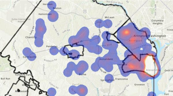
The resulting map highlights specific incidents as well as hotspots that are especially accident-prone, with the goal of helping local transportation and public safety officials see what areas need their attention and how they can improve policies and infrastructure to make streets safer.
“It gives people an opportunity to report on areas that might be dangerous,” Phil Kemelor, the Mason District board member for Fairfax Families for Safe Streets, said. “Just because it doesn’t result in a specific accident like with someone getting hit or killed, it’s still something people should know about.”
While the survey is still new, some trends have already emerged. Unsurprisingly, there tend to be more incidents at times with more traffic, such as the afternoon rush hour, and failure to yield to pedestrians in crosswalks is the most frequently reported issue.

Kemelor notes that the reported incidents haven’t been weather-related, since they’ve all occurred during clear conditions, and they are rarely one-time issues.
“Those reporting the incidents cite multiple occurrences at the locations mentioned,” he said.
The Near Miss Survey project grew out of conversations between NoVA FSS founder Mike Doyle and Tom Sanchez, who teaches urban affairs and planning at Virginia Tech.
As a capstone requirement for the master’s program, graduate students take a year-long studio class where they work on a project with a client from the community.
For the 10 students who took the class during the 2020-2021 academic year, that client was Families for Safe Streets, which began in the City of Alexandria in 2017 and has since added Arlington and Fairfax chapters.
Sanchez says the idea of collecting near-miss data appealed to the class, because there was no existing source for that kind of information, even though a split second could be the only difference between a close call and a tragic collision. Read More


