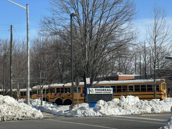
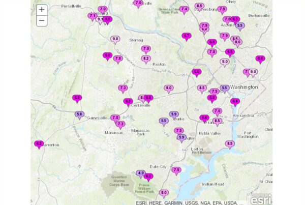
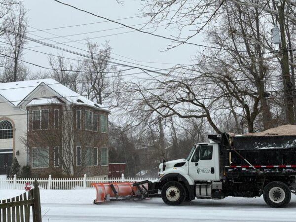
Rain is pouring down on Fairfax County, raising the risk of flooding.
The National Weather Service has issued a Flash Flood Warning for the central portion of the county, including Oakton, Annandale, Merrifield and Fairfax City.
In effect until 6:30 p.m., the warning anticipates up to 3 inches of rain in the affected areas. As of 3:25 p.m., between half-an-inch and 1.5 inches had already fallen.
“Turn around, don’t drown when encountering flooded roads,” the NWS said. “Most flood deaths occur in vehicles. Basement flooding can occur quickly and create a life-threatening situation. If you are in a basement, or a residence below street level, move to a higher floor immediately.”
The full flood warning is below:
* Flash Flood Warning for…
Western Arlington County in northern Virginia…
Central Fairfax County in northern Virginia…
The Northwestern City of Alexandria in northern Virginia…
The City of Fairfax in northern Virginia…
The City of Falls Church in northern Virginia…* Until 630 PM EDT.
* At 325 PM EDT, Doppler radar indicated thunderstorms producing heavy rain across the warned area. Between 0.5 and 1.5 inches of rain have fallen. Additional rainfall amounts of 1 to 3 inches are possible in the warned area. Flash flooding is ongoing or expected to begin shortly.
HAZARD…Flash flooding caused by thunderstorms.
SOURCE…Radar.
IMPACT…Flash flooding of small creeks and streams, urban areas, highways, streets and underpasses as well as other poor drainage and low-lying areas.
Updated at 4:30 p.m. — According to Fairfax Alerts, high water has closed Prosperity Avenue at Morningside Drive in the Mantua area.
As of 4:20 p.m., 926 Dominion Energy customers had lost electricity, according to the utility’s outage map.
The largest outages are in Springfield north of the Mixing Bowl, where 547 people are without power and the estimated time of restoration is 5-10 p.m. Another 147 customers have been affected by outages in Lincolnia, where power is expected to return between 7 p.m. and midnight.
Updated at 4:55 p.m. — Woodburn Road at Spicewood Drive has also closed as a result of high water, per Fairfax Alerts. The closure is located just south of Accotink Creek.
Updated at 6:25 p.m. — A Flood Warning has now been issued, extending to 9 p.m. The NWS says 1-4 inches of rain have fallen so far in the central Fairfax area, along with Alexandria, Arlington and Falls Church.
“Flooding of rivers, creeks, streams, and other low-lying and flood-prone locations is imminent or occurring,” the NWS said. “Streams continue to rise due to excess runoff from earlier rainfall.”
A Flash Flood Warning has been issued for Fairfax, Falls Church and Arlington until 6:30pm.
⚠️ Do not cross flooded roads
👀 Watch for areas of high water
💡 Lights on with wipersReport flooded roads or downed trees to https://t.co/12wxgee8pi or 1-800-FOR-ROAD. https://t.co/mq7edyCf95
— VDOT Northern VA (@VaDOTNOVA) July 5, 2023
Biblical rain in Falls Church at the moment @nbcwashington pic.twitter.com/9uHAjOjNAf
— Adam Tuss (@AdamTuss) July 5, 2023
(Updated at 9:30 p.m.) A Code Red Air Quality alert has been issued for the D.C. region.
In Fairfax County, conditions are expected to worsen to an air quality index (AQI) rating of 164 tomorrow (Thursday), due primarily to particulate matter drifting down to the U.S. from ongoing wildfires in Canada, according to AirNow’s air quality forecast.
A Code Red — which is a step higher than the Code Orange seen today — “means air quality is unhealthy for everyone in Fairfax County and the region,” the county said in a post on its emergency information blog.
With hundreds of wildfires reportedly blazing in Canada, particularly Quebec and British Columbia, the area’s air quality will likely continue to fluctuate “over the next several days,” the county says.
The Metropolitan Washington Council of Governments is encouraging residents to limit their outdoor activities as much as possible.
“If outdoor activities cannot be rescheduled, the EPA recommends limiting time outdoors, taking frequent breaks indoors in places where the air is clean, and choosing a mask that will protect you like an N95,” COG said.
The Fairfax County Park Authority has canceled many outdoor activities for the day, including summer camps and classes, and outdoor water parks and pools will be closed.
The AQI is currently forecast to drop to 84 — a Code Yellow — on Saturday (July 1), according to AirNow, which uses data reported by the Environmental Protection Agency and other local, state and federal government entities.
It doesn’t look like the pollution will quite reach the concentrations seen in early June, when the D.C. area recorded its worst air quality on record as a result of Canadian wildfires.
According to the Canadian Interagency Forest Fire Centre, three new fires started today, and there are 476 active blazes, about half of which remain out of control. The agency has recorded 2,988 fires in 2023 so far that have burned through 8 million acres of land.
If outdoor activities cannot be rescheduled, the EPA recommends limiting time outdoors, taking frequent breaks indoors in places where the air is clean, and choosing a mask that will protect you like an N95. Learn more: https://t.co/pY6aKkuh0E
— COG (@MWCOG) June 28, 2023
🚨 FCPA outdoor camps, activities, programs, pools, amusements, and facilities are impacted or closed on Thursday, June 29, 2023, due to the “Code Red” air quality alert. Please check the website or call the facility directly for updates before visiting: https://t.co/mv3MG2V0md pic.twitter.com/3eIoZOqkge
— Fairfax County Parks (@fairfaxparks) June 29, 2023
After failing to materialize yesterday, stormy weather showed up in force around the D.C. region this afternoon (Tuesday).
A Severe Thunderstorm Warning was issued for Fairfax County and the rest of the area for around 2:11-3 p.m. The National Weather Service reported that the east-moving storm had reached the Oakton and Vienna area around 2:09 p.m., bringing 60-mph wind gusts and hail the size of quarters, according to Fairfax County.
“Damaging winds will cause some trees and large branches to fall,” the county’s emergency information blog said. “This could injure those outdoors, as well as damage homes and vehicles. Roadways may become blocked by downed trees. Localized power outages are possible. Unsecured light objects may become projectiles.”
As of 3 p.m., about 2,826 people in Fairfax County and Fairfax City have lost power, according to Dominion Energy.
Per the utility company’s outage map, the largest individual outages appear to be along Fairfax Blvd, where 914 customers are without power, and in Great Falls, where 509 customers are affected.
The Fairfax outage stems from an out circuit and is expected to be restored between 5-8 p.m. Dominion estimates a restoration time of 6-9 p.m. for the Great Falls outage, which is directly attributed to the storm.
In Tysons, downed trees were reportedly blocking the ramp from eastbound Route 7 (Leesburg Pike) to northbound Route 123 (Chain Bridge Road), according to the NWS.
Hail was confirmed in Reston by resident Robyn Matthews, but the storm moved relatively quickly, prompting the NWS to let the warning expire on time at 3 p.m.
“The storm which prompted the warning has weakened below severe limits, and no longer poses an immediate threat to life or property,” a 2:51 p.m. update said. “Therefore, the warning will be allowed to expire. However gusty winds and heavy rain are still possible with this thunderstorm.”
Severe Thunderstorm Warning including Washington DC, Arlington VA and Alexandria VA until 3:00 PM EDT pic.twitter.com/yIwOq9WR4E
— NWS Baltimore-Washington (@NWS_BaltWash) June 27, 2023
At 2:25 PM EDT, Tysons Corner [Fairfax Co, VA] Broadcast Media reports Tstm Wnd Dmg. The ramp from eastbound VA-7 Leesburg Pike to northbound VA-123 Chain Bridge Road was blocked by downed trees. https://t.co/6fPcuWCyU4 pic.twitter.com/e9iAfmMCCv
— IEMBot LWX (@iembot_lwx) June 27, 2023
Small hail and strong wind in Reston pic.twitter.com/9gRQCqlsN0
— Robyn Matthews (@robyndmatthews) June 27, 2023
Some pretty gnarly weather is bearing down on Fairfax County and the rest of the D.C. area.
The National Weather Service has issued a Severe Thunderstorm Watch for the region until 9 p.m.
A Hazardous Weather Outlook issued earlier that could last until midnight forecast heavy storms with the worst impact expected to be east of I-81, including Fairfax County, where the likelihood of severe weather is considered “moderate.”
“Damaging wind gusts and large hail are the primary threats along with the possibility of a brief tornado,” Fairfax County said in a blog post sharing the NWS alert. “Additionally, there is a threat for flash flooding across the entire outlook area this afternoon and evening.”
Severe thunderstorms are possible this afternoon with localized damaging wind gusts and large hail being the primary threats. Please stay weather aware, and be ready to seek shelter if warnings are issued. pic.twitter.com/cw9lnHTCmC
— NWS Baltimore-Washington (@NWS_BaltWash) June 26, 2023
[2:20 PM] – A SEVERE THUNDERSTORM WATCH IS IN EFFECT UNTIL 9 PM THIS EVENING.
Localized damaging wind gusts, hail, and rain that may cause flash flooding are possible. pic.twitter.com/Bzyn38J36R
— Ready Fairfax (@ReadyFairfax) June 26, 2023
According to the Virginia Department of Transportation, the region along and east of I-95 could see wind gusts of “up to 75 mph, large hail and possible isolated tornadoes.”
The department is advising travelers to pay close attention to weather reports and to potential limit travel as conditions evolve, warning that the storm could take down trees and power lines and result in flooding.
“Whenever severe weather is expected, we partner with the Virginia Department of Emergency Management and Virginia State Police to coordinate efforts,” VDOT Commissioner Stephen C. Brich said. “Teams throughout the Commonwealth are prepared to address impacts from this storm. We ask for the public’s assistance to remain safe and stay aware of changing weather and road conditions in their area and along their travel routes.”
The storms are moving to the East Coast from the Midwest, which were hit by hail ranging from the size of a baseball to a grapefruit yesterday (Sunday), according to the Capital Weather Gang. Tornadoes have reportedly damaged dozens of homes and killed at least one person in Indiana.
Here’s more advice on navigating the upcoming weather from VDOT:
Obey all “road closed” signage.
“Turn around, don’t drown” – Do not attempt to travel through flooded roadways. According to the Centers for Disease Control, the primary causes of flood-related deaths occur to individuals driving into or walking in or near flood waters.
- 6 inches of flood water is enough to knock an adult off of their feet
- 12 inches can move most cars
- 18-24 inches can carry away most large SUVs, vans and trucks
Be alert to debris, downed trees and power lines
Move over for emergency crews operating in or near roadways
Be alert to High Wind Advisories, especially on bridges or taller structures. High-profile vehicles such as tractor trailers, SUVs or box trucks are especially vulnerable and should not cross a bridge when a High Wind Advisory is posted.
(Updated at 10:30 a.m.) It’s another day of poor air quality for Fairfax County and the rest of the D.C. area.
As wildfires continue to burn in Canada, the resulting smoke has clouded the East Coast in a sometimes orange-tinted haze of particulate matter. As of 9 a.m., Fairfax was at 313 on the Air Quality Index (AQI) — a Code Maroon for hazardous air that’s even more severe than yesterday’s Code Red.
Today’s AQI appears to be the highest for the D.C. region since records began in 1999, according to Ryan Stauffer, a NASA scientist who studies air pollution.
The highest alert on the official AQI, Maroon is a health warning of emergency conditions that can affect everyone, according to AirNow, which monitors official air quality based on data reported by federal, state and local agencies.
Air Quality Alert for Thursday, June 8 🚨
Due to the wildfires in Canada, an air quality alert has been issued for today, Thursday, June 8. The air quality is unhealthy for everyone in Fairfax County and the region.
Stay informed: https://t.co/0SheATD3Zg pic.twitter.com/iHffXGXIWh
— Fairfax County Government 🇺🇸 (@fairfaxcounty) June 8, 2023
Record-breaking bad air quality in DC area yesterday dating back to 1999. Today probably will end up worse. https://t.co/YG1C95A31U
— Capital Weather Gang (@capitalweather) June 8, 2023
Everyone is advised to limit their exposure to the air pollution by staying inside or limiting the level of exertion required for outdoor activities, Fairfax County says.
Fairfax County Public Schools has canceled all outdoor activities on school grounds for the day, including recess, P.E., sports and after-school programs. The Fairfax County Park Authority has also canceled all outdoor classes, activities and amusements.
“Wildfire smoke is a mix of gases and fine particles from burning trees and plants, buildings, and other material,” the county said in an emergency blog post. “Wildfire smoke can make anyone sick, but people with asthma, Chronic Obstructive Pulmonary Disease (COPD), or heart disease are more likely to experience health effects of smoke. Pregnant women, babies and children are also at risk.”
In a twist, the masks that proliferated during the COVID-19 pandemic have made a comeback as the most effective way to filter particles from air pollution. In New York, which had the world’s worst air quality yesterday, N95 masks are being handed out for free today.
The worst of the pollution is expected to start clearing tomorrow (Friday), when a Code Orange AQI is forecast, but until then, it’s probably best to stay indoors if possible and mask up.
Image via VDOT
(Updated at 11:35 a.m.) Smoke drifting south from wildfires in Canada has introduced unhealthy levels of air pollution in the D.C. area.
A Code Red Air Quality Alert has been issued for the entire region, including Fairfax County, signaling that the air is unhealthy for everyone today (Wednesday), according to AirNow.
AirNow collects official air quality data reported by the Environmental Protection Agency, the National Oceanic and Atmospheric Administration and other federal, state and local agencies.
Code Red Air Quality Alert 🚨
Due to the wildfires in Canada, a Code Red Air Quality alert has been issued for Wednesday, June 7, which means air quality is unhealthy for everyone in Fairfax County and the region.
Learn more: https://t.co/dMPpgsD1t5 pic.twitter.com/No8JfjQrYF
— Fairfax County Government 🇺🇸 (@fairfaxcounty) June 7, 2023
Fairfax County is advising residents to limit the time they spend outside, particularly if they’re vulnerable to breathing or lung issues:
People with heart or lung disease, older adults, children, and teens – take any of these steps to reduce your exposure:
- Avoid strenuous outdoor activities.
- Keep outdoor activities short.
- Consider moving physical activities indoors or rescheduling them.
- Avoid waiting in long drive-thru lines, for example, at coffee shops, fast-food restaurants, or banks- park your car and go inside.
- Combine trips.
Everyone else – take any of these steps to reduce your exposure:
- Choose less strenuous activities (like walking instead of running) so you don’t breathe as hard.
- Avoid waiting in long drive-thru lines, for example, at coffee shops, fast-food restaurants, or banks- park your car and go inside.
- Re-fuel your vehicle after dark.
- Shorten the amount of time you are active outdoors.
- Be active outdoors when air quality is better.
Fairfax County Public Schools has canceled all outdoor activities until 6 p.m. and implemented indoor recess, spokesperson Julie Moult confirmed to FFXnow, adding that all information will be posted to the school system’s website.
Braddock District Supervisor James Walkinshaw noted that, around 10 a.m., the air quality in Fairfax had actually tipped over into very unhealthy Code Purple territory due to the amount of particulate matter in the air, as measured by the EPA’s Air Quality Index, according to AirNow.
A Code Orange was previously anticipated for today, as smoke from wildfires in Quebec blankets the East Coast.
According to AirNow, the Code Red could be extended into tomorrow (Thursday) with a Code Orange forecast for Friday (June 9).
⚠️ Conditions are hazardous to everyone's health.
Please reduce time spent outdoors as much as possible and follow local media for additional guidance – this account will share updates as they come in. Stay safe everyone.
— Supervisor James Walkinshaw (@JRWalkinshaw) June 7, 2023
The National Weather Service has issued a Red Flag Warning for Fairfax County and the rest of the D.C. area.
In effect from noon until 8 p.m. today (Tuesday), the alert says a combination of strong wind gusts and low humidity have raised the risk of outdoor fires.
“A Red Flag Warning means that critical fire weather conditions are either occurring now, or will shortly,” the NWS said. “A combination of strong winds, low relative humidity, and warm temperatures can contribute to extreme fire behavior.”
The full alert is below:
…RED FLAG WARNING REMAINS IN EFFECT UNTIL 8 PM EDT THIS EVENING FOR GUSTY WINDS AND LOW HUMIDITY FOR VIRGINIA, SOUTHERN MARYLAND, AND EASTERN WEST VIRGINIA PANHANDLE…
* WINDS…West 15 to 25 mph with gusts up to 45 mph.
* RELATIVE HUMIDITY…As low as 15 percent.
* IMPACTS…Critical fire weather conditions are expected through this evening. All outdoor burning is discouraged, as fires could rapidly spread and become uncontrollable.
* FUEL MOISTURE…Dropping to around 7 or 8 percent.
It’s a higher-level warning than the “elevated threat” alert that the NWS issued last Wednesday (April 12) when there were similar weather conditions.
The Fairfax County Department of Emergency Management and Security advises that cigarettes and other smoking materials should be disposed properly in water, sand or an ash tray.
The Virginia Department of Transportation said there were “several reports of brush fires” last week. A brush fire near the Evergreen House apartments in Annandale on Thursday (April 13) affected about 2 acres of land, though the Fairfax County Fire and Rescue Department reported that there were no injuries.
Virginia’s spring fire season typically falls between Feb. 15 and April 30, according to the state’s forestry department.
The D.C. area is currently in the midst of its warmest year on record, the Capital Weather Gang reported, with the 46.9-degree average temperature at Dulles International Airport surpassing the previous record in 2012 by 1 degree.
[4/18 at 12:15 PM] 🚩A Red Flag Warning is in effect until 8 PM. A Red Flag Warning means warm temps, very low humidity, & strong winds are expected to produce an increased risk of fire danger. Dispose of smoking materials properly. Sink it or soak it in water/sand/receptacle. pic.twitter.com/Zkxgs3DAaA
— Ready Fairfax (@ReadyFairfax) April 18, 2023
A #RedFlagWarning has been issued from Noon-8 pm today. We had several reports of brush 🔥 last week during similar conditions, so please dispose of smoking materials properly. #VaWX pic.twitter.com/gnrsgew7Vh
— VDOT Northern VA (@VaDOTNOVA) April 18, 2023
Fairfax County and the rest of the D.C. area should be on alert for potential outdoor fire hazards today (Wednesday), the National Weather Service says.
A combination of wind gusts and dry weather has created an “elevated threat” of wildfires throughout the region until the early evening, according to a special weather statement issued just after 9 a.m.
From the alert, which will be in effect until 8 p.m.:
…ELEVATED THREAT FOR THE SPREAD OF WILDFIRES THROUGH THE EARLY EVENING…
West to northwest winds of 10 to 15 mph are expected with gusts around 20 to 25 mph through this afternoon and relative humidity values will fall to between 20 and 30 percent. Given recent dry weather, fuels are very dry. Therefore, an elevated fire danger will continue until about 8 PM before the winds gradually weaken and humidity rises.
Outdoor burning is strongly discouraged during this time. Please refer to your local burn permitting authority on whether you can burn. If you do burn, use extreme caution and ensure fire suppression is readily available.
Some areas of Northern Virginia further to the west are under a Red Flag Warning.
The fire risk comes as temperatures are expected to reach the low 80s, which is well above average for April, according to the weather service.
That warmer-than-average trend is projected to continue into tomorrow (Thursday) and Friday (April 14), the Capital Weather Gang forecasts, stating that the next couple of days could feel like early summer.
Clouds will be on the decrease this morning, with sunny skies expected during the afternoon hours. Temperatures will be well above normal for April. pic.twitter.com/mOQblDA2p1
— NWS Baltimore-Washington (@NWS_BaltWash) April 12, 2023
The time to get any patio furniture and other loose, outdoor objects inside is now.
At 2:29 p.m. today (Friday), the National Weather Service issued a High Wind Warning for the D.C. area, including Fairfax County, in anticipation of an encroaching storm.
Set to take effect from noon tomorrow (Saturday) until midnight, the alert warns of wind gusts that could reach up to 60 mph, raising the potential for power outages and travel difficulties.
…HIGH WIND WARNING IN EFFECT FROM NOON SATURDAY TO MIDNIGHT EDT SATURDAY NIGHT…
* WHAT…Southwest winds 20 to 30 mph with gusts up to 50 mph Saturday afternoon, becoming northwest 25 to 35 mph with gusts up to 60 mph Saturday evening.
* WHERE…Portions of central and northern Maryland, The District of Columbia, and northern Virginia.
* WHEN…From noon Saturday to midnight EDT Saturday night. The strongest winds are expected Saturday evening.
* IMPACTS…Damaging winds will blow down trees and power lines. Widespread power outages are expected. Travel will be difficult, especially for high profile vehicles.
“People should avoid being outside in forested areas and around trees and branches,” the NWS said. “If possible, remain in the lower levels of your home during the windstorm, and avoid windows. Use caution if you must drive.”
The storm has been moving east after slamming California with heavy winds, rain and snow earlier this week. Nearly 90 million people across 21 states are under a hazardous weather alert, as the Midwest and some Southern states face the risk of tornadoes just a week after one killed at least 26 people in Mississippi and Alabama.
[3/31 at 2:55 PM] The @NWS_BaltWash has upgraded the High Wind Watch to a Warning tomorrow (April 1). Sustained 20-30 mph winds can be expected, w/ gusts up to 50 mph Saturday afternoon. By the evening, sustained winds are expected to be 25-35 mph w/ gusts up to 60 mph. #VaWx pic.twitter.com/QKAzOkXvXU
— Ready Fairfax (@ReadyFairfax) March 31, 2023
(Updated at 2:35 p.m.) Hundreds of people in Fairfax County have lost electricity today (Tuesday) as winds buffet the D.C. region, taking out power lines and contributing to at least one fire.
Georgetown Pike is currently closed in both directions at Miller Avenue in Great Falls due to a tree that fell on power lines and “a resulting fire,” the Virginia Department of Transportation said shortly after 1 p.m.
The closure extends between Stephanie Circle and Ellsworth Avenue, according to the Fairfax County Police Department.
“Expect delays for several hours as emergency and utility crews clear the scene,” VDOT tweeted.
#GreatFalls: Georgetown Pike at Miller Rd closed in both directions for a fallen tree on power lines and a resulting fire. Expect delays for several hours as emergency and utility crews clear the scene. #VATraffic #NOVA #DMVTraffic pic.twitter.com/okCC4QQeQ5
— VDOT Northern VA (@VaDOTNOVA) March 14, 2023
TRAFFIC ALERT: Georgetown Pike is closed between Stephanie Circle and Ellsworth Avenue in Great Falls due to a tree on wires. The closure is expected to last several hours. Please use an alternate route. #FCPD pic.twitter.com/2n569vx8t1
— Fairfax County Police (@FairfaxCountyPD) March 14, 2023
That one outage has affected 277 Dominion Energy customers, according to the utility company’s outage map. Power isn’t expected to be restored there until 4-9 p.m.
Further south in the Vienna and Oakton area, Dominion crews are assessing the damage caused by the wind storm in the Lake Vale neighborhood. Power is now being restored to over 800 customers.
Vale Road has been closed between Hunter Mill Road and Stryker Avenue due to fallen power lines, according to Fairfax County police.
“The closure is expected to last several hours. Please use an alternate route,” the FCPD said.
TRAFFIC ALERT: Vale Rd is closed between Hunter Mill Rd and Stryker Ave in Vienna due to power lines in the roadway. The closure is expected to last several hours. Please use an alternate route. #FCPD pic.twitter.com/fbWvWKo1k7
— Fairfax County Police (@FairfaxCountyPD) March 14, 2023
While those are the largest outages reported so far, power losses and road closures due to fallen wires have been seen across the county today. As of 1:50 p.m., about 1,268 Dominion Energy customers in the county were without power.
The National Weather Service issued a Wind Advisory that took effect at 9 a.m. today and will remain in place until 2 a.m. tomorrow (Wednesday).
Winds have been consistently exceeding 40 mph, with some gusts topping 50 mph, according to the Washington Post’s Capital Weather Gang.
The Wind Advisory has been updated and is now in effect from 9 AM this morning (3/14/23) to 2 AM Wednesday (3/15/23).
Use extra caution when driving, especially if operating a high profile vehicle. Secure outdoor objects. pic.twitter.com/CGgjWXbXsW
— Ready Fairfax (@ReadyFairfax) March 14, 2023
A #windadvisory is in effect until 2 a.m. 🍃
Here's a list of who to contact if you see a downed tree or wires: https://t.co/PGVTIaoj2z
If there’s an immediate life-safety issue, call or text 9-1-1. pic.twitter.com/yIRKqS0u8Y
— Fairfax County Government 🇺🇸 (@fairfaxcounty) March 14, 2023
Not a fun day outside, DC. Temps barely above 40 and winds pretty consistently gusting over 40 mph. Here are peak gusts so far– a few spots topping 50 mph. pic.twitter.com/yiTYLHwSBs
— Capital Weather Gang (@capitalweather) March 14, 2023