The Fairfax County Planning Commission will take another stab at a major overhaul of Reston’s defining planning document next month.
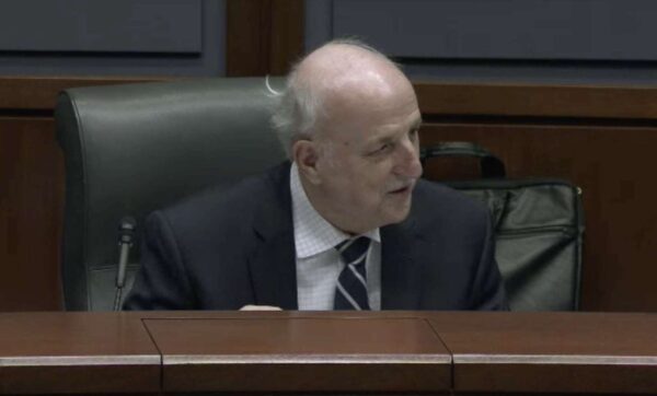
At a Wednesday (June 28) meeting, the commission once again deferred a decision on the extensive update of Reston Comprehensive Plan to July 12 — a move that Hunter Mill District Commissioner John Carter said would allow staff time to incorporate proposed revisions. The commission first deferred a decision on the project on June 14.
The draft under consideration is the product of more than three years of work and dozens of community meetings.
In May, staff released its version of the plan after a first draft was formulated last year by a task force assembled by Hunter Mill District Walter Alcorn in 2020. On June 13, staff also released a 25-page addendum to the report.
Ahead of the commission’s meeting, the county released a chart with county responses to all public testimony received at the last public hearing — a move that Carter said was unusual but helpful to delineate proposed recommendations and the responses from the county.
“We don’t usually go through and address each of the people that testify,” Carter said.
Carter — who walked through a series of suggested revisions during the Wednesday meeting — said the transportation section clearly identifies multimodal components and removes the infamous “road to nowhere” that cuts from Isaac Newton Square to American Dream Way through the Hidden Creek Country Club golf course.
He said he opposes a proposed road connection from American Dream Way to North Shore Drive — a connection that drew significant opposition at the public hearing earlier this month.
Citing safety concerns, Carter said the connection would be dangerous and contradicts the county’s recent consideration of a project that essentially makes American Dream Way a private street.
“If we’re leading this, we just approved a project that did not provide that connection and made American Dream Way a private connection,” Carter said.
Braddock District Commissioner Mary Cortina called a bicycle map in the plan “unreadable” and in need of edits.
“I’m hesitant to continue to put that forward in there without being able to understand what it says or where its going,” Cortina said.
According to Carter, the environment section was pared down in response to concerns that it exceeded the limits of the policy plan and set higher standards for stormwater management in Reston than elsewhere in the county. Those policies include moving towards net-zero energy use, achieving LEED platinum for more buildings, and adding more electric vehicle charging stations.
While these regulations are “good ideas,” the “form” was not right, Carter said.
“I know we struggled quite a bit with that chapter, but I think it’s come out pretty good,” he said.
Carter stressed the need to ensure Reston is able to retain existing market rate affordable housing within the transit station areas (TSA) while establishing new affordable housing.
He seemed to share Cortina’s concerns about the document’s readability, saying that he initially hoped it could have been a gold standard for other similar policies in the county and throughout the state with a combination of graphics, fonts and other enhancements.
Franconia District Commissioner Daniel Lagana suggested adding Geographic Information System (GIS) components to the plan — a suggestion that Chris Caperton, deputy director of the county’s Department of Planning and Development, said was a possibility in future iterations.
Carter said he was still happy the plan was reduced by roughly 40 pages and emphasized more active verbs. He pitched several options for imagery and captions to staff.
Fairfax County’s plan for bus rapid transit (BRT) service on Route 7 in Tysons sailed through the planning commission last week.
The commissioners recommended on Wednesday (June 21) that the Fairfax County Board of Supervisors approve a comprehensive plan amendment establishing guidelines for the future public transportation system, including the route and station locations.
If the amendment is approved at the board’s scheduled public hearing on July 25, the project will become eligible for funding through the county’s Transportation Priorities Plan and state and regional grants, Fairfax County Department of Transportation senior planner Sean Schweitzer told the planning commission.
“This is for future planning. This is not an immediately funded initiative. It’s also very timely,” Planning Commission Vice Chairman Timothy Sargeant noted, referencing FCDOT’s collaboration with the Northern Virginia Transportation Commission on a larger study that could eventually extend the Route 7 BRT to Alexandria.
Known as Envision Route 7, that study has been underway since 2013 and shifted its focus last fall to a portion of the system that will run through Falls Church City down to Seven Corners.
Because the Tysons section is at a more advanced stage of planning, with an overall route alignment in place since 2021, Fairfax County hopes to initially implement service within Tysons down to the West Falls Church Metro station as a temporary southern terminus.
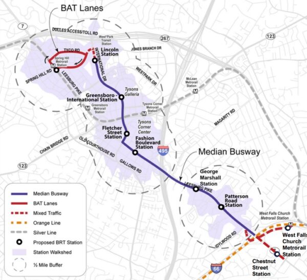
As shared with the planning commission at a committee meeting on May 11 and with the public at virtual community meetings on June 7 and 8, the Route 7 BRT will serve nine stops in the Tysons area:
- West Falls Church Metro
- Route 7 (Leesburg Pike) at Chestnut Street
- Patterson Road, near the Tysons Station and Idylwood Plaza shopping centers
- George C. Marshall Drive
- Fashion Blvd, serving Tysons Corner Center
- International Drive and Fletcher Street
- International and Greensboro Drive, next to Tysons Galleria
- International and Lincoln Circle
- Spring Hill Metro station
To give the buses a clear path, since BRT is intended to be faster than a regular local bus service, the county has proposed designating two future lanes on Route 7 (Leesburg Pike) as BRT-exclusive lanes. The service will also repurpose two existing lanes on International Drive to Lincoln Circle.
The buses will occasionally enter mixed traffic at the West Falls Church station and when turning left from International Drive onto Spring Hill Road, where they will use Business Access and Transit (BAT) lanes to reach the Metro station.
“We know that the middle of Tysons doesn’t really have too much in the way of transit options,” Schweitzer said. “So, this preferred alignment helps to kind of expand the overall transit network within Tysons and gives people…different modes to use in order to get around Tysons and, ultimately, in the future, to Alexandria.”
FCDOT staff is studying how to incorporate improvements for bicyclists and pedestrians into the project, Schweitzer told the commission. Also to be determined is whether the BRT will keep stopping at the West Falls Church Metro station or stay on Route 7 after service is extended into Falls Church.
Franconia District Commissioner Dan Lagana suggested the county could learn from the existing BRT systems in Arlington and Alexandria when designing bicycle and pedestrian facilities, such as wider or raised crosswalks.
“I use and drive by, for example, the Metroway in Alexandria frequently, and…the city has done an outstanding job, Arlington and Alexandria,” Lagana said. “But there are some clear gaps now that we’ve seen it in action and we know crosswalks in the area are insufficient.”
Schweitzer said the county has been collaborating with its neighbors in Arlington, Alexandria and Falls Church, including through the Envision Route 7 study.
“We’re making sure all our transit projects and studies are kind of lining up so it can create, in the future, an expansive BRT system and also connect to the West End Metroway as well in Alexandria,” he said.
A planned data center on the south side of Route 50 near Stonecroft Blvd is already stirring up some controversy, well ahead of a hearing before the Fairfax County Planning Commission.
An affiliate of Penzance, a D.C.-based firm, is seeking the county’s permission to rezone a nearly 12-acre piece of land to develop one of two options: a 402,000-square-foot data center or a 150,000-square-foot warehouse.
Sully District Supervisor Kathy Smith said a Fairfax County Planning Commission meeting originally set for June 28 has been deferred. She plans to host a community meeting sometime in July.
“The applicant did not reaffirm their affidavit in time,” Smith said regarding the hearing’s deferral.
To move forward with the plan — called Chantilly Premier — the county would have to rezone the property from a split zoning of light and heavy industrial uses and commercial uses to industrial uses with a higher developmental intensity.
Although the proposed data center would exceed the recommended intensity of uses outlined by the county, staff said that increased intensity was justified because the land is located in the Route 28 Special Tax District.
The applicant also wants a special exception to increase the allowed height of the data center from 75 feet to 110 feet, arguing that the added height is necessary to accommodate rooftop equipment and screening.
The data center option would include 50 parking spaces to the south of the three-story building, four loading spaces, and an 8-foot-tall security fence within the outside of an environmentally sensitive area.
The second option for a warehouse would include 150 parking spaces, a loading dock with 30 spaces, trailer parking, and a stormwater bio-retention area. The applicant would also pursue LEED green building certification for the warehouse.
The proposal has already gained opposition from residents of the Pleasant Valley neighborhood in Chantilly.
Cynthia Shang, who lives in the community of more than 500 single-family homes, said the neighborhood has serious concerns about the proposal’s intensity, incompatibility, and environmental impacts.
“Our top concern is that our representatives are rubber stamping these data centers with little regard for the negative impacts to the residents’ quality of life and the environment,” she told FFXnow by email. “Neither the data center nor the ‘fallback’ parcel distribution warehouse (which would require air and noise polluting diesel fueled semi-trucks to U-turn at Pleasant Valley, endangering our student drivers going to Westfield HS) are appropriate for the environmentally sensitive area.”
At the requested height, the data center would dwarf surrounding buildings, Shang said. She’s also concerned about noise generated from 115 exhaust fans, 18 air handling units and 20 diesel generators, along with potential impacts of having diesel and exhaust fluid near environmental sensitive areas.
“That amount of diesel and exhaust fluid immediately adjacent to the Comprehensive Plan’s sensitive environmental areas, including a tributary that flows to the Occoquan Reservoir that supplies our drinking water, should not be acceptable,” she wrote. “Accidents and fires happen. This upzoning to accommodate data centers must stop.” Read More
The Fairfax County Planning Commission unanimously deferred a decision on the Reston Comprehensive Plan overhaul at a public hearing Wednesday (June 14) night.
The move — which delays a vote to June 28 — came as public testimony at the hearing centered around a challenge facing Reston: navigating growing pains as it chases a new transit-oriented future while also trying to preserve its past.
Hunter Mill District Planning Commissioner John Carter said county staff and the commission will release a new document that outlines community requests by chapter, staff responses and the commission’s decision on each item.
“We’re going to be working hard in the next couple of weeks,” Carter said.
Some residents and community organizations asked the commission to defer a vote because they needed more time to review a supplement to the plan that staff released on June 13, one day before the hearing.
“We are still pouring through the 25-page addendum,” said Lynne Mulston, president of the Reston Citizens’ Association.
Notable revisions in the addendum include a recommendation that multifamily housing be allowed anywhere in Reston’s transit station areas, not just within a half-mile of the Metro stations, and language encouraging the addition of affordable housing, not just the preservation of existing units.
Underway since 2020, the Reston Comprehensive Plan update lays out the county’s vision for the 6,750-acre area’s development, touching on everything from transportation to density recommendations for the transit station areas and village centers.
The proposed draft was shaped by county staff and a community task force convened by Hunter Mill District Supervisor Walter Alcorn in 2020.
Speakers overwhelmingly opposed a proposed vehicular connection between North Shore Drive and Sunset Hill Road via American Dream Way. Citing concerns about traffic safety, residents argued that the proposal would turn North Shore Drive into a thoroughfare and cut-through street.
“It would be highly unsuitable and dangerous for North Shore Drive to become a thoroughfare,” said local resident Christopher Bean.
Another resident who took issue with the proposal said he moved to the area to have a place for his daughter, who stood alongside him as he testified.
Speaking on behalf of the Greater Reston Chamber of Commerce, Mike Jennings emphasized that the task force did not reach consensus on the version it produced.
Jennings said a tie vote on the initial plan was broken when an abstaining member shifted the vote in favor of the plan. He called staff’s version of the plan a “significant improvement” because it trimmed down “erroneous,” “impractical,” and “prescriptive” language.
Trimming the task force’s version of the draft plan from 180 pages to 133, county staff’s version is intended to avoid prescriptive language in specific areas, especially land use, that could conflict with countywide policies. Initially separate chapters about equity and community health were consolidated into one chapter related to “new town” elements.
The plan also covers Reston Town Center North — an area that is in limbo but is also slated for major redevelopment. The proposed draft recommends limiting residential development to 1,000 dwelling units with all new market rate units consolidated on three blocks. The remaining four blocks would have up to 150,000 square feet of nonresidential development, including civic and public uses. Read More

The proposed repurposing of Inova Health System’s former corporate headquarters in Merrifield as live/work and workforce housing units got a hearty recommendation from the Fairfax County Planning Commission earlier this week.
The commission recommended on Wednesday (June 7) that the Fairfax County Board of Supervisors approve the plan from Madison Highland, a developer focused on live/work projects that’s pursuing similar conversions at the Skyline Center in Bailey’s Crossroads.
“This is an art-of-the-possible application,” Providence District Commissioner Phil Niedzielski-Eichner said. “It started with a vision…but then, that interaction between the applicant and staff resulted in an outcome that is so strikingly beneficial to our county that, to me, it’s a remarkable achievement.”
Under the name Madison Investment Portfolio LLC, the developer is seeking to turn a vacant, 245,000-square-foot office building at 8110 Gatehouse Road into 240 live/work units, which are newly defined in the county’s zoning ordinance as areas designed to accommodate both a residence and a “flexible work space.”
The 89,000-square-foot office building at 2990 Telestar Road will be repurposed as 82 workforce dwelling units for residents earning up to 60% of the area median income.
Representing the applicant at Wednesday’s public hearing, McGuireWoods Managing Partner Greg Riegle pitched the new units and accompanying open space, sidewalks, and other amenities as a “significant” improvement over the existing offices, which have been empty since Inova finished moving out last fall.
“The site gets greener, more amenitized,” he said, “and something that was exclusively automobile-oriented becomes much more walkable…We take a significant step toward creating a centerpiece where people can gather and interact that’s never existed in this part of Merrifield.”
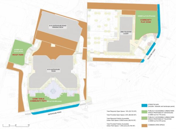
The development will feature three publicly accessible parks — a game table community park, a play zone and a “Woof Park” for dog walking — as well as three common areas for residents. Pickleball courts are also proposed on top of the Gatehouse building’s five-story parking garage.
Pedestrians will get 6-foot-wide sidewalks in front of both buildings, internal walkways for the new parks, a connection between the properties, and high-visibility crosswalks at all crossings, pending Virginia Department of Transportation approval.
Two area residents called for more roadway improvements to address safety concerns and vehicle speeds, particularly on Gatehouse Road.
“I see a lot more rush of people cutting off the corner coming up Lee Highway all the way to Gallows,” a resident of the High Point at Jefferson Park townhomes said. “Maybe at 3 o’clock after noon, there are 20 cars waiting for the red light to turn onto Gallows, so it’s already quite congested.”
The resident also said parking has been a persistent challenge for her neighborhood and the adjacent Yorktowne Square Condominiums, requesting that they be allowed to use the Gatehouse garage.
While Niedzielski-Eichner said parking access should be negotiated by the developer and homeowners separately from the rezoning application, Marc Dreyfuss with the Fairfax County Department of Transportation shared that Gatehouse Road is scheduled for a repaving this year that will create buffered bicycle lanes.
“Restriping the road through a road diet and adding the features that are proposed with this application should help slow the traffic,” Dreyfuss said, confirming that “we would not expect to see any significant increase” in traffic with the proposed development.
The application is set for a public hearing before the Board of Supervisors on June 27.
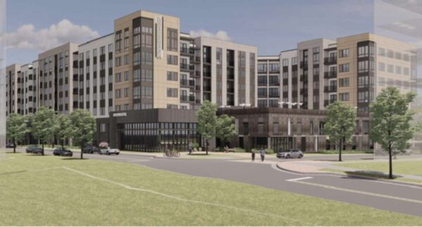
The final pieces of the massive Arrowbrook Centre development near Herndon’s Innovation Center Metro station got the Fairfax County Planning Commission’s unanimous support last week.
The commission recommended on May 24 that the Fairfax County Board of Supervisors approve changes to the final, nearly 10-acre section of the mixed-use development, which is being built and managed by a Launders Charitable Trust.
Specifically, the proposal swaps a 435-unit residential building called Aura from the eastern corner of the property with an office building directly east to it. Aura will be constructed by Trinsic Residential Group.
The swap pushes a hotel planned at the site further east, leaving space for two office buildings at the corner of the site, according to Tabatha Cole of the Fairfax County Department of Planning and Development.
The proposal also removes a parking structure in the land bay.
“Arrowbrook is not seeking to increase any density or any of the uses that are approved,” said John McGranahan, a partner with Hunton Andrew Kurth LLP.
But it’ll be a few years before the office and residential units will go online. To maintain the terms of the charitable trust that govern the development, the developer plans interim uses.
Early talks are underway for a potential partnership with the Virginia Tech Foundation and Virginia Cooperative Extension, a venture that focus heavily on sustainable agriculture, culinary arts and urban farming programs.
“That will be the home run,” McGranahan said. “That is what we’re hoping for. That’s what we’re planning for.”
If that plan falls through, the developer plans to install a community garden in addition to other uses like a lighted trail and outdoor plaza.
Jeff Fairfield, the trust’s manager, said the lease could be ready by the first half of next year, with the community garden as a fallback.
“My preference would be community-wide, first come, first serve,” Fairfield said regarding how use of the garden would be determined.
Hunter Mill District Commissioner John Carter clarified that the setback of the building near the Dulles Toll Road will be 71 feet instead of 200 feet — the current requirement in the county’s zoning ordinance. An exemption was supported by county staff.
Several planning commissioners lauded the developer for the quality of services provided. Braddock District Commissioner Mary Cortina called Arrowbrook Park — a park created by the developer — “stunning.” The developer also built a nearly 1,550 linear feet trail from Centreville Road to the Metro station.
“It’s pretty striking to go to that colosseum of a field out there and to see the high quality that it is,” Cortina said, adding that “you can really see the work that was done on that park.”
But some residents said they were concerned about issues related to traffic from construction and unmet promises of a grocery store and other retail on the site. Read More

Plans for a Route 7 bus rapid transit (BRT) system in Tysons are starting to take more concrete shape, outpacing an ongoing study of the corridor further to the south.
The service will initially launch in Tysons, operating between the Spring Hill and West Falls Church Metro stations, before later expanding into Falls Church and Alexandria, Fairfax County Department of Transportation staff told planning commission members at a May 11 committee meeting.
“Since the northern portion is kind of on a fast track, we would make this the first phase to see how it works,” Sean Schweitzer, a senior transportation planner for FCDOT, said. “It would work in the interim as a closed system until the rest can catch up.”
During the interim phase, the BRT will have nine stops, according to a comprehensive plan amendment proposed by county staff:
- The West Falls Church Metro station
- Westbound Route 7 (Leesburg Pike) at Chestnut Street
- Patterson Road, near the Tysons Station and Idylwood Plaza shopping cneters
- George C. Marshall Drive
- Fashion Blvd, serving Tysons Corner Center
- International Drive and Fletcher Street
- International and Greensboro Drive, next to Tysons Galleria
- International and Lincoln Circle
- Spring Hill Metro station
In the future, the Fletcher Street station could serve as a transfer point for an “enhanced” Gallows Road transit system, Schweitzer said. A study of that corridor down to Annandale is only just gearing up.
The route follows the preferred alignment along International Drive that the Fairfax County Board of Supervisors approved in 2021. The West Falls Church Metro was chosen as an interim southern terminus so buses can turn around, but the county hasn’t ruled out the possibility of making it a permanent station.
“If [the BRT is] better served by going directly to the Metro station, where it can pick up more passengers versus staying on Route 7, we could make that adjustment and have that be the ultimate alignment,” Fairfax County Transportation Planning Chief Mike Garcia said.
Except for the Metro stations, each stop will have separate platforms for east and westbound travel, staggered to reduce right-of-way needs, according to county staff.
The buses will mostly utilize dedicated median lanes, but they have to join other traffic at the Metro stations and to make the left turn from International Drive to Spring Hill Road. Spring Hill and Tyco roads will have “Business Access and Transit” (BAT) lanes limited to buses and drivers turning into the commercial area east of the Spring Hill Metro station. Read More
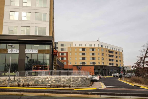
Several pieces of the massive Arrowbrook Centre development in Herndon are barreling toward approval by the Fairfax County Planning Commission.
The commission is set to consider the application — which would transform roughly 54 acres of the site into a mixed-use development — at a public hearing on Wednesday (May 24).
The first piece of the application involves redirecting unused density from six completed land bays into Land Bay A, a nearly 10-acre piece of land on the northern edge of the property. The second piece of the proposal seeks the county’s permission to develop a 435-unit apartment building on a 4-acre site.
“The modifications do not negatively impact the previously approved mix of residential, office, retail and hotel uses or overall approved street network,” county staff said in a May 10 report.
Specifically, the developer has proposed shifting the location of office uses, eliminating a parking garage, relocating some residential uses and a hotel, and consolidating two land bays to allow the development of the apartment building.
The apartment building will include three elevated courtyards, an entry plaza, a parking garage and on-street parking.
In its report, staff recommended approval of the applications.
Overall, nearly 32% of the total property will be used as open space. That excludes nearly 20 acres of parkland dedicated to the Fairfax County Park Authority. It will include a lighted, synthetic turf field, a panic shelter, bocce court, tennis courts, a playground, basketball court, and a butterfly garden,
Most of the public road improvements and internal street system have already been constructed. The new application includes a handful of minor additions, including a 6-foot-wide sidewalk around the apartment building and connections to other areas of the massive site.
The application is one of several in the county that was affected by the Virginia Supreme Court’s ruling that temporarily voided Fairfax County’s newly modernized zoning ordinance.
Although the updated zoning ordinance was re-adopted earlier this month, a petition asking the state court to revisit the case is in progress. The current Arrowbrook application was reviewed against both the 1978 zoning ordinance and the latest ordinance, which took effect for a second time after the Board of Supervisors voted on May 9.
Arrowbrook Centre is located south of the Dulles Airport Access Road, bounded by Centreville Road to the east. Upcoming tenants to the development include the South Asian grocery store Hello2India and Ornery Beer Company Public House.
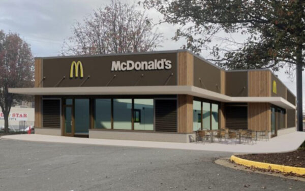
The McDonald’s in Bailey’s Crossroads is a step closer to making some big changes, thanks to the blessing of the Fairfax County Planning Commission.
The commission voted unanimously on May 17 to recommend approval of several upgrades to the site at 5603 Leesburg Pike, including the addition of a second drive-thru lane and a 1,300-square-foot expansion.
Mason District Planning Commissioner Daren Schumate said that, after multiple deferrals of the vote, McDonald’s sufficiently addressed issues flagged by the commission and staff at a March 15 public hearing.
Schumate said the fast food company agreed to green building requirements and additional landscaping in response to the county’s concerns. The company also shifted a handicap parking spot slightly to avoid a tree that was near the spot.
“With that, it looks to me they’ve done good job of addressing concerns,” Schumate said.
However, the company did not agree to add a sidewalk that would connect the site to another property, because they argued it was out of the scope of the project. Staff concurred with the applicant, which has committed to providing a 10-foot-wide trail along Leesburg Pike.
Moving forward with the expansion would require the demolition of an adjacent office building, according to the application. The building was built in 1960.
An additional lane and ordering station is proposed with a median separating the lanes. Customers would enter the drive-thru area along the northwestern corner of the building and circulate clockwise to reach the drive-thru. The exit point is at the northeastern corner of the restaurant, according to the application.
To accommodate the expanded drive-thru, the company plans to redesign the parking lot. Existing parking spots on the eastern property boundary along the northern building facade would be removed to make space for a new sidewalk along Carlin Springs Road. The trash collection area would also be relocated further west of the parcel.
The applicant is seeking a 16% reduction in the number of parking spots required. Instead of 56 spaces, the applicant intends to provide 47 spaces.
The company also plans to install fully transparent windows, along with an outdoor seating area with chairs and tables at the front entrance of the building.
The Fairfax County Board of Supervisors will hold a public hearing on the application tomorrow (Tuesday) to determine whether it’s ultimately approved.
The site that currently hosts the Bailey’s Crossroads McDonald’s was originally home to the very first Roy Rogers. McDonald’s also recently moved to refresh its restaurant at 6729 Arlington Blvd, which is its oldest franchise in Fairfax County.
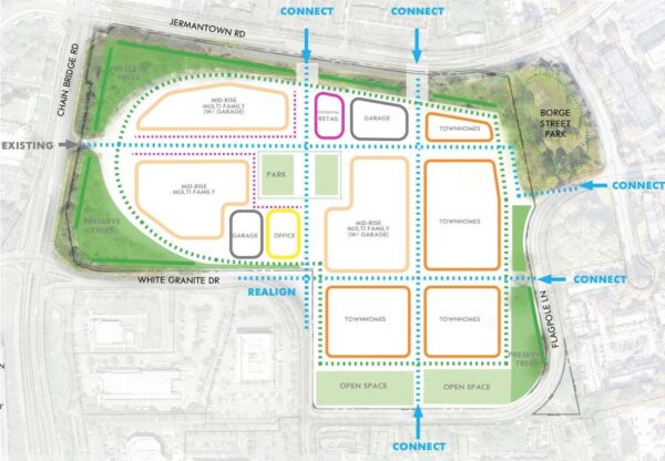
(Updated at noon on 3/31/2023) The Fairfax County Planning Commission has indicated it will support the possibility of redeveloping the AT&T campus in Oakton, but many residents remain concerned about increased density and traffic.
At a meeting last Thursday (March 23), the commissioners took a unanimous, preliminary vote to prioritize a review of the redevelopment of a 33-acre tree-lined site right off Chain Bridge Road in Oakton.
This comes as the county considers dozens of nominations submitted last fall for land use changes as part of its ongoing Site-Specific Plan Amendment (SSPA) process.
The current proposal for 3033 Chain Bridge Road would convert it into “residential mixed-use development” with a mix of market-rate, affordable, and senior housing, along with office space and “community-serving” retail, restaurants and grocery stores.
The campus and 440,000-square-foot main building on the site were first constructed in 1981 to act as AT&T’s corporate offices. While the building was once nearly fully occupied, the workforce assigned to the campus had dwindled even before 2020, but the pandemic accelerated the trend.
The building is now less than 10% occupied and there are about 1,150 unused parking spots taking up close to 50% of the site, Cooley LLP lawyer Mark Looney told the commission on behalf of EYA, the development partner of the property owner.
(Correction: The article previously identified EYA as the property owner as well as the developer. County records identify the owner as Oakton NLA LLC.)
AT&T sold the site in 2013, but still leases the building. The campus also has a large open space, a central lawn, and “stands of mature trees.”
The property’s current underuse, deteriorating physical condition, the neighborhood’s need for amenities, and location near I-66 makes it appealing for redevelopment, the developer argues.
The proposal calls for an “appropriately-scaled mixed-use neighborhood destination” with townhomes, several mid-rise multifamily residential developments, parking garages, and space for office and retail uses. It also seeks to maintain open, park, and tree-lined spaces.
The county’s comprehensive plan currently says any further development on the site “should be within the approved intensity and compatible with existing development,” meaning the AT&T building, though the area to the immediate south has an option for mid-rise multifamily housing.
While EYA’s proposal aligns with the county’s goal of increasing housing, a number of residents who spoke at the meeting shared their concerns that adding such a large development would overwhelm the neighborhood.
Increased traffic, pedestrian safety, overcrowding of schools, and the continuing loss of open space and trees were repeatedly brought up. Read More

