Email signup
A preliminary flood insurance map shows areas in Fairfax County of potential concern (via FEMA)

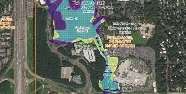
The parts of Fairfax County most at risk for flooding have shifted over the past 10-plus years, according to new flood insurance maps that are currently available for public review and appeals.

“Residents, business owners and other community partners are encouraged to review the updated maps to learn about local flood risks and potential future flood insurance requirements,” the Federal Emergency Management Agency said in a news release on Wednesday (April 27).

FEMA opened up a 90-day review process on April 22 for the preliminary maps. Last updated over a decade ago, the Flood Insurance Rate Maps provide information on flood elevations and what areas are designated particularly hazardous, potentially affecting who should buy flood insurance.

“Across the county, about 995 structures are expected to be mapped out of the regulatory floodplain and 510 mapped in,” FEMA spokesperson Charlie Elison told FFXnow in an email.

According to FEMA, structures that will now fall into the regulatory floodplain include “north and south of Huntley Meadows Park, along Tripps Run and Lake Barcroft, and along Lake Audubon” in Reston.

Clusters being mapped out of the regulatory floodplain are along Cub Run near Cub Run Stream Valley Park in Centreville, Accotink Creek near Davison Army Airfield, the upper reaches of Pohick Creek and its tributaries, and Wolftrap Creek.

“It is important for residents to know that many of our flood insurance claims during a disaster come from outside the Special Flood Hazard Area, so even if people are mapped out of the regulatory floodplain, they are still at risk of flooding,” Elison wrote. “We encourage everyone to call their insurance agent to get information on the best way to protect their properties from flooding.”

The data is a key piece of information that helps people determine flood risks. Virginia also has a Flood Risk Information System that helps property owners and buyers understand their flood insurance rate and consider flood-proofing options.

Per the news release:

Most homeowner’s insurance policies do not cover flooding. There are cost-saving options available for those newly mapped into a high-risk flood zone. Learn more about your flood insurance options by talking with your insurance agent and visiting https://www.floodsmart.gov.

Property owners who see incorrect information that doesn’t affect flood hazard information can submit a written comment. Submit appeals and comments by contacting floodplain administrator Dipmani Kumar at Dipmani.Kumar@fairfaxcounty.gov.

“They may submit an appeal if they perceive that modeling or data used to create the map is technically or scientifically incorrect,” FEMA said, noting an appeal must include technical information, such as hydraulic or hydrologic data, to support the claim.

Changes from the current maps are available at https://arcg.is/09vTC4.

The county’s new Flood Insurance Rate Map is slated to become effective in May 2023.

0 Comments
×

Subscribe to our mailing list