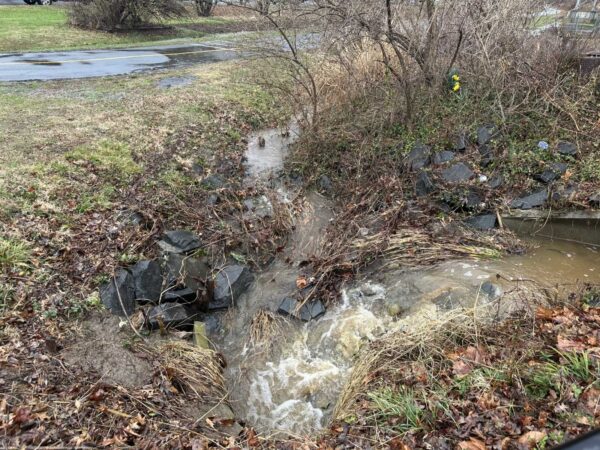
A Flood Watch is now in effect for the D.C. area, including Fairfax County.
The National Weather Service describes the chances of “slow-moving showers and thunderstorms” this afternoon into the early evening as “likely.”
Issued at 11:26 a.m., the alert will be in place until 8 p.m.
“A few inches of rain is possible in a short amount of time as a result, and may cause rapid rises of water on creeks, streams, urban and poor drainage areas, and in other flood-prone locations,” the NWS says.
Rain has become more plentiful in recent days after the D.C. region experienced drought conditions earlier this year. A storm on Wednesday (July 5) brought at least 1-4 inches of rain, according to the NWS, contributing to flooding and power outages, particularly in the central part of Fairfax County.
The full alert is below:
…FLOOD WATCH IN EFFECT UNTIL 8 PM EDT THIS EVENING…
* WHAT…Flash flooding caused by excessive rainfall is possible.
* WHERE…Portions of DC, Maryland, and northern Virginia, including the following areas: in DC, District of Columbia. In Maryland, Anne Arundel, Carroll, Central and Southeast Howard, Central and
Southeast Montgomery, Charles, Frederick MD, Northern Baltimore, Northwest Harford, Northwest Howard, Northwest Montgomery, Prince Georges, Southeast Harford, and Southern Baltimore. In northern Virginia, Arlington/Falls Church/Alexandria, Central and Southeast Prince William/Manassas/Manassas Park, Eastern Loudoun, Fairfax, Northwest Prince William, Stafford and Western Loudoun.* WHEN…Until 8 PM EDT this evening.
* IMPACTS…Excessive runoff may result in flooding of rivers, creeks, streams, and other low-lying and flood-prone locations.
* ADDITIONAL DETAILS…
– A couple rounds of slow-moving showers and thunderstorms are likely this afternoon into this evening. A few inches of rain is possible in a short amount of time as a result, and may cause rapid rises of water on creeks, streams, urban and poor drainage areas, and in other flood-prone locations.

Fairfax County is pushing forward on a program that could have the county government split the bill for private stormwater projects with property owners.
Flooding doesn’t end at the property line and the Local Stormwater Management Assistance Fund aims to help boost stormwater management on private property. At an environmental committee meeting of the Board of Supervisors on April 25, staff presented an update on the program.
“This is a good example of how: even when we say everything is private, it’s your responsibility, at the end of the day, if things fall apart, they somehow end up in our lap,” said Hunter Mill District Supervisor Walter Alcorn.
The pilot divided the cost-sharing based on the percentage of property that’s public versus private. For a stormwater issue where most of the drainage is on public land, the county will pay most of the bill, whereas for an issue where the drainage is mostly on private property, the owners would pay the majority.

The initial budget for the program would be $250,000, with up to $7,000 allowed for each project applying to the fund. Staff said no more than 30 projects could be funded per year through the program, butwith the current eligibility restrictions, even 30 projects was somewhat optimistic.
The county is currently finishing up a pilot program that included the Millwood Pond, Virginia Center or Nutley, Green Trails and Gunston Corner facilities.
The county has signed an agreement with the Millwood Pond owners but determined no maintenance was needed. A “complex” maintenance project at Nutley has been completed, while one at Green Trails is under construction. Negotiations on an agreement for the Gunston Corner pond are still underway.
After the pilot finishes, staff will return to the Board of Supervisors’ environmental committee.

A major winter storm is headed for the D.C. area, just in time to disrupt holiday travel.
While the snow and ice created by a “bomb cyclone” is expected to stay further west, Fairfax County and the rest of the D.C. area are in for a downpour, according to the National Weather Service.
The NWS has already issued a Flood Watch for the region that’s set to be in effect from 11 a.m. tomorrow (Thursday) to 1 a.m. Friday (Dec. 23).
…FLOOD WATCH IN EFFECT FROM THURSDAY MORNING THROUGH LATE THURSDAY
NIGHT…* WHAT…Flooding caused by excessive rainfall is possible.
* WHERE…DC and portions of Maryland and northern Virginia, including the following areas: District of Columbia. In Maryland, Anne Arundel, Cecil, Central and Southeast Howard, Central and Southeast Montgomery, Prince Georges, Southeast Harford and Southern Baltimore. In northern Virginia, Arlington/Falls Church/Alexandria, Fairfax and Prince William/Manassas/Manassas Park.
* WHEN…From Thursday morning through late Thursday night.
* IMPACTS…Excessive runoff may result in flooding of rivers, creeks, streams, and other low-lying and flood-prone locations. Flooding may occur in poor drainage and urban areas.
* ADDITIONAL DETAILS…
– Moderate rainfall is expected Thursday into Thursday evening, with rainfall totals of one to two inches. This may lead to isolated instances of flooding, especially in urban and poor drainage areas.
The Virginia Department of Transportation advises those planning to travel for Christmas to leave today instead of tomorrow, particularly if they’re going to be in the western half of the state.
“Crews have already begun pretreating and brining the roads and will begin deploying trucks early Thursday morning to treat roads as needed,” VDOT said in an advisory.
The department also warned that temperatures are expected to plummet into Friday, meaning fallen rain might refreeze into ice. Forecasts indicate this weekend may be the coldest Christmas in decades.
#NOVA fam – take 70 seconds to get the #WinterWeather update you need before #WinterTravel! We've got precipitation and LOW temps headed our way soon 🥶 @VaDOT @NWS_BaltWash @VDEM pic.twitter.com/O9sUTMNyul
— VDOT Northern VA (@VaDOTNOVA) December 21, 2022

(Updated at 5:05 p.m.) An October weekend once filled with fall events is starting to clear out, as Fairfax County braces for Hurricane Ian.
The storm that devastated Florida after making landfall on Wednesday (Sept. 28) is expected to weaken as it heads north, but its rain and winds could still prove dangerous, the Fairfax County Department of Emergency Management and Security (DEMS) warns.
According to the department, remnants of Hurricane Ian are projected to arrive tonight (Friday), bringing scattered flooding and strong winds:
- Scattered localized flooding is possible from rain. Overall, we are not expecting significant flooding impacts from this event. The rainfall totals are expected to be between 1″-2″ with a high end of 3″ over the three day period of Friday through Sunday. A rumble of thunder may enter the area early Saturday morning, but no significant thunderstorm threat is expected.
- Winds will be sustained at 15-20 mph with gusts between 20-30 mph throughout the weekend.
- Tidal anomalies of 1-2 feet are possible, but no significant tidal flooding for Fairfax County is expected.
Gov. Glenn Youngkin declared a State of Emergency earlier this week, giving the state authority to mobilize resources in preparation for the storm.
Remnants of #HurricaneIan expected to impact #FairfaxCounty Friday – Sunday (Sept. 30-Oct. 2) w/potential of up to 3 inches of rain. Localized flooding possible. #FCFRD & county agencies will continue to monitor Ian and provide updates as needed. More: https://t.co/KQQQsuY3Sf pic.twitter.com/1latw5DiA4
— Fairfax County Fire/Rescue (@ffxfirerescue) September 29, 2022
Several events planned across the county for tomorrow (Saturday) have already been canceled or rescheduled, with organizers citing the impending inclement weather. Others are still monitoring conditions before making a determination.
The McLean Project for the Arts pulled the plug on its annual MPAartfest on Wednesday, though the 2022 McLean 5K is still on for now.
“This is a rain or shine event, we have no plans to cancel,” McLean Community Center General Programs Director Mike Fisher said. “If we do cancel, that decision will be made in the moment as a result of on the ground conditions at the event site.”
Reston Community Center’s first-ever Silent Dance Party at Reston Station has been postponed to 5 p.m. on Oct. 9, while Reston Association announced yesterday (Thursday) that its popular Reston Community Yard Sale has moved to next Saturday, Oct. 8.
This morning, the Town of Vienna officially canceled tomorrow’s Oktoberfest, which drew more than 35,000 visitors last year. The Fall Native Plant Sale has been bumped to Oct. 8.
In lieu of the town’s official Oktoberfest, the Vienna Moose Lodge (9616 Courthouse Road) has teamed up with Caboose Brewing Company to host indoor festivities with draft beer and pretzels from noon to 9 p.m.
Both Fairfax County Park Authority events set for tomorrow have been altered. Bug Fest at Lewinsville Park in McLean has been postponed to Oct. 22, but Buktertoberfest at Burke Lake Golf Course has been canceled.
In Fairfax City, the Out of Darkness Walk to raise awareness about suicide and mental health impacts is currently still a go, but the American Foundation for Suicide Prevention says it will provide an update by 5 p.m. if that changes.
Map via NOAA

Fairfax County is considering making all existing and future development built to lessen flooding risks from huge, 100-year event storms, as opposed to a 10-year storm.
The risk of flooding in the county is rising due to climate change, staff told the Fairfax County Board of Supervisors environmental committee late last month. While preventing flooding is impossible, its impact can be mitigated, they said.
Under the staff proposal, the county would require all future development to have proper drainage, pipe conveyance, and safety measures to accommodate a 100-year storm event adjusting for climate change.
The proposal is part of the county’s Community-wide Energy and Climate Action Plan, which was approved last September.
A “100-year storm event” is defined by the U.S. Geological Survey as one that “statistically has a 1-percent chance of occurring in any given year.” It brings about 8 inches of rain over a 24-hour period, according to the latest data.
With climate change expected to produce stronger storms and increased flooding, that figure is likely to be adjusted in the future.
Part of the proposal is that new development would be required to be built to adjust for predicted sea level rise and severe weather risks.
Currently, all developments must accommodate a 10-year storm event, which is the 10% chance of 4.5 inches of rain falling in a 24-hour period.
In the last decade, Fairfax County and the D.C. region have experienced several flood-level storms. In 2011, Tropical Storm Lee dumped 7 inches of rain in three hours. In 2019, nearly 5 inches came down in some parts of the county, and just last month, nearby Montgomery County experienced extreme flooding from more than 5 inches of rain.
For existing structures, like houses, the plan is to “mitigate” flooding through regulation, public infrastructure projects, and recovery programs.
“There’s no right answer about what flood risk is acceptable because there’s no such thing as zero risk from flood,” Department of Public Works and Environmental Services Deputy Director Ellie Codding said. “What we can do is design infrastructure to a reasonable point and to educate the public and be ready with resources for recovery.”
With water typically passing through residential properties from upstream, a channel or flood path blocked by a fence, debris or an unpermitted addition can exacerbate flooding, preventing water from flowing where it was designed to go.
Almost all flooding in the county happens in basements, Codding said, so understanding and preventing this is a shared responsibility of residents and the county.
“With participation from residents and businesses, the county alone can’t achieve a meaningful level of flood risk reduction,” she said.
Of course, all of this will come with a cost, one that might be supplemented by increased taxes.
While board members agreed with the overall assessment, several noted that educating homeowners will be an important and more cost-effective component.
Chairman Jeff McKay said homeowners associations or community groups that own and manage stormwater facilities and common areas (like ponds) may not know how to maintain those.
“I’m increasingly concerned about the smaller subdivisions and lack of information, assistance, and oversight to even maintain stormwater facilities that they put in with their development,” McKay said.
Braddock District Supervisor James Walkinshaw noted that some responsibility needs to fall on contractors, who might be doing home renovations or repairs. They are either not educated themselves on good practices or not passing that knowledge on to their clients.
With the board’s consent, county staff are expected to present a “proof-of-concept” study with cost estimates next spring, followed by a flood mitigation plan later in 2023.

Fairfax County and areas nearby are under a Severe Thunderstorm Watch this evening.
The National Weather Service issued a Flood Watch earlier today (Monday), cautioning flooding may occur this evening, and a Severe Thunderstorm Watch is in effect until 10 p.m.
“Excessive runoff may result in flooding of rivers, creeks, streams, and other low-lying and flood-prone locations,” the Flood Watch reads. “Afternoon to evening showers and thunderstorms may produce very heavy rainfall capable of flash flooding. This could include multiple rounds of storms which would enhance the flood risk. Rainfall rates may reach 1 to 2 inches per hour, locally higher in spots. The D.C. and Baltimore metros will be the most susceptible given recent heavy rainfall the past couple of weeks.”
The National Weather Service advises residents to monitor forecasts and be prepared in case of flash floods.
Remember: when thunder roars, go indoors! #FCFRD #weather RT @ReadyFairfax: [1:48 PM] Severe Thunderstorm Watch has been issued until 10 PM this evening. pic.twitter.com/CpSsxhjLaB
— Fairfax County Fire/Rescue (@ffxfirerescue) July 18, 2022

A Flood Watch has been issued for Fairfax County and the rest of the D.C. area.
The alert will be in effect from 11 p.m. today (Friday) through 2 p.m. tomorrow (Saturday), according to the National Weather Service, which warns that “excessive” rainfall may lead to flash flooding.
Rain levels are expected to range from 1 to 7 inches, depending on the exact location.
Here is more from the NWS:
* WHEN…From 11 PM EDT this evening through Saturday afternoon.
* IMPACTS…Excessive runoff may result in flooding of rivers, creeks, streams, and other low-lying and flood-prone locations.
* ADDITIONAL DETAILS…
– Showers are expected with scattered thunderstorms late this evening into midday Saturday. Average rainfall amounts around 1 to 3 inches are expected, but localized amounts around 4 to 7 inches in heavier showers and thunderstorms. Rainfall amounts around 1 to 3 inches within an hour or two are possible in areas where the heaviest rainfall occurs. The best chance for the heaviest rainfall will be overnight into Saturday morning.
A slow moving front will lead to increasing chances for showers and thunderstorms through this evening. Showers will have the potential to produce periods of moderate and heavy rainfall and may lead to scattered instances of flash flooding this evening and into Saturday. pic.twitter.com/TnNDOFPW86
— NWS Baltimore-Washington (@NWS_BaltWash) July 8, 2022

Updated at 2:25 p.m. — The Flood Watch has been extended to 5 a.m. tomorrow (Thursday), per Fairfax County.
Earlier: A Flood Watch is on the horizon for much of the D.C. area, including Fairfax County.
The National Weather Service issued an alert at 5:20 a.m. today (Wednesday), warning that storms may lead to flash flooding starting around 3 p.m. The watch is currently set to remain in effect until 3 a.m. tomorrow.
Here is more from the alert:
* IMPACTS…Excessive runoff may result in flooding of rivers, creeks, streams, and other low-lying and flood-prone locations. Creeks and streams may rise rapidly out of their banks. Flooding may occur quickly in poor drainage and urban areas.
* ADDITIONAL DETAILS…
– Multiple rounds of scattered to numerous showers and thunderstorms are likely this afternoon and tonight. The most likely time period for thunderstorms producing heavy rain and potential flash flooding is this evening, but thunderstorms could develop as early as this afternoon, and may linger well into the night. Several inches of rain is possible in a short period of time, which would cause rapid rises of water.
Despite the risk of rain, the region’s usual July heat and humidity are out in full force, with temperatures potentially reaching the low 90s. The heat index is expected to peak near 100 degrees, according to the Fairfax County Fire and Rescue Department.
“If possible, make sure to stay hydrated and in shaded or air-conditioned places. Also check on your friends and neighbors,” the department said.
Symptoms of heat-related illnesses include fainting or dizziness, muscle cramps, and nausea or vomiting.
[7/6/22 at 8:26 AM] A Flood Watch is in effect from 3 PM this afternoon through late tonight as multiple rounds of scattered showers & thunderstorms are likely. The most
likely time period for thunderstorms producing heavy rain & potential flash flooding is this evening. #VaWx pic.twitter.com/LBziVn1KYE— Ready Fairfax (@ReadyFairfax) July 6, 2022
Image via National Weather Service/Twitter

As Fairfax County finalizes its first-ever plan to address the future effects of climate change, community members can see how the phenomenon already affects them with a newly released interactive map.
Launched last week, the climate map depicts heat and flooding data that can be viewed in conjunction with maps of the county’s population and infrastructure, including roads, utilities, and public facilities.
“The Fairfax County interactive climate map is a dynamic tool showcasing some of the best available data we have to date on climate impacts in our community,” Matt Meyers, the climate planning division director for the Fairfax County Office of Environmental and Energy Coordination, said. “The map is meant to inform and empower county residents, business owners, and community leaders to actively prepare for and participate in resilience efforts on a local level.”
The map offers a clear illustration of the heat island effect, showing that average daytime temperatures are higher in more populated and developed areas along major highways, like Tysons, Reston, the Fair Lakes and Fair Oaks area, and the Route 1 corridor.
Flooding appears to be most intense in the southeast part of the county, with waters from the Potomac River and Occoquan Bay overflowing onto Belle Haven, Lorton, Mason Neck, and Fort Belvoir. If sea levels rise a foot, Mason Neck will noticeably shrink. If they rise three feet, the Route 1 ramps to I-495 at the Alexandria border will be submerged.

The OEEC developed the map using information gathered through its Resilient Fairfax initiative, which started last year to establish a Climate Adaptation and Resilience Plan intended to reduce and prepare the county for the damages that will come with a rapidly warming Earth.
So far, the initiative has produced:
- A Climate Projections Report, which found that rising greenhouse gas emissions could fuel a significant increase in days with temperatures over 95 degrees
- An audit analyzing how well the county’s existing policies and facilities take climate change into account
- A draft Climate Vulnerability and Risk Assessment, which looked at which residents, services, and facilities are most vulnerable to the impacts of climate change
- A draft Climate Adaptation and Resilience Plan that recommended creating a fund for climate-related county projects, among other proposals
The Climate Adaptation and Resilience Plan will be finalized and presented to the Board of Supervisors for acceptance this fall, according to OEEC spokesperson Ali Althen.
The climate map uses the same data that went into the projections report and risk assessment, but it’s narrower in scope, focusing on current flood and heat information with some indicators of future conditions, such as “projected sea level rise and coastal storm surge,” the OEEC says.
With marginalized communities facing the most severe consequences from climate change, the map also incorporates data from the county’s Vulnerability Index, which scored different areas based on residents’ income, education, homeownership, and other socioeconomic factors.
The OEEC says it’s important for residents to understand what climate hazards are in store for the county so they can get involved in efforts to address those impacts. In Belle Haven, for instance, the U.S. Army Corps of Engineers has already proposed building a wall to mitigate flooding.
“Awareness is the first step toward climate readiness, and we hope this tool will allow users to grow in their understanding of the risks facing Fairfax County now and in the years to come,” Meyers said.

Fairfax County is under a Flood Watch until midnight.
The National Weather Service issued the watch this morning, noting flash flooding caused by excessive rainfall is possible after 3 p.m.
Showers and thunderstorms are expected later this afternoon into the evening, according to the National Weather Service. There will be heavy rainfall at times, with predicted rainfall amounts of 1 to 3 inches within the span of a couple of hours, according to the Flood Watch.
A Hazardous Weather Outlook in the county states damaging winds and hail are also possible.
Showers and thunderstorms are likely, mainly between 3 PM and 11
PM. A Flash Flood Watch for potential flash flooding is in effect
near and west of Interstate 95 during this time. Isolated
instances of flooding can`t be ruled out further east.In addition, a few storms may become severe with damaging wind
gusts and large hail. An isolated tornado can`t be ruled out.
The #Flood Watch for potential flash flooding this afternoon and evening has been expanded eastward into the I-95 corridor. Heavy #rain from thunderstorms may lead to rapid rises of water in creeks, streams, and in poor drainage areas. pic.twitter.com/MtfzQDadcQ
— NWS Baltimore-Washington (@NWS_BaltWash) June 22, 2022
[6/22/22 at 1:30 PM] A Flood Watch is in effect this afternoon until 11 PM. Heavy rain from thunderstorms may lead to rapid rises of water in creeks, streams, and in poor drainage areas. Please stay weather aware. #VaWx pic.twitter.com/oSgtmhUVd0
— Ready Fairfax (@ReadyFairfax) June 22, 2022