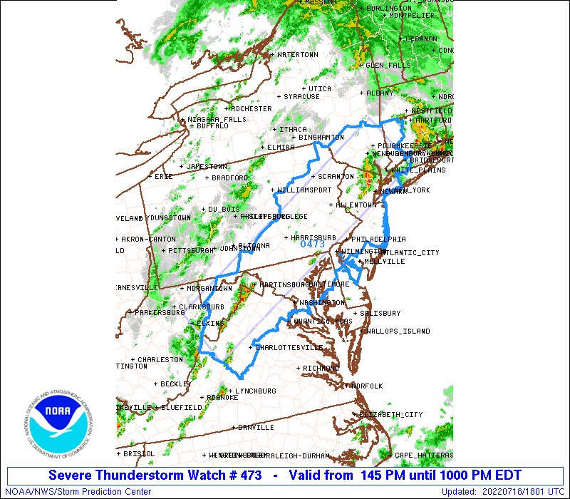
Fairfax County and areas nearby are under a Severe Thunderstorm Watch this evening.
The National Weather Service issued a Flood Watch earlier today (Monday), cautioning flooding may occur this evening, and a Severe Thunderstorm Watch is in effect until 10 p.m.
“Excessive runoff may result in flooding of rivers, creeks, streams, and other low-lying and flood-prone locations,” the Flood Watch reads. “Afternoon to evening showers and thunderstorms may produce very heavy rainfall capable of flash flooding. This could include multiple rounds of storms which would enhance the flood risk. Rainfall rates may reach 1 to 2 inches per hour, locally higher in spots. The D.C. and Baltimore metros will be the most susceptible given recent heavy rainfall the past couple of weeks.”
The National Weather Service advises residents to monitor forecasts and be prepared in case of flash floods.
Remember: when thunder roars, go indoors! #FCFRD #weather RT @ReadyFairfax: [1:48 PM] Severe Thunderstorm Watch has been issued until 10 PM this evening. pic.twitter.com/CpSsxhjLaB
— Fairfax County Fire/Rescue (@ffxfirerescue) July 18, 2022
A Flood Watch has been issued for Fairfax County and the rest of the D.C. area.
The alert will be in effect from 11 p.m. today (Friday) through 2 p.m. tomorrow (Saturday), according to the National Weather Service, which warns that “excessive” rainfall may lead to flash flooding.
Rain levels are expected to range from 1 to 7 inches, depending on the exact location.
Here is more from the NWS:
* WHEN…From 11 PM EDT this evening through Saturday afternoon.
* IMPACTS…Excessive runoff may result in flooding of rivers, creeks, streams, and other low-lying and flood-prone locations.
* ADDITIONAL DETAILS…
– Showers are expected with scattered thunderstorms late this evening into midday Saturday. Average rainfall amounts around 1 to 3 inches are expected, but localized amounts around 4 to 7 inches in heavier showers and thunderstorms. Rainfall amounts around 1 to 3 inches within an hour or two are possible in areas where the heaviest rainfall occurs. The best chance for the heaviest rainfall will be overnight into Saturday morning.
A slow moving front will lead to increasing chances for showers and thunderstorms through this evening. Showers will have the potential to produce periods of moderate and heavy rainfall and may lead to scattered instances of flash flooding this evening and into Saturday. pic.twitter.com/TnNDOFPW86
— NWS Baltimore-Washington (@NWS_BaltWash) July 8, 2022
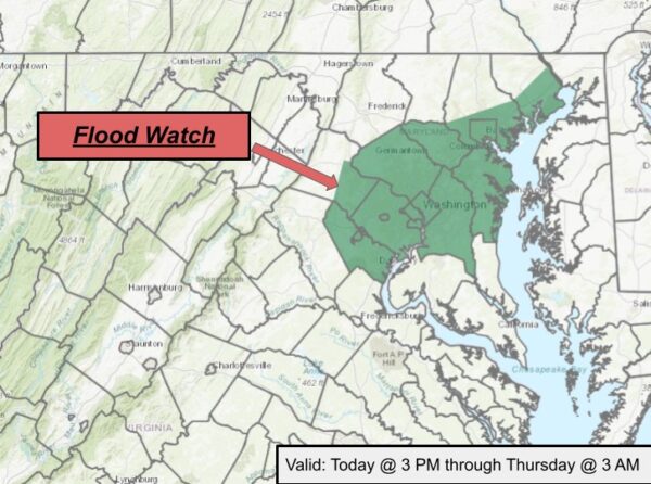
Updated at 2:25 p.m. — The Flood Watch has been extended to 5 a.m. tomorrow (Thursday), per Fairfax County.
Earlier: A Flood Watch is on the horizon for much of the D.C. area, including Fairfax County.
The National Weather Service issued an alert at 5:20 a.m. today (Wednesday), warning that storms may lead to flash flooding starting around 3 p.m. The watch is currently set to remain in effect until 3 a.m. tomorrow.
Here is more from the alert:
* IMPACTS…Excessive runoff may result in flooding of rivers, creeks, streams, and other low-lying and flood-prone locations. Creeks and streams may rise rapidly out of their banks. Flooding may occur quickly in poor drainage and urban areas.
* ADDITIONAL DETAILS…
– Multiple rounds of scattered to numerous showers and thunderstorms are likely this afternoon and tonight. The most likely time period for thunderstorms producing heavy rain and potential flash flooding is this evening, but thunderstorms could develop as early as this afternoon, and may linger well into the night. Several inches of rain is possible in a short period of time, which would cause rapid rises of water.
Despite the risk of rain, the region’s usual July heat and humidity are out in full force, with temperatures potentially reaching the low 90s. The heat index is expected to peak near 100 degrees, according to the Fairfax County Fire and Rescue Department.
“If possible, make sure to stay hydrated and in shaded or air-conditioned places. Also check on your friends and neighbors,” the department said.
Symptoms of heat-related illnesses include fainting or dizziness, muscle cramps, and nausea or vomiting.
[7/6/22 at 8:26 AM] A Flood Watch is in effect from 3 PM this afternoon through late tonight as multiple rounds of scattered showers & thunderstorms are likely. The most
likely time period for thunderstorms producing heavy rain & potential flash flooding is this evening. #VaWx pic.twitter.com/LBziVn1KYE— Ready Fairfax (@ReadyFairfax) July 6, 2022
Image via National Weather Service/Twitter
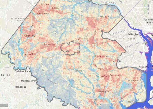
As Fairfax County finalizes its first-ever plan to address the future effects of climate change, community members can see how the phenomenon already affects them with a newly released interactive map.
Launched last week, the climate map depicts heat and flooding data that can be viewed in conjunction with maps of the county’s population and infrastructure, including roads, utilities, and public facilities.
“The Fairfax County interactive climate map is a dynamic tool showcasing some of the best available data we have to date on climate impacts in our community,” Matt Meyers, the climate planning division director for the Fairfax County Office of Environmental and Energy Coordination, said. “The map is meant to inform and empower county residents, business owners, and community leaders to actively prepare for and participate in resilience efforts on a local level.”
The map offers a clear illustration of the heat island effect, showing that average daytime temperatures are higher in more populated and developed areas along major highways, like Tysons, Reston, the Fair Lakes and Fair Oaks area, and the Route 1 corridor.
Flooding appears to be most intense in the southeast part of the county, with waters from the Potomac River and Occoquan Bay overflowing onto Belle Haven, Lorton, Mason Neck, and Fort Belvoir. If sea levels rise a foot, Mason Neck will noticeably shrink. If they rise three feet, the Route 1 ramps to I-495 at the Alexandria border will be submerged.
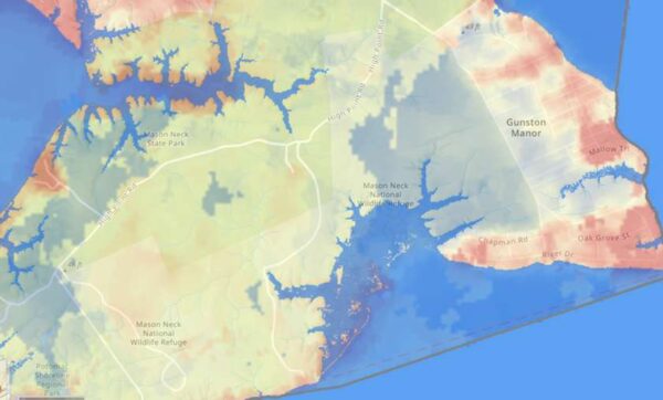
The OEEC developed the map using information gathered through its Resilient Fairfax initiative, which started last year to establish a Climate Adaptation and Resilience Plan intended to reduce and prepare the county for the damages that will come with a rapidly warming Earth.
So far, the initiative has produced:
- A Climate Projections Report, which found that rising greenhouse gas emissions could fuel a significant increase in days with temperatures over 95 degrees
- An audit analyzing how well the county’s existing policies and facilities take climate change into account
- A draft Climate Vulnerability and Risk Assessment, which looked at which residents, services, and facilities are most vulnerable to the impacts of climate change
- A draft Climate Adaptation and Resilience Plan that recommended creating a fund for climate-related county projects, among other proposals
The Climate Adaptation and Resilience Plan will be finalized and presented to the Board of Supervisors for acceptance this fall, according to OEEC spokesperson Ali Althen.
The climate map uses the same data that went into the projections report and risk assessment, but it’s narrower in scope, focusing on current flood and heat information with some indicators of future conditions, such as “projected sea level rise and coastal storm surge,” the OEEC says.
With marginalized communities facing the most severe consequences from climate change, the map also incorporates data from the county’s Vulnerability Index, which scored different areas based on residents’ income, education, homeownership, and other socioeconomic factors.
The OEEC says it’s important for residents to understand what climate hazards are in store for the county so they can get involved in efforts to address those impacts. In Belle Haven, for instance, the U.S. Army Corps of Engineers has already proposed building a wall to mitigate flooding.
“Awareness is the first step toward climate readiness, and we hope this tool will allow users to grow in their understanding of the risks facing Fairfax County now and in the years to come,” Meyers said.
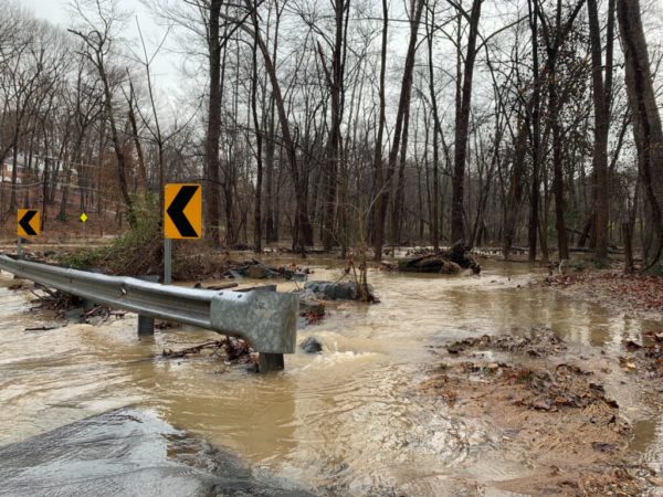
Fairfax County is under a Flood Watch until midnight.
The National Weather Service issued the watch this morning, noting flash flooding caused by excessive rainfall is possible after 3 p.m.
Showers and thunderstorms are expected later this afternoon into the evening, according to the National Weather Service. There will be heavy rainfall at times, with predicted rainfall amounts of 1 to 3 inches within the span of a couple of hours, according to the Flood Watch.
A Hazardous Weather Outlook in the county states damaging winds and hail are also possible.
Showers and thunderstorms are likely, mainly between 3 PM and 11
PM. A Flash Flood Watch for potential flash flooding is in effect
near and west of Interstate 95 during this time. Isolated
instances of flooding can`t be ruled out further east.In addition, a few storms may become severe with damaging wind
gusts and large hail. An isolated tornado can`t be ruled out.
The #Flood Watch for potential flash flooding this afternoon and evening has been expanded eastward into the I-95 corridor. Heavy #rain from thunderstorms may lead to rapid rises of water in creeks, streams, and in poor drainage areas. pic.twitter.com/MtfzQDadcQ
— NWS Baltimore-Washington (@NWS_BaltWash) June 22, 2022
[6/22/22 at 1:30 PM] A Flood Watch is in effect this afternoon until 11 PM. Heavy rain from thunderstorms may lead to rapid rises of water in creeks, streams, and in poor drainage areas. Please stay weather aware. #VaWx pic.twitter.com/oSgtmhUVd0
— Ready Fairfax (@ReadyFairfax) June 22, 2022
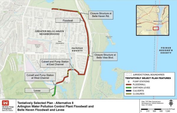
A floodwall in the Belle Haven community could help address Northern Virginia’s flood risk.
A recent study looked at the west bank of the Potomac River from Arlington to Prince William County for solutions to improve resiliency and reduce risks to human health and safety, economic damages, and disruption of critical infrastructure, according to a presentation.
While there were multiple options, the U.S. Army Corps of Engineers found a 5,600-foot-long floodwall in Belle Haven and a 2,500-foot-long floodwall along the Arlington Water Pollution Control Plant on S. Glebe Road were the most feasible.
The total cost of both would be $52.6 million, which includes a 45% contingency on costs, and is estimated to reduce about $66 million in potential damage.
The proposed Belle Haven floodwall would begin around Golf Course Square and extend down Boulevard View before turning west. Then, an earthen levee would be constructed and end near Westview Dog Park, according to the Feasibility Report and Environmental Assessment by Army Corps of Engineers, Baltimore District, and the Metropolitan Washington Council of Governments.
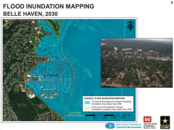
A map of Belle Haven shows that by 2030, the flood risk could extend to the Belle View Shopping Center, Belle Haven Country Club and other parts of the community.
The Belle Haven floodwall would have permanent aesthetic and recreation impacts, as well as stream impacts, according to the presentation. The floodwall would be about 6 feet tall on average.
During construction, there would also be temporary stream impacts. Mitigation would be required for permanent stream impacts.
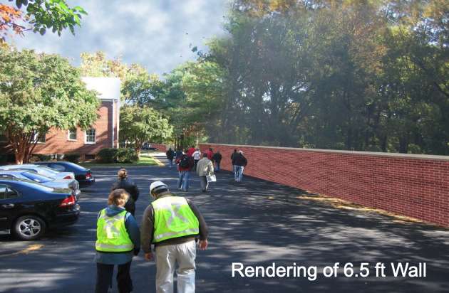
The public can comment on the study through Thursday, June 30, by emailing the project team at DC-Metro-CSRM-Study@usace.army.mil. The Corps of Engineers will respond to comments and revise the report between July and September, determing if this is the preferred option by November.
After further study, design — which hasn’t been funded yet — wouldn’t begin on the project until at least 2024.
The study was conducted as Northern Virginia has seen damaging storms over the years, to include the Chesapeake and Potomac Hurricane of 1933, Hurricane Agnes (1972), Hurricane Fran (1996), Nor’easter (1998), Hurricane Floyd (1999), Hurricane Isabel (2003), Hurricane Irene (2011) and Hurricane Sandy (2012).
Hurricane Isabel resulted in extreme water levels and caused millions of dollars of damage to residences, businesses and critical infrastructure, according to the study.
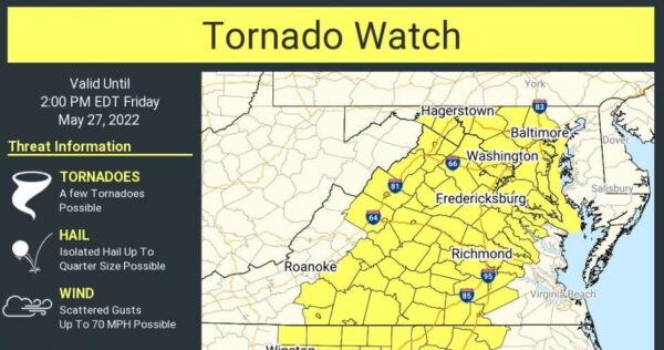
(Updated at 12:55 p.m.) Tornado and storm warnings briefly usurped earlier weather alerts for Fairfax County as the National Weather Service noted potential dangers and hazards across the region.
“Damaging winds will cause some trees and large branches to fall. This could injure those outdoors, as well as damage homes and vehicles,” NWS said in a Severe Thunderstorm Warning alert. “Roadways may become blocked by downed trees. Localized power outages are possible. Unsecured light objects may become projectiles.”
An NWS Baltimore-Washington news feed noted just before noon that a Tornado Warning was in effect for parts of Reston and Great Falls until 12:15 p.m. today (Friday). A watch means tornadoes are possible, whereas warnings mean that they are spotted or indicated by radar.
Tornado Warning including Reston VA, Potomac MD and North Potomac MD until 12:15 PM EDT pic.twitter.com/X1NvEinicy
— NWS Baltimore-Washington (@NWS_BaltWash) May 27, 2022
Some storm damage in my neighbors backyard and up the street in Herndon, VA. As this line moves east, make sure you’re inside and sheltering until it moves through. pic.twitter.com/2iZLAhJqg7
— Alex Liggitt (@7NewsAlex) May 27, 2022
Fairfax County and surrounding areas were also subject to a Severe Thunderstorm Warning until 12:30 p.m. today.
Previously, the National Weather Service issued a Tornado Watch around 6:20 a.m. today that’s in effect until 2 p.m. for Fairfax County and the D.C. region.
Tornadoes, damaging wind gusts and large hail are possible, the NWS said in the earlier alert.
The NWS Baltimore-Washington said on Twitter that scattered gusts could possibly reach 70 mph.
The NWS also issued a Flood Watch at 4:33 a.m. for the county and surrounding areas from 11 a.m. through 11 p.m. today. A NWS meteorologist warned that flash flooding is possible due to excessive rainfall.
“Multiple rounds of thunderstorms producing heavy rainfall may lead to scattered instances of flash flooding,” the NWS said.
A Tornado Watch has been issued for parts of District of Columbia, Maryland, North Carolina, Virginia and West Virginia until 2 PM EDT. pic.twitter.com/OG1C3MbdvG
— NWS Baltimore-Washington (@NWS_BaltWash) May 27, 2022
Due to the storm risks, the county is under a Hazardous Weather Outlook, per the Fairfax County Office of Emergency Management:
Multiple rounds of showers and thunderstorms are likely starting this morning and continuing through this evening. Localized rainfall totals of 1 to 3 inches are expected, though locations that experience multiple rounds of thunderstorms could exceed 3 inches.
If you’re driving, don’t pass through flooded roads. Turn around, don’t drown. Also, keep children away from creeks and streams that may rise rapidly.
⚠️🌩️🌪️Severe thunderstorms are possible today with the potential for damaging wind gusts, tornadoes, large hail, and flash flooding. Multiple rounds of storms are expected. The greatest risk will be this afternoon/evening. A Flood Watch and Tornado Watch have been issued. #VaWx pic.twitter.com/0WRS1sETgm
— Ready Fairfax (@ReadyFairfax) May 27, 2022

Updated at 7:25 p.m. — A Flood Warning has now been issued for Fairfax County, with an additional half to 1.5 inches of rain possible until 1:15 a.m. Monday. The Severe Thunderstorm Warning has also been extended to 8 p.m.
Earlier: A Severe Thunderstorm Warning is in effect for Fairfax County.
The National Weather Service issued the alert shortly after 5 p.m., warning of 60 mph wind gusts and quarter-sized hail:
IMPACT…Damaging winds will cause some trees and large branches to fall. This could injure those outdoors, as well as damage homes and vehicles. Roadways may become blocked by downed trees. Localized power outages are possible. Unsecured light objects may become projectiles.
Moving eastward, the storm has already made its way through Herndon and just passed the Town of Vienna, bringing a couple minutes of intense rain, thunder, and hail that ended as quickly as it began.
515p: Storm in northern Fairfax County has expanded and intensified prompting warning. Time to head inside McLean, Tysons, Arlington, Bethesda, NW DC. Updates: https://t.co/XDnWA1T1pc pic.twitter.com/GIRUbjs1ds
— Capital Weather Gang (@capitalweather) May 22, 2022
Hail in Vienna @capitalweather pic.twitter.com/zpStFsWRvp
— Adrian Deveny (@AdrianDeveny) May 22, 2022
Strong storm, dime sized hail in Oakton. @dougkammerer @capitalweather pic.twitter.com/4ZjccbA40v
— Jason Maturo (@JasonMaturo) May 22, 2022
This is the second thunderstorm with hail to hit the D.C. area within the past week, and it came a day after temperatures hit a high of 92 degrees, according to NWS data.
While the warning is set to end at 6 p.m., a Severe Thunderstorm Watch is currently in effect until 9 p.m.
⚠️A Severe Thunderstorm Watch has been issued until 9 PM for Fairfax County. Keep an eye on the sky especially if you are outside this afternoon and evening. #VaWx pic.twitter.com/Y9RFYZc9So
— Ready Fairfax (@ReadyFairfax) May 22, 2022

The National Weather Service has issued a Flood Watch for Fairfax County and the rest of the D.C. area.
The alert is set to take effect at 5 p.m. today (Friday) and last until 2 a.m. tomorrow (Saturday), though current forecasts indicate that rain is likely to continue throughout the weekend.
“Widespread rainfall totals of 1-3 inches are expected through tonight,” the NWS said. “This may lead to localized instances of flooding.”
Here is more from the alert:
…FLOOD WATCH IN EFFECT FROM THIS AFTERNOON THROUGH LATE TONIGHT…
* WHAT…Flooding caused by excessive rainfall is possible.
* WHERE…DC and portions of Maryland and northern Virginia, including the following areas: the District of Columbia. In Maryland, Anne Arundel, Central and Southeast Howard, Central and
Southeast Montgomery, Northwest Howard, Northwest Montgomery, Prince Georges and Southern Baltimore. In northern Virginia, Arlington/Falls Church/Alexandria, Eastern Loudoun, Fairfax,
Northern Fauquier, Prince William/Manassas/Manassas Park and Western Loudoun.* WHEN…From this afternoon through late tonight.
* IMPACTS…Excessive runoff may result in flooding of rivers, creeks, streams, and other low-lying and flood-prone locations.
The NWS advises continuing to monitor forecasts and staying alert for possible Flood Warnings.
. @NWS has issued a Flood Watch for #FairfaxCounty. Stay #weather aware throughout the day. PLEASE do NOT drive through a flooded roadway! Don't put you, loved ones, or #FCFRD firefighters/paramedics in harms way! #TurnAroundDontDrown pic.twitter.com/h181FOBLEz
— Fairfax County Fire/Rescue (@ffxfirerescue) May 6, 2022
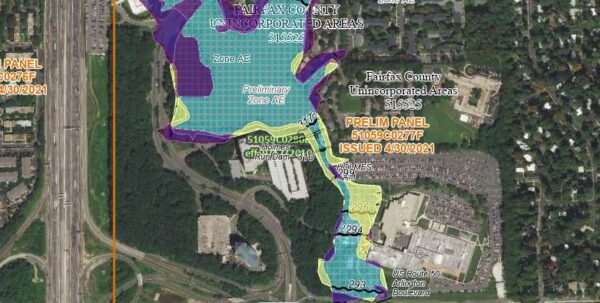
The parts of Fairfax County most at risk for flooding have shifted over the past 10-plus years, according to new flood insurance maps that are currently available for public review and appeals.
“Residents, business owners and other community partners are encouraged to review the updated maps to learn about local flood risks and potential future flood insurance requirements,” the Federal Emergency Management Agency said in a news release on Wednesday (April 27).
FEMA opened up a 90-day review process on April 22 for the preliminary maps. Last updated over a decade ago, the Flood Insurance Rate Maps provide information on flood elevations and what areas are designated particularly hazardous, potentially affecting who should buy flood insurance.
“Across the county, about 995 structures are expected to be mapped out of the regulatory floodplain and 510 mapped in,” FEMA spokesperson Charlie Elison told FFXnow in an email.
According to FEMA, structures that will now fall into the regulatory floodplain include “north and south of Huntley Meadows Park, along Tripps Run and Lake Barcroft, and along Lake Audubon” in Reston.
Clusters being mapped out of the regulatory floodplain are along Cub Run near Cub Run Stream Valley Park in Centreville, Accotink Creek near Davison Army Airfield, the upper reaches of Pohick Creek and its tributaries, and Wolftrap Creek.
“It is important for residents to know that many of our flood insurance claims during a disaster come from outside the Special Flood Hazard Area, so even if people are mapped out of the regulatory floodplain, they are still at risk of flooding,” Elison wrote. “We encourage everyone to call their insurance agent to get information on the best way to protect their properties from flooding.”
The data is a key piece of information that helps people determine flood risks. Virginia also has a Flood Risk Information System that helps property owners and buyers understand their flood insurance rate and consider flood-proofing options.
Per the news release:
Most homeowner’s insurance policies do not cover flooding. There are cost-saving options available for those newly mapped into a high-risk flood zone. Learn more about your flood insurance options by talking with your insurance agent and visiting https://www.floodsmart.gov.
Property owners who see incorrect information that doesn’t affect flood hazard information can submit a written comment. Submit appeals and comments by contacting floodplain administrator Dipmani Kumar at Dipmani.Kumar@fairfaxcounty.gov.
“They may submit an appeal if they perceive that modeling or data used to create the map is technically or scientifically incorrect,” FEMA said, noting an appeal must include technical information, such as hydraulic or hydrologic data, to support the claim.
Changes from the current maps are available at https://arcg.is/09vTC4.
The county’s new Flood Insurance Rate Map is slated to become effective in May 2023.

