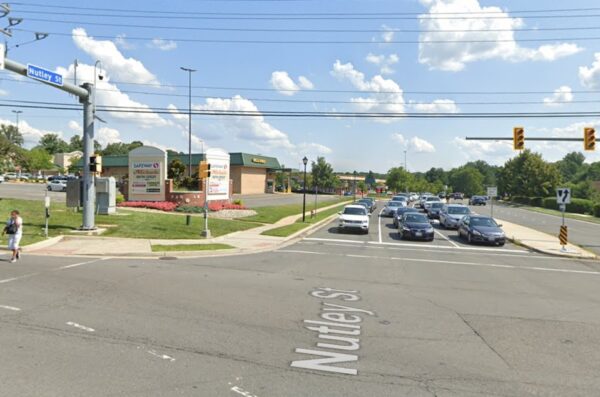
Fairfax County’s vision for a redevelopment of the Pan Am Shopping Center in Merrifield will likely include an emphasis on pedestrian and bicycle connections.
At a virtual community meeting on May 22, the county’s Department of Planning and Development offered a preview of its proposed comprehensive plan amendment to allow multifamily housing at the 25-acre retail center (3089 Nutley Street SW).
Among the draft recommendations, which are being finalized for a staff report expected on June 7, is a provision that the new development blocks be designed to facilitate pedestrian and bicycle access and minimize conflicts between different modes of travel.
In addition to keeping an existing path to the Providence Hall Apartments to the south, county staff have suggested adding a “north-south pedestrian connection” between Route 29 and the three residential buildings proposed by Pan Am owner Federal Realty.
The county is also contemplating recommendations for a shared-use path on the east side of Nutley Street and new or upgraded bus shelters on Nutley and Route 29.
“One of the things that we are trying to do as part of this plan amendment…is to really create a sense of place at the Pan Am Shopping Center, so that you can have the type of environment where people are being encouraged to walk there and bike there, not just drive there,” county plan development chief Graham Owen said.
The shared-use path will likely be separate from the street, he added after a community member raised concerns about bicycle lanes taking away space from cars on Nutley.
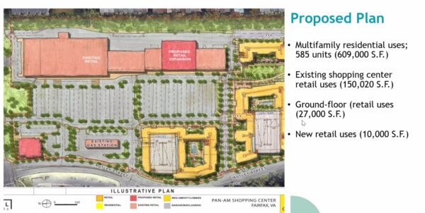
The redevelopment’s potential impact on traffic has been at the forefront of many residents’ minds. An analysis by county transportation staff found that the proposed overhaul would generate 803 more vehicle trips per day than the existing shopping center.
That would be 4,271 fewer trips than what’s possible under the current comprehensive plan, but community members in the meeting lamented that Nutley already has congestion and accessibility issues.
“Coming on Nutley from the [I-66] bridge side, the county needs to improve that. With that new crossroads, it is dangerous,” resident Francis Forgione said. “There’s no lights, and cars don’t stop entering and exiting the freeway…The county needs to somehow make it safe so you can approach from all directions, not just one direction.” Read More
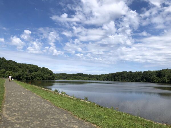
Questions continue to swirl around Lake Accotink Park’s long-term future, but that hasn’t stopped Fairfax County from pursuing some needed facility upgrades.
This Saturday (June 3), the Fairfax County Park Authority will celebrate the completion of its new Accotink Creek Crossing, a 320-foot-long concrete trail and 325-foot, elevated pedestrian bridge that closes 3.9-mile trail loop around the North Springfield park.
Coinciding with National Trails Day, the ribbon-cutting ceremony at 8:30 a.m. will be followed by a full day of outdoor activities, including nature and history hikes and a trail bicycle ride.
Under construction since last summer, the new crossing has improved the conditions and slope of the trail at the Lake Accotink dam outfall, according to the park authority.
“The previous stream crossing at the outfall of the Lake Accotink dam was subject to sudden and frequent flooding, often stranding trail users and tempting them to wade through swiftly moving water,” the authority said. “Additionally, excessive storm damage necessitated the total reconstruction of the trail twice within the last five years.”
The project was funded with just over $3 million from park bonds.
Playground replacement expected this year
Other impending improvements include an overhaul of the park’s playground, which has been out of commission since November after an inspector determined that the aging equipment was unsafe to use.
With $300,000 approved for a replacement, the park authority recently unveiled a design concept showcasing the features planned for the new playground, including a tower structure with a slide, four swings, a climbing net, a bouldering feature, a music feature, and a playhouse.

“In the interest of delivering a functional, safe and enjoyable playground experience as quickly as possible, this particular project was conducted as an in-kind replacement,” meaning it will fit within the footprint of the existing playground, FCPA spokesperson Benjamin Boxer said.
The new equipment is expected to be installed late this summer or by early fall, though the timeline could be revised “as ordering, delivery and installation details are finalized,” according to Boxer.
As the county develops a vision for the park’s future, which might not include a lake, the park authority says it intends to recommend adding a second, larger playground. Read More
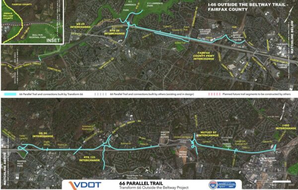
The first segment of the Virginia Department of Transportation’s planned shared-use trail along I-66 has been completed.
State and Fairfax County officials will celebrate the milestone today (Wednesday) with a ribbon-cutting ceremony at 11 a.m., followed by an inaugural bicycle ride or walk on the finished section, which starts east of the Vienna Metro station and extends to Cedar Lane near Merrifield.
The segment includes a tunnel under Nutley Street, one of several below-grade crossings planned for the 11-mile, mostly 10-foot-wide trail being built from Gallows Road in Dunn Loring to Route 29 in Centreville.
More portions are expected to be finished later this month, including a crossing at an I-66 entry ramp at the Nutley Street interchange and a segment from Blake Lane to Route 123 in Oakton.
“The 66 Parallel Trail and new bike and pedestrian access across the I-66 bridges supports VDOT’s commitment to providing multimodal travel options to ‘move more people — not just vehicles,'” VDOT said in a statement to FFXnow.
VDOT’s private partner I-66 Express Mobility Partners (I-66 EMP) and construction contractor FAM Construction built the 66 Parallel Trail — a name chosen by a Fairfax County survey — as part of the Transform 66 Outside the Beltway project, which added 22 miles to the I-66 Express Lanes.
Including sidewalks being added on bridge crossings over I-66, the project will deliver 18 miles of new pedestrian and bicycle facilities, according to VDOT.
The trail’s inclusion in the highway widening project came after a campaign by local pedestrian and bicycling advocates, including the nonprofit Fairfax Alliance for Better Bicycling (FABB).
“The new 66 Trail will significantly improve east-west connectivity for people walking and biking in the corridor that does not exist today,” said former FABB President Sonya Breehey, who’s now the Northern Virginia advocacy manager for the Coalition for Smarter Growth. “The trail opens up the opportunity to walk, bike, roll to the Metro, schools, parks, restaurants, retail, and other places throughout the corridor.”
The design process for the trail was contentious, as cycling advocates pushed to keep it outside the I-66 soundwalls. However, adjacent homeowners objected to giving up part of their backyards, fearing a loss of privacy and green space.
The final design placed approximately three miles directly next to the highway, while about eight miles will be behind a noise barrier or have no noise barrier.
Breehey calls the trail’s placement inside the soundwalls an “unfortunate compromise,” but VDOT mitigated some concerns by elevating some portions above the highway and putting others behind a 50-inch concrete barrier. Read More
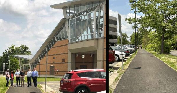
A connection has now been solidified between Herndon Metro station and Van Buren Street.
The Town of Herndon has completed construction of an 800-foot trail for pedestrians and bicyclists that connects the Metro station to Van Buren Street by Worldgate Centre.
“The 800-foot trail provides ready access to Metro for workers in the Worldgate and nearby office complexes,” the Town of Herndon said.
The trail goes live as Bike to Work Day kicks off on Friday (May 19). The Herndon area will have pit stops at the Innovation Center Metro station and the Town Hall Green.
Construction on the project began in September 2022. The project was completed roughly two months ahead of schedule, according to town spokesperson Anne Curtis.
The overall project cost $600,000 for design and construction. It was funded through a combination of town funds as well as funds from Fairfax County’s Herndon Metrorail Station Access Management Study.
The trail was officially opened last week, not long after construction finished on nearby improvements along Van Buren Street from Spring Street to Herndon Parkway. That “complete streets” project widened the road, added curb-and-gutter and bicycle lanes, and made some intersection and stormwater upgrades.
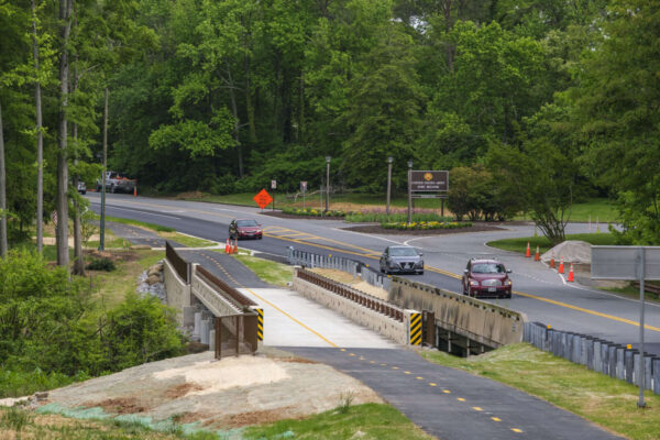
Fairfax County leaders will hold a ribbon-cutting ceremony and an inaugural bicycle ride and walk tomorrow (Friday) to celebrate the completion of the Mount Vernon Memorial Highway Trail.
Mount Vernon District Supervisor Dan Storck will join the Fairfax County Department of Transportation and the Department of Public Works and Environmental Services at George Washington’s Gristmill to mark the finishing of the trail.
The purpose of the project was to complete missing trail segments between Richmond Highway (Route 1) and Southwood Drive, a span of approximately two miles.
The project completes the missing links for the:
- East Coast Greenway Trail
- Potomac Heritage National Scenic Trail
- NoVa Loop Trail
Storck told FFXnow he has been pushing to get the project completed to connect more of the county’s Potomac Banks tourism sites and to provide new transportation and recreation options for residents.
“This new shared-use path now provides a continuous pedestrian and bicycle way from Richmond Highway to George Washington’s Mount Vernon Estate, then north to the City of Alexandria and the District of Columbia,” Storck said. “It will also provide connections to the future ‘The One’ Bus Rapid Transit System.”
The project constructed a 6,400-foot-long, 10-foot-wide shared-use path, which includes a pedestrian bridge adjacent to the Mount Vernon Memorial Highway bridge crossing Dogue Creek.
“The Potomac Heritage National Scenic Trail will provide a continuous facility for pedestrians and cyclists along Mount Vernon Memorial Highway from Route 1 to the Mount Vernon Estates,” the county website states.
The project also provided marked crosswalks and curb ramps compliant with Americans with Disabilities Act (ADA) regulations and standards to improve pedestrian crossings.
The county incorporated comments from a 2018 pedestrian safety public information meeting into the design plans.
“As an avid runner and cyclist, one of my priorities as supervisor has been pedestrian and bicycle safety, and completing missing trail and sidewalk connections,” Storck said.
The locally funded project cost approximately $6.5 million. The ceremony will start at 10 a.m.

Some Restonians are calling on Fairfax County to invest more funds into transportation safety upgrades in local schools, particularly within the South Lakes pyramid.
In a March 30 memo to the Fairfax County Planning Commission and Board of Supervisors, Hunter Mill District School Board Representative Melanie Meren flagged specific, problematic areas that may need more crossing guards, signage or physical upgrades and a comprehensive evaluation of crossings and bus stops.
“The safety of our students and community members is paramount and as you know all-too-well throughout Fairfax, residents have experienced transit-related deaths, incidents and close-calls,” reads the memo, which was first reported by WTOP.
Their hope is that concerns and considerations will be incorporated or inform the ongoing update to Reston’s comprehensive plan. A document resulting from over-two-year-long effort is expected to go before the Board of Supervisors later this year.
Tentatively, a staff report on the draft comprehensive plan created by a task force assembled by Hunter Mill District Walter Alcorn is expected sometime this month.
In a statement to FFXnow, Board of Supervisors Chairman Jeff McKay emphasized that bicyclist and pedestrian safety is a top priority of the county.
The Board of Supervisors takes the issue of traffic safety seriously, especially pedestrian and bicycle safety. Which is why we have committed $100 million for infrastructure improvements, $25 million of which has already been allocated. We have launched a speed camera pilot program that in 30 days issued over 1400 warnings to drivers and is expected to issue many more once all potential violations are processed. We are exploring our options with red light cameras and other types of photo enforcement as well.
Reston Association’s Multimodal Transportation Advisory Committee (MTAC) has scheduled a virtual town hall for 6:30 p.m. tomorrow (Thursday) to discuss pedestrian safety near Reston schools.
“As Reston’s citizen advisory committee on various forms of transportation modes throughout the community, MTAC would like to hear from members on their experiences, concerns and suggestions about transportation in Reston,” RA said in a newsletter last Friday (May 5).
A breakdown of the concerns raised by Meren is below: Read More
A major project to improve the accessibility of Van Buren Street in Herndon is officially complete.
Known as a “complete streets project” in transportation jargon, the project widened Van Buren Street along a one-half mile stretch from Old Spring Street to Herndon Parkway.
Complete streets is an approach to designing streets that supports safety and access for all users, including pedestrians and bicyclists.
In addition to widening travel lanes to 11 feet, the project added curb-and-gutter and bicycle lanes in each direction. Other upgrades include the addition of 5-foot-wide sidewalks, crosswalks, and traffic signals at Alabama Drive. Overhead utility poles were also relocated and stormwater management facilities upgraded.
Construction on the project started in the spring of 2022.
At a Herndon Town Council meeting late last month, Town Manager Bill Ashton II said the project was substantially complete.
“We have had the contractors out there making some corrections to some elements that we found were deficient to the design,” Ashton said.
He also noted that the project has been in the works for years.
“This is a project that has probably been ten years plus in the making,” he said.
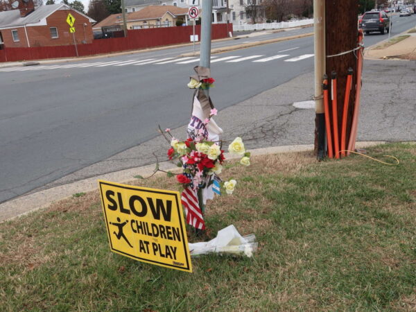
To the relief of Bailey’s Crossroads residents, some traffic safety improvements are in the works for the often harrowing area where Columbia Pike and Route 7 (Leesburg Pike) meet.
Perhaps the most urgent change will be the addition of a pedestrian hybrid beacon at the crosswalk across Columbia Pike at Tyler Street — the intersection where a driver hit and killed Justice High School student Lesly Diaz-Bonilla in November.
The Fairfax County Board of Supervisors approved an allocation of $920,000 to fund improvements at the intersection on April 11 as part of a $25 million slate of pedestrian safety projects planned throughout the county.
In the wake of Diaz-Bonilla’s death, over 1,000 residents signed an in-person and online petition calling for a reduction of the speed limit on Columbia Pike from 35 to 25 mph and other changes to the intersection, according to the Bailey’s Crossroads & Culmore Place-Based Initiative (PBI) Coalition, a community initiative led by George Mason University.
“This is a daily route to school for many children, including my own, and a route to work for many of us in Culmore,” resident Laura Doughty said in a press release from the coalition. “The lack of safety features for pedestrians coupled with the high-speed traffic makes it extremely dangerous for those of us who walk in the community everyday.”
Just 17 years old, Diaz-Bonilla had dropped off a younger sibling at a bus stop in front of the Barcroft View Apartments when a sedan crashed into her shortly before 9 a.m. on Nov. 16. After the crash, community members said they’d raised concerns about the intersection’s safety for years.
A report released last summer found that high vehicle speeds, incomplete sidewalks and limited crossings make Bailey’s Crossroads dangerous for pedestrians, particularly along the major corridors of Columbia Pike and Route 7.
A pedestrian hybrid beacon requires vehicles to stop if a pedestrian is present and pushes an activation button. A rapid flashing beacon with a pedestrian refuge island could be considered at the Tyler Street crosswalk instead if a hybrid beacon “is not feasible or warranted,” county staff said in a list of the safety projects that the board approved.
The April 11 vote also designated $1.9 million for a sidewalk on westbound Route 7 in front of the Liberty Gas station at 5930 Leesburg Pike in Culmore. A pedestrian was killed there in December 2021.
By press time, the Fairfax County Department of Transportation hadn’t returned a request for comment on when the projects will be implemented.
So far, the county has allocated about $30 million out of the $100 million that the Board of Supervisors pledged to spend on active transportation safety projects over six years, starting in 2022.
The inclusion of the Bailey’s Crossroads improvements in the latest package is the result of advocacy by residents, businesses, nonprofits and other organizations that have united around the need for safer streets, PBI Coalition program manager and Fairfax Families for Safe Streets Board of Directors member Katie Wilson said.
“The PBI Coalition will continue building these pipelines between local residents, organizations, and county leadership to amplify resident voices and ultimately work in partnership to build a community where all thrive,” Wilson said.
In a separate project, the county is planning to build a sidewalk and make other improvements in the Annandale section of Columbia Pike.
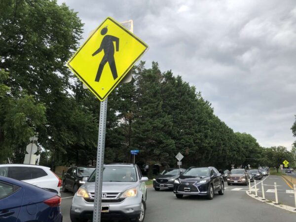
Fairfax County could be taking some notes from New York City and Portland as it tries to turn back the surge of recent pedestrian fatalities.
The Board of Supervisors directed the Fairfax County Department of Transportation on Tuesday (March 21) to review turn-calming measures from other jurisdictions, discuss options with the Virginia Department of Transportation, and come back to the board’s transportation committee with an analysis of how that can be implemented.
“Over the past several years, this Board has taken significant steps to prioritize pedestrian safety,” Board of Supervisors Chairman Jeff McKay said. “Despite these efforts, there were still sadly 32 pedestrian fatalities in Fairfax County on our roads in 2022, the highest number since consistent statistics started being collected in 2010.”
As FFXnow reported last week, FCDOT’s Trails, Sidewalks and Bikeways committee (TSB) delved into the issue and asked the Board of Supervisors to prioritize additional safety measures along major arterial roadways throughout Fairfax County.
“The first is a turn calming, like in New York, San Francisco and Portland,” McKay said. “These programs can reduce turning speeds and thus pedestrian fatalities.”
Left-turn calming aims to reduce turning speeds, eliminate sharp turns, and create “hardened centerlines” that use rubber speed bumps to slow drivers.
McKay said county staff’s report on turn-calming should also include an estimate of the cost.
The second item is a request that no crosswalk at the site of a pedestrian fatality be eliminated unless there is a compelling reason to do so.
The question of eliminating crosswalks took some board members by surprise until Braddock District Supervisor James Walkinshaw explained that the TSB letter references the planned elimination of a crosswalk at Braddock Road and Kings Park Drive in West Springfield.
Walkinshaw explained VDOT intends to move the sidewalk to a safer location.
“The plan is to eliminate that entire signalized intersection and move the crosswalk to a different and safer location, where it’s separated from the turns from Kings Park Drive onto Braddock Road,” he said.
Hunter Mill Supervisor Walter Alcorn noted that, in addition to turn-calming and prioritizing crosswalks, the county also has an ongoing speed camera pilot program.
“I would also note that we are doing our speed camera pilot, which is also getting underway,” Alcorn said. “It underscores that this is really a tough problem…We need to look and see what else can we do to make our streets safer.”

(Updated at 1:30 p.m. on 3/20/2023) Fairfax County is in the midst of deciding where nearly $25 million in funding for pedestrian and bicyclists improvements will be allocated.
After combing through more than 2,000 possible projects, staff have develop a draft list of prioritized projects, according to Michael Guarino, head of the Fairfax County Department of Transportation’s capital projects division.
At a Board of Supervisors transportation committee meeting on Tuesday (March 14), Guarino said the county is using spatial analysis tools to help sift through roughly 2,800 unfunded projects and project requests. The list was then further pared down by examining network connectivity and trip generators.
“We’re using technology as best as we can. I think are areas where we can do it more. Overall, the process is working the way we want it to, it’s just taking longer than we want it to,” Guarino said.
The decision is part of the county’s $100 million commitment to support active or non-motorized transportation access and safety improvements.
The first $5 million in funding, approved in November 2022, included $2 million for trail maintenance, $2.7 million for crosswalk projects, and $200,000 for a safe routes project near Bush Hill Elementary School. An additional $100,000 was allocated to speed feedback signs for the Fairfax County Police Department.
As part of the next cycle, $2.3 million for crosswalk projects has already been approved, along with $400,000 to repair and replace existing rapid flashing beacons through fiscal year 2028.
Board members lauded staff for the methodology used to create the draft list.
“It was very well done the way you pulled this all together,” Dranesville District Supervisor John Foust said.
The county plans to seek additional money for pedestrian intersection improvements at Blake Lane and Bushman Drive in Oakton as well as Beverly Road at Old Dominion Drive and Elm Street at Old Dominion Drive in McLean after missing out on a federal grant.
The county did not receive the Safe Streets and Roads for All grant due to a lack of needed data to back up claims for the need for the projects, along with the projects not being ready to build yet, Guarino said.
Mason District Supervisor Penny Gross noted that some projects can take years to come to fruition. She said it took nearly 37 years to install sidewalks on Sleepy Hollow Road — a project that is currently under construction.
“It wasn’t all the county’s fault,” Gross said, adding that an iterative process will ensure that projects are shovel-ready.
The proposed list of active transportation projects includes: Read More

