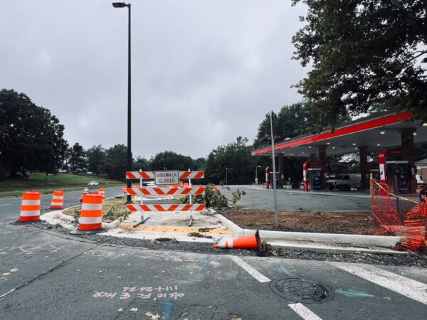
The Virginia Department of Transportation (VDOT) is asking for public input on how to reduce congestion and the number of crashes on two half-mile sections of road in Springfield.
A new survey is open through June 15, asking residents about their traveling habits and safety concerns along Franconia Road between Backlick Road and Loisdale Road. The survey also focuses on Commerce Street between Amherst Avenue and Franconia Road.
The survey marks the beginning of a STARS (Strategically Targeted Affordable Roadway Solutions) study that will help develop “proposed improvements that localities can pursue for funding,” a press release says.
Those two sections of roads, particularly Franconia Road, are of concern because they often have traffic congestion due to the nearby I-95 interchange. There’s also a high number of crashes, according to VDOT.
That half-mile section of Franconia Road averages about 69,000 vehicles a day and has had 162 crashes between January 2015 and October 2022, per a VDOT presentation. That includes at least one fatal crash and several that resulted in severe injuries.
The portion of Commerce Street in the study has much less volume, with only about 19,000 vehicles every day. But there have been even more crashes along the road during that same time period.
A large number of the 171 crashes have resulted in property damage only, but several did lead to severe injury.
VDOT is looking into a number of improvements along those roads focused on safety, the presentation notes.
That includes “innovative intersections” that have different shapes or traffic flow patterns. It could also mean adding Rectangular Rapid Flashing Beacons, high-visibility crosswalks and improved bicycle facilities, including better bicycle lane transitions and pavement markings.
What exactly will be done will, at least partially, depend on the results of the public survey, VDOT said.
In the questionnaire, respondents are asked to rank their top concerns, with traffic congestion, pedestrian safety, public transit access, and speeding among the options listed. They are also asked when they typically traveled along those roads, by what method of transportation, and when they typically experience congestion.
The survey “will be used to help develop potential safety and operational alternatives that will be evaluated and presented during the second round of public involvement scheduled for this winter,” the project website reads.
The study is set to be completed in spring 2024. No construction timeline has been set as of yet, per the press release.

The Town of Vienna Police Department will once again usher in summer with a hardline approach to stop sign violations.
The department launched a campaign today (Thursday) that will see officers step up their enforcement of traffic safety laws, especially those governing stop signs, after seeing “a noticeable increase in such violations.”
“For the entire month of June, we have taken the initiative to address the repeated violations that have been reported by both residents and Town of Vienna staff members,” VPD Public Information Officer Juan Vasquez said.
Like in a similar campaign organized last June, the crackdown will involve a particular focus on drivers who roll through or ignore stop signs:
Officers will be actively present to issue tickets and remind drivers about the importance of coming to a complete stop when approaching a stop sign. Whether facing a solid or flashing red light, drivers must stop before entering the crosswalk, intersection, or stop line. It’s worth noting that, under certain circumstances, a stop sign violation can be cited as reckless driving.
Motorists who receive a ticket for a stop sign or red light violation will face a fine and three demerit points on their driving record. The Vienna Police Department emphasizes the need for defensive driving, courteous behavior, and strict adherence to all traffic laws to ensure safe arrival at destinations.
Virginia law defines reckless driving as anyone who drives a vehicle “in a manner so as to endanger the life, limb, or property of any person,” which can include a failure to yield the right-of-way.
Reckless driving is classified as a Class 1 misdemeanor, which carries maximum punishments of one year in jail and a $2,500 fine. It can be elevated to a Class 6 felony if the driver doesn’t have a valid license and the incident resulted in another person’s death.

The City of Fairfax is asking the public for help in planning long-anticipated improvements to Jermantown Road.
On Wednesday (May 31) from 7-9 p.m., Fairfax will hold an open house at Katherine Johnson Middle School (3801 Jermantown Road) so the public can weigh in on preliminary design concepts for the Jermantown Road Corridor Improvement Project.
The project is set to add sidewalks, medians, and pedestrian crossings along about a mile-long section of two-lane Jermantown Road that extends from Route 50 to the city limits at the I-66 interchange. Other changes include a traffic circle at Orchard Street as well as a right-turn lane south of Orchard Street.
Also proposed are enhanced roadway crossings at Katherine Johnson Middle School and Providence Elementary School (3616 Jermantown Road), and a reduction of the number of driveways and access points along the road.
“Jermantown Road provides key local access (residential, school, & commercial locations) and connections to Fairfax County,” the project page says. “Current conditions are challenging for some users, and accommodating future growth and changes will require improvements to help the city.”
Fairfax City received $21 million from the Northern Virginia Transportation Authority to make these road improvements. There’s no timeline for when construction might begin or be completed, with the project now in the design phase.
The city first brought on engineers to provide a concept plan for the project in 2018. Two options were put on the table: a widening of all of Jermantown Road from two to four lanes or more limited “spot improvement” option. The latter prevailed.
Earlier this month, city council members got a preview of the planned improvements during a work session with city staff, including transportation director Wendy Block Sanford.
According to staff, the average daily traffic along Jermantown Road is about 14,000 vehicles a day — a relatively high number for a road of this nature. There are also more than 30 access points to the road, like entrances or driveways. Typically, access points are where more crashes occur.
The road also is home to a growing population, making pedestrian and bicycle access even more crucial. About 1,100 households either live on or within a quarter-mile of the road, per the staff presentation. In addition, about a quarter of the roughly 2,000 students who attend the two schools could walk to school if safety was improved.
As noted at the council work session, tomorrow’s open house is really the beginning of the engagement process.
“The 31st is really meant to be a kick-off and listening session,” Sanford told the city council. “We don’t have the answers yet. What we know are what some of the challenges are and we want to know more about those challenges and understand everything. There will be plenty more. This is truly the first engagement of many engagements.”
While not part of the project, but related since it connects, the Jermantown Road Bridge over I-66 is now scheduled to likely open in the fall. Previously expected to reopen this spring, the bridge is getting new sidewalks and bicycle paths.
Sanford said there are “some issues” going on between the Virginia Department of Transportation and the contractor, but the expectation is that it will open later this year.
Image via Google Maps

Fairfax County is looking into adjusting its signage rules to allow for brighter and bigger electronic signs.
Casey Judge with the county’s Zoning Administration Division presented the proposed changes during a Board of Supervisors land use policy committee meeting on May 16.
The changes include increasing the maximum brightness for nonresidential districts to 300 nits (a unit that measures the brightness a sign is emitting) at sunset. Current regulations require electronic signs to automatically dim to 40-100 nits at sunset.
The changes also includes requiring sign permit applicants to submit sign specifications.
In addition, the three existing application processes that the county currently has for nonresidential areas could be consolidated into one process.
“This does mean that all sign applications would go to the board for approval rather than the current [comprehensive sign plans],” which only need to be approved by the Fairfax County Planning Commission, Judge said.
Proposed modifications for electronic display signs with special exceptions include increasing the number, height, and size of freestanding signs, allowing building-mounted electronic display signs, and increasing the brightness to 600 nits.
Last May, while discussing the matter, county staff told the committee that the existing rules are old and that businesses wanted to be more competitive. Judge also suggested that easing the application process could be helpful to businesses.
Hunter Mill District Supervisor Walter Alcorn, the committee’s vice chair, questioned how the county is handling the convergence of “what’s a sign and what’s a display.”
“These things that we have traditionally dealt with as signs are being used in other means, or for other purposes,” Alcorn said.
Judge said a standard has been added that focuses on traffic safety and overall placemaking effects as part of the electronic display signs.
“I do hope that that standard can help guide our staff when they’re making that analysis to ensure that we’re looking at size and location, more so than the content in making our recommendations,” Judge said.
Braddock District Supervisor James Walkinshaw questioned the proposed increase from 100 to 300 nits, which he called pretty significant.
“That’s really in response to research looking at other jurisdictions that have much higher nit level limitations and it allows for those higher definition screens that we’re seeing,” Judge answered.
Judge said the county is seeking authorization and public hearings later this year.

The speed limit on Richmond Highway (Route 1) has been permanently lowered through much of Fairfax County.
Starting next Tuesday (May 23), the legal limit will be reduced from 45 to 35 mph along a roughly 7-mile stretch between the Alexandria City limits at the Capital Beltway (I-495) and Jeff Todd Way/Mount Vernon Memorial Highway, the Virginia and Fairfax County transportation departments announced yesterday (Monday).
The departments said the change is designed “to optimize safety and operations for pedestrians, bicyclists, drivers and transit users” along a corridor that routinely sees devastating crashes.
Just this year, there have been at least 102 vehicle crashes on the Fairfax County section of Richmond Highway, injuring 75 people, according to state data. Prior to 2018, the total number of crashes consistently topped 400, peaking at 508 crashes in 2012.
So far in 2023, three people have been killed on the roadway: two pedestrians and a motorcyclist. Since 2011, there have been about 37 fatalities.
The Virginia Department of Transportation recommended in July 2022 that the speed limit be lowered after a year-long speed study found crashes occur more frequently on Richmond Highway than other primary highways in Northern Virginia, on average.
“The team also found that Richmond Highway between Buckman Road/Mount Vernon Highway and the Alexandria southern city limits had a higher incidence of pedestrian [and] bicycle crashes and speed-related crashes compared to other sections of Richmond Highway,” VDOT said.
However, the study recommended maintaining the existing 45-mph speed limit in the Fort Belvoir area from Belvoir Road to Jeff Todd Way. That 0.75-mile stretch had a lower crash rate, though about 50% of vehicles still exceed the speed limit, according to VDOT.
At a public meeting last summer, some community members raised concerns about the lower speed limit increasing congestion and questioned how effectively it’ll be enforced, but VDOT officials said the study indicated the change will have a “minimal” impact on traffic and allow tougher penalties on drivers who violate the limit.
Even a small decrease in vehicle speeds can lead to fewer serious crashes, according to the National Highway Traffic Safety Administration. A 5-mph reduction from 40 mph, for example, will produce an estimated 34% reduction in crashes with injuries.
Signs showing the new speed limit will be placed along Richmond Highway on May 23, VDOT said. A final report on the speed study is expected to be finished around the middle of this year.

Some Restonians are calling on Fairfax County to invest more funds into transportation safety upgrades in local schools, particularly within the South Lakes pyramid.
In a March 30 memo to the Fairfax County Planning Commission and Board of Supervisors, Hunter Mill District School Board Representative Melanie Meren flagged specific, problematic areas that may need more crossing guards, signage or physical upgrades and a comprehensive evaluation of crossings and bus stops.
“The safety of our students and community members is paramount and as you know all-too-well throughout Fairfax, residents have experienced transit-related deaths, incidents and close-calls,” reads the memo, which was first reported by WTOP.
Their hope is that concerns and considerations will be incorporated or inform the ongoing update to Reston’s comprehensive plan. A document resulting from over-two-year-long effort is expected to go before the Board of Supervisors later this year.
Tentatively, a staff report on the draft comprehensive plan created by a task force assembled by Hunter Mill District Walter Alcorn is expected sometime this month.
In a statement to FFXnow, Board of Supervisors Chairman Jeff McKay emphasized that bicyclist and pedestrian safety is a top priority of the county.
The Board of Supervisors takes the issue of traffic safety seriously, especially pedestrian and bicycle safety. Which is why we have committed $100 million for infrastructure improvements, $25 million of which has already been allocated. We have launched a speed camera pilot program that in 30 days issued over 1400 warnings to drivers and is expected to issue many more once all potential violations are processed. We are exploring our options with red light cameras and other types of photo enforcement as well.
Reston Association’s Multimodal Transportation Advisory Committee (MTAC) has scheduled a virtual town hall for 6:30 p.m. tomorrow (Thursday) to discuss pedestrian safety near Reston schools.
“As Reston’s citizen advisory committee on various forms of transportation modes throughout the community, MTAC would like to hear from members on their experiences, concerns and suggestions about transportation in Reston,” RA said in a newsletter last Friday (May 5).
A breakdown of the concerns raised by Meren is below: Read More

To the relief of Bailey’s Crossroads residents, some traffic safety improvements are in the works for the often harrowing area where Columbia Pike and Route 7 (Leesburg Pike) meet.
Perhaps the most urgent change will be the addition of a pedestrian hybrid beacon at the crosswalk across Columbia Pike at Tyler Street — the intersection where a driver hit and killed Justice High School student Lesly Diaz-Bonilla in November.
The Fairfax County Board of Supervisors approved an allocation of $920,000 to fund improvements at the intersection on April 11 as part of a $25 million slate of pedestrian safety projects planned throughout the county.
In the wake of Diaz-Bonilla’s death, over 1,000 residents signed an in-person and online petition calling for a reduction of the speed limit on Columbia Pike from 35 to 25 mph and other changes to the intersection, according to the Bailey’s Crossroads & Culmore Place-Based Initiative (PBI) Coalition, a community initiative led by George Mason University.
“This is a daily route to school for many children, including my own, and a route to work for many of us in Culmore,” resident Laura Doughty said in a press release from the coalition. “The lack of safety features for pedestrians coupled with the high-speed traffic makes it extremely dangerous for those of us who walk in the community everyday.”
Just 17 years old, Diaz-Bonilla had dropped off a younger sibling at a bus stop in front of the Barcroft View Apartments when a sedan crashed into her shortly before 9 a.m. on Nov. 16. After the crash, community members said they’d raised concerns about the intersection’s safety for years.
A report released last summer found that high vehicle speeds, incomplete sidewalks and limited crossings make Bailey’s Crossroads dangerous for pedestrians, particularly along the major corridors of Columbia Pike and Route 7.
A pedestrian hybrid beacon requires vehicles to stop if a pedestrian is present and pushes an activation button. A rapid flashing beacon with a pedestrian refuge island could be considered at the Tyler Street crosswalk instead if a hybrid beacon “is not feasible or warranted,” county staff said in a list of the safety projects that the board approved.
The April 11 vote also designated $1.9 million for a sidewalk on westbound Route 7 in front of the Liberty Gas station at 5930 Leesburg Pike in Culmore. A pedestrian was killed there in December 2021.
By press time, the Fairfax County Department of Transportation hadn’t returned a request for comment on when the projects will be implemented.
So far, the county has allocated about $30 million out of the $100 million that the Board of Supervisors pledged to spend on active transportation safety projects over six years, starting in 2022.
The inclusion of the Bailey’s Crossroads improvements in the latest package is the result of advocacy by residents, businesses, nonprofits and other organizations that have united around the need for safer streets, PBI Coalition program manager and Fairfax Families for Safe Streets Board of Directors member Katie Wilson said.
“The PBI Coalition will continue building these pipelines between local residents, organizations, and county leadership to amplify resident voices and ultimately work in partnership to build a community where all thrive,” Wilson said.
In a separate project, the county is planning to build a sidewalk and make other improvements in the Annandale section of Columbia Pike.

The City of Fairfax is moving forward with a plan to make the Chain Bridge Road and Eaton Place intersection safer.
After some debate at an April 11 meeting — and an alternate motion was proposed and failed — the Fairfax City Council ultimately voted 4-2 in favor of a redesign to the intersection, which is just outside Oakton near the Fairfax County border.
Changes planned for the intersection include a new sidewalk on the west side of the road, a new traffic signal, and more.
“Improving this intersection, which serves as the northern gateway to the city and connects travelers to the Northfax area, is a top priority for the city,” the city said in a release.
The City of Fairfax received $10.7 million in funding from the Northern Virginia Transportation Authority (NVTA) to evaluate the project and confirm the congestion reduction benefits.
According to the city, the redesign will include:
- Converting the west side service road to one-way inbound from Chain Bridge Road
- Constructing a new exit for Cobbdale vehicular traffic via a new traffic signal (being installed by VDOT) north of Eaton Place
- Constructing a residential sidewalk on the west side of the western service road to enable consolidation of the school bus stops
- Constructing a separate shared use path on the west side service road between the new traffic signal and Eaton Place, to extend the shared use path being installed by VDOT north of the new signal
- Implementing a buffer management plan on the west side buffer to remove dead trees, remove vines from healthy trees, and add supplemental vegetation
- Closing the service road access points from Eaton Place on the east side of the intersection
- Converting the single left southbound left turn lane from Chain Bridge Road to Eaton Place to two lanes controlled by a restricted green arrow (versus allowing lefts on green)
At the city council meeting, Councilmember So Lim said she was torn between the original plan and alternatives suggested by staff.
The proposed design would separate the shared-use path and sidewalk, while staff’s alternative combined the two elements.
Ultimately, Lin said the city had to go with the most safety precautions possible for a project like this.
“I was really torn between alternate plan number one or the recommended plan, but I think the safety of the bikers and pedestrians has to be a priority,” Lim said. “Right now, there may not be many bikers or pedestrians, but once we create a shared use path, that will be here to stay. I have to make a decision, not just about today, but how it’s going to be five or ten years from now. I’m going to support the original plan.”
According to Fairfax City, Chain Bridge Road sees approximately 39,000 vehicles per day, and the Eaton Place intersection “experiences significant congestion and safety concerns.”
“The intersection is a critical component of the regional transportation network, with access ramps to I-66 located just north of the intersection,” the city said in its news release. “The intersection has been the site of many traffic accidents, including fatalities.”
Construction on the improvements isn’t expected to start for another two years, the city says.

It’s repaving and restriping season once again, with public meetings coming later this month on proposed projects that would add bicycle lanes and improve crosswalks.
April marks the beginning of an annual process that ends in November with hundreds of miles of roadway being repaved and restriped by the Virginia Department of Transportation (VDOT).
In Fairfax County, more than 1,700 miles of roadway are expected to be repaved this year. The work often leads to new bike lanes, shoulders, crosswalks, signage, and street markings.
The program is “an opportunity to increase driver, bicyclist and pedestrian safety with road and crosswalk improvements while minimizing the financial investment in restriping work,” the Fairfax County Department of Transportation says on its website.
The first virtual public meeting hosted by VDOT and FCDOT will come on April 17 at 7 p.m. and cover proposals in the Hunter Mill and Providence districts.
One plan would add bicycle lanes on Glade Drive between Sunrise Valley Drive and Reston Parkway in Reston by narrowing the driver travel lanes.
In addition, upgrades are proposed at Monroe Street and Monroe Manor Drive in Herndon. This could include “marked crosswalks, high-visibility crosswalks and/or crosswalk signage,” the county says.
After a proposal for Ellenwood Drive was discussed at a separate meeting in February, the Providence District could get more bicycle lanes at four spots in the Merrifield and Annandale area:
- Executive Park Avenue between the Red Cross building and Prosperity Avenue
- Gatehouse Road between Telestar Court to Gallows Road and, potentially, Gallows Road to Williams Drive
- Williams Drive between Eskridge Road and Arlington Blvd and potentially between Arlington Blvd and Pennell Street
- Willow Oaks Corporate Drive between Williams Drive and Gallows Road
The lanes would be added by narrowing travel lanes or “repurposing underutilized parking lanes.”
Upgrades are also being considered for the intersection of Willow Oaks Corporate Drive and Professional Center Access Road in Merrifield. This could include marked crosswalks, high-visibility crosswalks, and additional signage.
Comments on projects in both districts will be accepted through the close of business on May 1.
Virtual public meetings will be held to discuss projects in Sully District on April 18, Franconia and Mount Vernon on April 19, Braddock and Mason on April 20, and Springfield on April 26.
Most of the proposed projects in those districts would also add bike lanes and improve crosswalks.
While all repaving and restriping work is set to begin soon and conclude by November, exact work dates for each project will be available “approximately ten days prior to work beginning.”
If the repaving requires parking to be limited, signs will be posted at least three business days in advance. Parked cars, basketball hoops, and garbage cans may need to be moved to accommodate the work.
In general, work hours will be limited to “outside of rush hours” with crews typically on-site in neighborhood streets on weekdays between 9 a.m. to 3 p.m. However, on interstates and some primary roads, work might happen overnight to limit the impact.
Residents should expect construction vehicles in their neighborhood during the project, and the county is asking motorists to “be alert to temporary traffic patterns.”

(Updated at 5:40 p.m.) Fairfax County transportation planners are considering the possibility of adding a traffic beacon to the intersection of Sunrise Valley Drive and the Washington & Old Dominion Trail (W&OD) near Robert Fulton Drive in Reston.
(Correction: This story previously said the beacon is being considered for the intersection of Sunrise Valley Drive and Wiehle Avenue.)
Robin Geiger, a spokesperson for the Fairfax County Department of Transportation (FCDOT) , said that the project is in the early phases of planning.
“There is no specific timeline but the team is continuing to prioritize projects over the new few months to be included in the remaining $70 million the Board of Supervisors approved for active transportation projects,” Geiger said.
The board has committed to spending $100 million on projects that improve road safety or accessibility for pedestrians, bicyclists and other non-motorized travelers.
One of thousands of projects that are being considered by the county, the Sunrise Valley and W&OD project could be considered for funding this fall. FCDOT is considering adding beacons to the area because of the “historically elevated rate of bike crashes, likely because the W&OD trail is a popular bicycle route,” Geiger said.
Changes would also need to be coordinated with NOVA Parks and the Virginia Department of Transportation.
Geiger said it is unclear what kind of signal would be installed.
Because of the speed limit, traffic volumes and lane configuration of Sunrise Valley Drive and the regional trail, a rectangular rapid-flashing beacon is not recommended based on state guidelines and national best practice, according to FCDOT.
County planners advise that a pedestrian hybrid beacon may be more appropriate, but more traffic analyses are required because of an adjacent signal at Robert Fulton Drive.
Last month, the county narrowed its list for $25 million of the pledged active transportation project funding. Planners combed through more than 2,000 possible projects to develop a draft list of priorities that’s set to be approved by the Board of Supervisors today (Tuesday).
Construction is currently underway on a pedestrian bridge for the W&OD Trail over Wiehle Avenue.
Photo via Google Maps