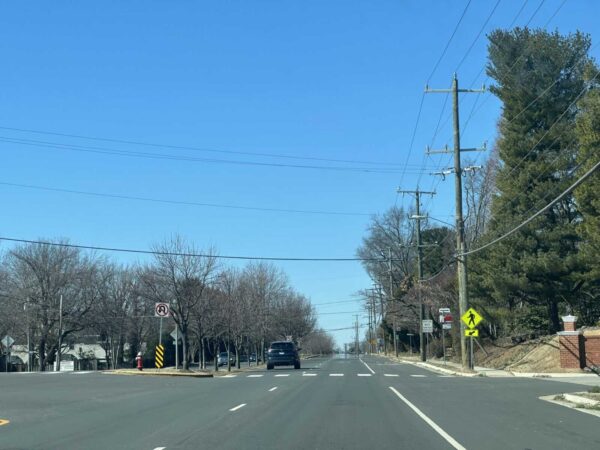
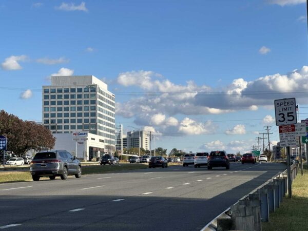
Fairfax City will complete the George Snyder Trail as planned after all.
In response to some community concerns, the Fairfax City Council discussed changing the pedestrian and bicycle project’s scope or even canceling it altogether during its meeting on Tuesday (Jan. 23). But council members failed to agree on any of the proposed alternatives, allowing the city to stay the course by default.
“None of the resolutions received enough support to change the current trail alignment,” City of Fairfax spokesperson Matthew Kaiser confirmed to FFXnow. “Staff will continue to acquire the needed land and come back to council in six months or so for [a construction] bid approval.”
The city has acquired rights-of-way for two of five needed parcels, Fairfax City Transportation Director Wendy Sanford told the council.
Over a decade in the making, the planned trail will run along the south side of Accotink Creek for about 1.8 miles from Chain Bridge Road (Route 123) to Fairfax Blvd (Route 50), connecting the existing George Snyder Trail to the I-66 shared-use path that’s slated to finish this spring.
However, some residents and environmental groups, including the Audubon Society of Northern Virginia, have objected to the proposed route for the 10-foot-wide trail, which will wind through a wooded area and require removing 553 trees. A segment in Shiloh Street Park that would’ve eliminated another 11 trees has been dropped from the plan, according to a city staff report.
The city has said 858 trees and 815 shrubs, all native species, will be planted to offset the lost trees.
Though the design is complete, Sanford said the council could cancel the project, realign the trail east of Fair Woods Parkway to use existing roads more, or construct only the segment west of Fair Woods Parkway.
Staff recommended either sticking with the existing plan or building only the western segment. If it cancels the project, the city would have to repay at least $395,000 in federal funding out of the $3 million it has spent so far, potentially putting it at a disadvantage for receiving future awards, Sanford said.
Most of the project’s $17.6 million budget comes from a concession fee that the I-66 Outside the Beltway toll lanes operator agreed to provide for transportation improvements in the corridor. Sanford said it’s unclear if any of that will need to be returned.
Revising the trail’s eastern segments would require restarting the design and engineering process, according to Sanford.
“This would delay the project, cause additional costs in engineering and potentially higher construction costs due to inflation when we do get to construction,” she told the council. “There’s also no assurance of feasibility for the new alignment or public support for any of the alternatives.”
Councilmember Jeffrey Greenfield proposed building the western portion with two tweaks: merging it with the sidewalk on Route 50 where they run parallel and possibly rerouting it through WillowWood Plaza, an office complex on Eaton Place under review for redevelopment as housing. Read More
Missing pedestrian links along Sunrise Valley Drive in Reston may soon be filled following the acquisition of land.
The Fairfax County Board of Supervisors formally accepted land at 11810 Sunrise Valley Drive from developer JBG Smith, which owns the Sheraton hotel there.
The acquisition will allow the county to complete a 10-foot-wide walkway from Reston Parkway to Soapstone Drive.
The gift comes after JBG Smith — which owns one of the parcels affected by the walkway — declined to grant limited land rights to construct the project. The company instead asked the county to take ownership of the parcel in its entirety, according to a board matter introduced by Hunter Mill District Supervisor Walter Alcorn on yesterday (Tuesday).
“Acceptance of this small parcel would allow the county to avoid condemnation to complete the Sunrise Valley Drive pedestrian enhancements and would provide the county with land to make one or more small improvements on this open space in the future,” Alcorn wrote in the board matter.
County staff have previously said construction is expected to begin this winter on the project, which will improve existing walkways and install missing links along 1,500 linear feet on the north side of Sunrise Valley Drive.
According to the the board’s transportation priorities plan, roughly $8.8 million has been recommended over six years to install separated bicycle lanes and pedestrian facilities on the north side of Sunrise Valley Drive.
Image via Google Maps
Town of Herndon officials are seeking $1.5 million in federal funds for major improvements along Sterling Road.
At a Herndon Town Council work session on Dec. 5, town staff noted that no local match is required to proceed with the project. The town is also requesting $500,000 for ADA-compliant sidewalk and trails improvements throughout Herndon.
Jaleh Moslehi, a project engineer for the Town of Herndon, said the Sterling Road project will include additional lane capacity improvements at the Herndon Parkway intersection, along with safety measures for pedestrians and bicyclists.
“The objectives for this project are to increase safety, to incorporate cycling and pedestrian improvements, reduce congestion, enhance connectivity and circulation, and also doing all of this, but retaining the residential character of the Sterling Road corridor,” she said.
Once completed, the project would reconfigure Sterling Road from Elden Street to Herndon Parkway in order to “reflect the town’s current plans for traffic management and circulation in residential areas,” according to the town’s budgetary documents.
The project will begin with a concept design and traffic impact analysis, determining whether there is a need for a signalized intersection at Crestview Drive. The study will also determine the feasibilty of a bicycle facility between Elden Street and the town limits.
In the second project, town-wide sidewalk and trail improvements are planned based on Herndon’s Pedestrian Plan and Bicycle Network Master Plan.
Funds for the Sterling Road project would come from a federal Regional Surface Transportation Planning program, while funding for the other improvements is through the Congestion Mitigation Air Quality program. Both projects are administered by Northern Virginia Transportation Authority (NVTA).
Councilmember Cesar del Aguila noted that he and others in the community were happy to hear that the Sterling Road project is moving forward.
Anne Curtis, a spokesperson for the Town of Herndon, said the Sterling Road project is on pause, initially as a result of “COVID delays but also due to need for additional funding.”
(Updated at 9:25 a.m. on 12/15/2023) The long-running effort to bring bus rapid transit (BRT) service to Route 7 is about to enter a new stage of planning, but for some Fairfax County leaders, the milestone doubles as a reminder of how much more still needs to be done to turn Northern Virginia’s vision into a reality.
The Fairfax County Board of Supervisors approved an agreement at its Dec. 5 meeting to help fund an engineering study and environmental analysis required to implement the bus system, which will serve the corridor from the Spring Hill Metro station in Tysons to the Mark Center in Alexandria.
Though they voted 9-1 in support of the agreement, some board members raised concerns about a lack of clarity on the project timeline from the Northern Virginia Transportation Commission, the regional organization that’s managing the planning process.
“I sit on NVTC, and I don’t have a comfort level yet that they have their hands wrapped around this,” Dranesville District Supervisor John Foust said. “Constantly, I’m asking for schedules — when is this going to happen? — and they never provide them.”
Foust — whose district includes the West Falls Church Metro area at the southern end of the BRT’s future Tysons segment — called NVTC a “great organization” and voted for the agreement, which was only opposed by Springfield District Supervisor Pat Herrity.
But Foust urged county and NVTC staff to provide a thorough breakdown of the long-range plan for the project known as Envision Route 7, including an estimate of when it would be completed “if everything goes as anticipated.”
“That would be very helpful, I think, in evaluating each step as we go forward,” he said.
Board of Supervisors Chairman Jeff McKay concurred, adding that the county doesn’t need specific dates but would find it “helpful” to get a more detailed timeline of key milestones to expect going forward.
He noted that NVTC has already been working on the dedicated Route 7 bus system for years, dating back to a transit study commissioned in 2013.
“The number one question I’ve had about this is, ‘What has been taking so long to get to this point and what does the future look like?'” McKay said. “What we do know is this will be a long-term project, but we need to have a reasonable understanding of what that means in terms of years.”
Fairfax County Department of Transportation acting director Gregg Steverson confirmed the request was “something we can provide to you.”
(Correction: This story initially misidentified Gregg Steverson as the NVTC acting director.) Read More
Any extension of the I-495 Express Lanes along the south side of the Capital Beltway should support additional transit options, Fairfax County leaders stressed in a recent letter to the Virginia Department of Transportation.
VDOT is currently studying options for completing the I-495 toll lanes by expanding them from the I-395/I-95 interchange in Springfield to Maryland Route 210 in Prince George’s County, an approximately 11-mile span that crosses the Woodrow Wilson Bridge in Alexandria.
At a meeting on Nov. 21, the Fairfax County Board of Supervisors approved a letter to Virginia Secretary of Transportation Sheppard Miller emphasizing the importance of accommodating transit in the project, which is intended to relieve congestion on what VDOT has said is the most heavily traveled segment of the Beltway.
“The County is appreciative that the Commonwealth is assessing solutions on the only interstate segment in Fairfax that does not have a transit benefit at this time,” the board’s letter said. “It is critical that additional travel choices are available in the Capital Beltway Corridor to move the most people as efficiently as possible in this region.”
VDOT staff presented several preliminary concepts at a public meeting on Sept. 12, including the addition of one or two general-purpose or express lanes in each direction or two reversible express lanes that would change direction with rush-hour traffic.
Staff said it has also explored adding a dedicated transit lane for buses and making adjustments that wouldn’t require new construction, such as supporting new bus routes or allowing the existing I-495 shoulders to be used as travel lanes during peak traffic periods. However, the congestion relief benefits would be limited without more space on the highway, according to the study team.
Taking a slightly more open stance than officials in Alexandria City, the Board of Supervisors didn’t comment on specific concepts, but it urged VDOT not to pursue any option that would rule out the possibility of future rail service over the Woodrow Wilson Bridge.
Opened to traffic in May 2008, the bridge was designed with a median to accommodate future transit, not with the expectation of toll lanes, Board of Supervisors Chairman Jeff McKay noted at the Nov. 21 meeting.
“From an equity standpoint, I do appreciate the fact that this is on the table, because this remains the only piece of interstate highway in Fairfax County that currently has no transit benefit whatsoever,” McKay said. “I acknowledge a failure of past efforts when projects were done to literally cut off this part of the county from the same types of transportation options that other parts of the county now have, including the communities that are sandwiched between the Springfield interchange project and the Woodrow Wilson project.”
According to the board’s letter, Fairfax County staff would support “an interim phase” without rail while Metro continues exploring how to increase capacity on its Blue, Orange and Silver lines, a study that has been underway since 2019 and could conclude by the end of this year. Read More
Construction on an overhaul of the Fairfax County Parkway and Popes Head Road interchange is slated to begin by the end of this year.
The Virginia Department of Transportation awarded a $49 million construction contract for the project in Fairfax Station last week to the Roanoke-based company Branch Civil, which is expected to begin on-site activities in December.
In the works since at least 2017, the project will replace the existing, four-way intersection controlled by a traffic signal with three roundabouts and two bridges over Fairfax County Parkway “that will allow traffic to flow freely,” VDOT said.
Other elements include:
- Building a short segment of the future Shirley Gate Road extension that will provide pedestrian and vehicle access to the future Patriot Park (Fairfax County is designing the rest of the Shirley Gate Road extension)
- Constructing a shared-use path linking the Fairfax County Parkway Trail to the future Patriot Park
- Reconstructing the Fairfax County Parkway Trail
- Installing a sidewalk along the north side of Popes Head Road
- Extending Ladues End Lane to the new roundabout at Popes Head Road
- Adding an acceleration lane for drivers turning from Nomes Court onto northbound Fairfax County Parkway
According to VDOT, Fairfax County Parkway carries an average of 64,000 vehicles a day, while Popes Head Road averages about 3,200 vehicles daily. The long wait at the traffic light — which state officials have said can last five minutes during peak travel times — has been a source of frustration for commuters.
The Fairfax County Board of Supervisors gave its support for the proposed redesign in May 2020. Springfield District Supervisor Pat Herrity said at the time that the project “will provide significant congestion relief and a safer route for thousands of residents,” according to The Connection.
VDOT is ultimately planning to widen Fairfax County Parkway from four to six lanes, starting with the northern section from Nomes Court to Route 29, though some have questioned the department’s use of road widenings as an answer to traffic congestion.
Earlier this year, the Fairfax County Department of Transportation revisited a 2021 study of the parkway and determined that it should be six lanes, rather than the eight that had previously been recommended. Staff also stressed the need for bicycle and pedestrian improvements, calling the completion of a trail from Reston to Fort Belvoir a top priority.
The Popes Head Road interchange also ties into plans to extend Shirley Gate Road down to the parkway from Braddock Road. Some funds for that project, which isn’t expected to start construction until 2026, were redirected in July to a project that will eliminate hills on Lee Chapel Road, where two teens were killed in a crash in January.
VDOT estimates the Popes Head Road interchange overhaul will cost a total of $92.4 million, including $78 million for construction, per its project page.
“A ‘Pardon Our Dust’ information meeting for residents and travelers is being planned in January,” VDOT said. “Construction is expected to be complete in late 2026.”
(Updated at 2:20 p.m.) Fairfax County is beginning talks for a pedestrian crossing at a dangerous intersection of Wiehle Avenue at the Dulles Toll Road ramps in Reston.
As part of its plan to redevelop the Campus Commons office complex, developer TF Cornerstones has agreed to give the county $1.65 million to build an alternative crossing for the area after a study group failed to reach consensus on a preferred alternative for the site in 2021.
But before an alternative option is chosen, the county will kick off a Wiehle Avenue corridor study that will evaluate Wiehle Avenue between Sunrise Valley Drive and the Washington & Old Dominion Trail.
An in-person meeting on the study is slated for Monday, Nov. 13 from 5:30-9 p.m. in the Langston Hughes Middle School cafeteria (11401 Ridge Heights Road).
Resounding community concerns about safety at the proposed at-grade crossing prompted the formation of a study group in 2020 that evaluated three proposed options for the site.
But virtually all members voted against the three options proposed by TF Cornerstones. Instead, 71% supported a crossing with an underpass — which comes with a hefty price tag — and 59% supported an enhanced at-grade pedestrian crosswalk with more multimodal improvements.
So far, the Board of Supervisors has emphasized the need for a high-visibility, at-grade crossing in the area — and one that is considered “aesthetically pleasing,” said Freddy Serrano, a spokesperson for the Fairfax County Department of Transportation (FCDOT).
A timeline for the implementation of the Campus Commons crossing has not yet been determined. Under its development conditions, TF Cornerstones doesn’t need to give the money to the county until it receives its first occupancy permit for Building C, a 27-story multi-family residential building, according to FCDOT.
“There has been no movement on this project so that timeline is unknown,” Serrano said.
Ultimately, the outcome will depend on the Wiehle Avenue corridor study.
With the study, county transportation officials will incorporate ideas from the public and work with consultant Fehr & Peers to develop three concepts to test in 2030 for the overall corridor. The models will help determine how potential changes will affect traffic operations, accessibility and pedestrian safety.
“We will take these concepts and the resulting future analysis back to the public early next year and will solicit their feedback to arrive at a preferred concept for Wiehle Avenue,” Serrano said.
TF Cornerstone plans to build two buildings with 655 apartments, more than 520,000 square feet of office space and a little over 28,000 square feet of ground-floor retail. A 24-story tower and two small towers are proposed.
Image via Google Maps
Updated at 8:40 p.m. on 11/8/2023 — The community workshop has been relocated to the cafeteria of Langston Hughes Middle School (11401 Ridge Heights Road).
Earlier: Fairfax County is formally launching a new study on how to shift Wiehle Avenue from a car-dominated, suburban road to a multimodal, urban street.
The Wiehle Avenue study kicks off with an in-person community workshop on Nov. 13.
After diving into the background and purpose of the study, the county will open the floor for attendees to brainstorm ideas on how to improve the road between Sunrise Valley Drive and the Washington & Old Dominion Trail in Reston.
The ideas proposed by the community will later be refined into three concepts “to test in future (year 2030) scenarios” by the Fairfax County Department of Transporation and its consultant, Fehr & Peers, FCDOT spokesperson Freddy Serrano says.
“[The scenarios] will give us an overview of how potential changes may affect traffic operations and accessibility and comfort for pedestrians, bicyclists, and transit users,” Serrano told FFXnow. “We will take these concepts and the resulting future analysis back to the public early next year and will solicit their feedback to arrive at a preferred concept for Wiehle Avenue.”
The Fairfax County Board of Supervisors initiated the Wiehle Avenue study as a follow-on motion after approving TF Cornerstone’s Campus Commons redevelopment plan in 2019.
The project prompted vigorous debate on the safety of a proposed pedestrian crossing at the intersection Dulles Toll Road ramps and Wiehle Avenue. An alternative is being explored after the developer offered $1.65 million instead of developing a solution.
The county previously convened a study group to evaluate options for that crossing, but the group didn’t support any of the developer’s proposals.
FCDOT says this new study will take a broader look at the corridor and how it may have been affected by the opening of Metro’s Silver Line extension last year.
“This effort is expected to identify new and improved bicycle/pedestrian facilities and intersection treatments, as well as evaluate the potential reconfiguration of vehicular lanes and/or widths for current and future land use scenarios,” the department said in a news release.
The community meeting takes place from 5:30-9 p.m. in the second floor conference room of 1900 Reston Metro Plaza. A light dinner will be provided. RSVPs are encouraged through an online feedback form.
Fairfax City is starting to refine its plans to add bicycle facilities on University Drive.
The project will “implement bicycle facilities on University Drive between Layton Hall Drive and South Street, with shared lane markings through the center of Old Town and bicycle lanes to the north,” according to the city’s website.
It will serve as a link to other multimodal projects currently underway in the area, such as the partially built George Snyder Trail, Chloe Ritter, the city’s multimodal transportation planner, told the Fairfax City Council at a meeting on Oct. 24.
“It connects to the bike lanes that are already existing on University Drive, south of Old Town. It connects to The Flats — the apartments that recently opened,” Ritter explained. “It really brings together a lot of the multimodal projects that we’ve been working on in connecting everything together.”
In addition to the bicycle facilities, the city hired consulting firm Kimley-Horn to evaluate possible changes to the University Drive and Layton Hall Drive intersection.
“The measures of evaluation that we looked at were bicycle and pedestrian safety, vehicle safety traffic operations, transit operations, property impacts implementation, and cost,” Megan Waring, a transportation engineer for the consultant, said at the council meeting.
She said ultimately, the firm recommends a two-way stop and a removal of the northbound, right-turn lane at the intersection, which will be condensed. Waring said that change allows for a pedestrian island that will improve safety.
“It allows us to have bike lanes as we’re coming up and down University, as we have kind of that steep incline or decline, depending on which way you’re traveling,” she said.
Tightening the intersection would also enable it to accommodate an added crosswalk, giving it a total of four. The crosswalks will also be closer to the intersection.
“So, we’re moving the people, the bikes, and the cars all to a location that’s more centralized, so that all users are able to see each other and make safe passage through the intersection itself,” Waring said.
The recommendations also call for adding a median refuge island, a protected space in the center of the street that facilitates bicycle and pedestrian crossings.
Waring said, together, the recommendations would reduce bicycle and vehicle conflicts, improve pedestrian crossings and maintain transit and vehicle operations. Read More
Fairfax County is gearing up to secure land rights to proceed with the development of a new shared-use path from the Innovation Center Metro station to surrounding neighborhoods.
At a meeting on Tuesday (Oct. 24), the Fairfax County Board of Supervisors unanimously agreed to set a public hearing for the project on Nov. 21.
Presented to the community in January, the project includes a 10-foot-wide, approximately 1,920-foot-long shared-use path. It would connect the kiss-and-ride parking lot to the residential communities at Farougi Court and Apgar Place.
“The connection will significantly reduce the trip length between the station and surrounding neighborhoods,” the Fairfax County Department of Transportation said on its webpage for the project.
Two pedestrian bridges over Horsepen Creek and lighting along the new path are also planned.
To move forward with the project, the county must secure land rights on six properties.
“Negotiations are in progress with the affected property owners,” county staff said in the board meeting agenda. “However, because resolution of these acquisitions is not imminent, it may be necessary for the Board to utilize quick-take eminent domain powers to commence construction of this project on schedule.”
Construction on the project is expected to begin in summer 2024, followed by completion in the summer of 2025.