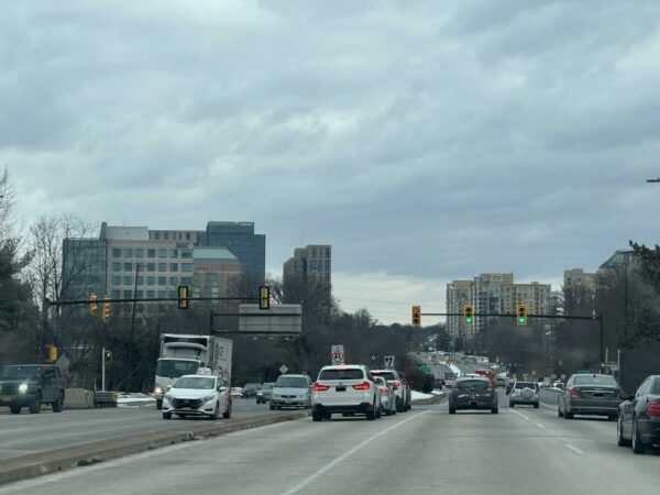
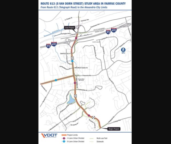
Email signup
The new, two-lane Hunter Mill Road bridge over Colvin Run (courtesy VDOT)

A critical vehicular link between Reston and the Wolf Trap area has been restored.

The new, two-lane Hunter Mill Road bridge over Colvin Run is now fully open, the Virginia Department of Transportation announced yesterday (Wednesday).

Located near Baron Cameron Avenue between Lake Fairfax Park and Colvin Run Park, the expanded bridge has one travel lane in each direction, saving drivers from the hassle and potential confusion of having to yield to oncoming traffic.

More on the project from VDOT:

The new bridge (located between the Dulles Toll Road and Baron Cameron Avenue):

  • Improves traffic flow by replacing the nearly 50-year-old weight-restricted one-lane bridge that required drivers to stop if there was traffic crossing the bridge in the other direction
  • Includes a median/splitter island separating the two lanes to improve safety

The Hunter Mill Road over Colvin Run Bridge Replacement project, which is now complete, also includes:

  • An improved trail crossing south of the bridge
  • Landscaping in the median/splitter island
  • Abutments for a future trail bridge over Colvin Run (the rest of the trail bridge will be constructed by Fairfax County)

Construction on the project began approximately two years ago in August 2021. Built in 1974, the previous bridge had just one lane and was limited to carrying 10 tons at a time, even though the road was used, on average, by 8,500 vehicles per every day, as of 2019.

One lane of the new span was completed in December.

The project cost a total of $5.2 million, relying on funds from the federal, state and Fairfax County governments.

0 Comments
A sign for the Georgetown Pike exit off of I-495 North (staff photo by Angela Woolsey)

(Updated at 11:05 a.m. on 8/7/2023) Traffic on the Capital Beltway will be periodically stopped overnight at Georgetown Pike in the latter half of next week.

Lasting up to 30 minutes at a time, the stoppages are required to enable crews to relocate utilities at the interchange as part of the 495 NEXT project, according to the Virginia Department of Transportation.

The stoppages will occur between midnight and 5 a.m. next Wednesday through Saturday (Aug. 9-12). In between each stoppage, one lane in each direction will temporarily reopen so traffic can be cleared.

(Correction: Due to a typo, this story initially said the stoppages would last until 5 p.m. instead of 5 a.m.)

“In the event of inclement weather, the stoppages and associated work will be postponed to the following night,” VDOT said. “Travelers should anticipate delays and consider taking an alternate route.”

Under construction since March 2022, the I-495 Express Lanes Northern Extension project is extending the Beltway’s toll lanes 2.5 miles north from the Dulles Toll Road in Tysons past the George Washington Memorial Parkway in McLean.

Earlier this year, McLean residents with the Northern Virginia Citizens Association sought to halt construction with a lawsuit challenging the project over its reported impacts on their health, neighborhoods and the environment.

A federal judge ruled on April 7 that work could continue during the litigation.

VDOT anticipates opening the extended express lanes in late 2025 and completing the full project in 2026.

“Drivers are urged to slow down and use caution when traveling through the 495 NEXT work zone,” VDOT said.

0 Comments
The intersection of Route 123 and Tysons Blvd outside Tysons Corner Center (staff photo by Angela Woolsey)

Local officials are in the midst of developing a data-driven way to prioritize and implement spot transportation improvements throughout Fairfax County.

The spot improvement screening program, which was discussed at a Fairfax County Board of Supervisors’ transportation committee meeting on July 18, lets the county identify priority locations for new transportation improvements, especially along intersections.

The program also intends to prioritize safety as a metric to evaluate transportation.

So far, the county has identified 287 projects as high priority out of a total of 3,966 reviewed locations. Roughly 46% of the spots already have a planned project nearby, according to the county.

The Dranesville District had the most spots, but the majority of them were categorized as “low priority.” The Franconia and Mason districts led the way in terms of high-priority spots.

A breakdown of the locations screened for spot transportation improvements by magisterial district (via FCDOT)

Underway since 2021, the county’s methodology prioritizes safety while also considering equity and the multimodal nature of the area, Fairfax County Department of Transportation staff said.

The county is in the midst of finalizing locations for each district. Evaluation and implementation is contingent on approval by the Board of Supervisors.

FCDOT staff recommend focusing on high priority locations and working with the Virginia Department of Transportation to strategize funding for projects. Staff also suggested further narrowing spots where there are no programmed safety-related projects.

If approved, the spot improvement program could get renewed every three to five years.

While the full list of possible spot improvements was not released at the meeting, Vanessa Holt from FCDOT’s traffic engineering section said that public input will be solicited on projects.

“Our program recommendations include focusing on the high priority spot locations,” Holt said.

At the meeting, supervisors asked staff to consider other elements in their evaluations. Hunter Mill District Supervisor Walter Alcorn suggested incorporating near-misses, camera data from VDOT, and other data points into the prioritization process.

“I really like the process, the drivers being data-driven,” Alcorn said.

The program, which is not yet funded, is different from the county’s active transportation program, which sets aside $100 million for improvements for pedestrians, bicyclists and other non-motorized travelers.

Board Chairman Jeff McKay also emphasized that not all traffic fatalities are linked to road safety issues.

“Unfortunately, we do have fatalities in some corridors of the county. It’s not a road design issue at all,” McKay said.

He also added that the proximity of other projects to prioritized spot improvement locations shouldn’t automatically downgrade a project from the list. Instead, the location may be a strategic area to kill two birds with the same stone.

Others like Springfield District Supervisor Pat Herrity noted that funding for these projects may not be available for several years, resulting in the need to manage public expectations about implementation.

Holt acknowledged that the public’s feedback is critical as the process moves forward.

“We recognize that data analysis is not perfect when we have that human element in transportation safety,” Holt said.

0 Comments
Cars head south on Richmond Highway (staff photo by Matt Blitz)

(Updated 10:55 a.m. on 7/26/2023) The ongoing redevelopment of Richmond Highway (Route 1) in Fairfax County has sparked a larger discussion over whether the benefits of road widening projects outweigh their potential harm.

The Virginia Department of Transportation plans to bring improvements to a three-mile stretch in the Richmond Highway corridor in two phases: first from Jeff Todd Way to just north of Frye Road, then from just north of Frye Road to Sherwood Hall Lane.

Notably, the changes will widen Richmond Highway from four to six lanes, which will pave the way for bus rapid transit in the corridor but has garnered some pushback from local community members.

The Coalition for Smarter Growth, which advocates for more “sustainable” transportation methods such as walking, biking and transit in the D.C. region, claimed in a recent press release that “wider roads fail, and the public knows this.”

CSG’s Northern Virginia Advocacy Manager Sonya Breehey says road widening projects create induced demand, arguing that adding more travel lanes incentivizes more people to drive and increases congestion in the long run, despite offering short-term relief.

“The idea is, we get stuck in traffic, so we add travel lanes,” Breehey said. “It’s easy for a few years, but then those travel lanes fill back up and then everybody’s clamoring again for more road widening. It’s a cyclical problem.”

Rep. Don Beyer, who represents the county’s Route 1 area in Congress, told FFXnow in an exclusive interview that he supports road widening projects.

“I think [road widening projects] are an important part of congestion relief,” Beyer said. “There’s an alternative argument…that they will fill up as fast as you build them. That’s certainly been largely true in the metro D.C. area for a long time…but at the same time, I don’t know if it’s still true today.”

In addition to adding travel lanes, the Richmond Highway project reserves median space for future lanes dedicated to The One, a bus rapid transit system that aims to outpace traditional bus services with dedicated lanes and fewer stops.

The planned Richmond Highway bus rapid transit map (via FCDOT)

With the BRT expected to be operational in 2030, the Northern Virginia Transportation Commission announced last month that the Commonwealth Transportation Board approved $10 million to help implement the bus system from Fort Belvoir to the Huntington Metro station.

“This billion-dollar investment in a new state-of-the-art transportation system and in the communities along Richmond Highway will revitalize the area and provide more safe, convenient and dependable transportation options for the people who live here,” Mount Vernon District Supervisor Dan Storck wrote in a statement.

Storck says road widening can only be “done right” if it is “in coordination” with “walkable, bikeable communities and mass transit.” Read More

0 Comments

The new Nutley Street interchange at I-66 just south of Vienna is about to achieve its final form.

Lanes that will let drivers going from Nutley to I-66 bypass the dreaded roundabouts are scheduled to open tomorrow (Wednesday), the Virginia Department of Transportation recently announced.

With the added bypass lanes, the interchange will be in its “permanent configuration,” VDOT said.

The area has been under construction since 2019 as part of the Transform 66 Outside the Beltway project, which added 22.5 miles of toll lanes on I-66 from the Capital Beltway in Dunn Loring to Route 29 in Gainesville.

In preparation for the bypass lanes, there have been some lane closures on Nutley Street so crews can finish paving the roadway.

Starting at 9 p.m. today (Tuesday) until 5 a.m. tomorrow, the northbound lanes from Saintsbury Drive to the bridge and the southbound lanes from Virginia Center Blvd to the bridge will be closed.

Northbound drivers will be detoured left onto Saintsbury Drive and then right onto Vaden Drive and Virginia Center Boulevard to get to Nutley, while southbound drivers will be directed along the same route in the opposite direction.

“Drivers should expect delays if traveling in this area and are encouraged to use alternate routes,” VDOT said. “All work is weather dependent and will be rescheduled to the following day should inclement conditions occur.”

Though community members have called the roundabouts “dangerous” and a “mess,” VDOT said the new configuration will provide “safer, more efficient travel” for vehicles entering and exiting I-66, as well as drivers and pedestrians on Nutley.

Compared to straight-on intersections, roundabouts reduce serious crashes by slowing vehicles down and minimizing points of conflict, according to the Federal Highway Administration.

As part of the Transform 66 project, VDOT has also been constructing a shared-use path along I-66, opening the first completed section on May 17. Crossings at the Nutley interchange are slated to open in the middle of this month.

0 Comments
A new study seeks to alleviate congestion and safety issues along sections of Franconia Road and Commerce Street (via VDOT)

The Virginia Department of Transportation (VDOT) is asking for public input on how to reduce congestion and the number of crashes on two half-mile sections of road in Springfield.

A new survey is open through June 15, asking residents about their traveling habits and safety concerns along Franconia Road between Backlick Road and Loisdale Road. The survey also focuses on Commerce Street between Amherst Avenue and Franconia Road.

The survey marks the beginning of a STARS (Strategically Targeted Affordable Roadway Solutions) study that will help develop “proposed improvements that localities can pursue for funding,” a press release says.

Those two sections of roads, particularly Franconia Road, are of concern because they often have traffic congestion due to the nearby I-95 interchange. There’s also a high number of crashes, according to VDOT.

That half-mile section of Franconia Road averages about 69,000 vehicles a day and has had 162 crashes between January 2015 and October 2022, per a VDOT presentation. That includes at least one fatal crash and several that resulted in severe injuries.

The portion of Commerce Street in the study has much less volume, with only about 19,000 vehicles every day. But there have been even more crashes along the road during that same time period.

A large number of the 171 crashes have resulted in property damage only, but several did lead to severe injury.

VDOT is looking into a number of improvements along those roads focused on safety, the presentation notes.

That includes “innovative intersections” that have different shapes or traffic flow patterns. It could also mean adding Rectangular Rapid Flashing Beacons, high-visibility crosswalks and improved bicycle facilities, including better bicycle lane transitions and pavement markings.

What exactly will be done will, at least partially, depend on the results of the public survey, VDOT said.

In the questionnaire, respondents are asked to rank their top concerns, with traffic congestion, pedestrian safety, public transit access, and speeding among the options listed. They are also asked when they typically traveled along those roads, by what method of transportation, and when they typically experience congestion.

The survey “will be used to help develop potential safety and operational alternatives that will be evaluated and presented during the second round of public involvement scheduled for this winter,” the project website reads.

The study is set to be completed in spring 2024. No construction timeline has been set as of yet, per the press release.

0 Comments
Project area for the East Spring Street widening in Herndon (via VDOT)

Rising construction costs have created a funding gap for the widening of East Spring Street.

The Town of Herndon is seeking roughly $3.1 million in federal funding for the project, which is administered by the Virginia Department of Transportation.

The move will require a 20% match from the town. In a memo to the Herndon Town Council, staff said that the funding shortfall was caused by increasing construction costs.

“The full amount of the funding gap would otherwise be borne by the Town of Herndon,” staff said in the March 16 memo.

The project would be funded under the federal Community Project Funding program, which selects projects through a congressionally-directed application process.

The nearly $11.5 million project will widen Spring Street and Herndon Parkway at the intersection of those two roads.

It will also add a cycle track on Herndon Parkway to connect with the Sugarland Run Stream Valley Trail, high-visibility crosswalks, a sidewalk on the south side of Spring Street to connect with the county sidewalk under Fairfax County Parkway, and new traffic signals and accessible pedestrian signals.

The project is currently under construction and is expected to warp up in late 2024, according to VDOT. 

0 Comments

The first segment of the Virginia Department of Transportation’s planned shared-use trail along I-66 has been completed.

State and Fairfax County officials will celebrate the milestone today (Wednesday) with a ribbon-cutting ceremony at 11 a.m., followed by an inaugural bicycle ride or walk on the finished section, which starts east of the Vienna Metro station and extends to Cedar Lane near Merrifield.

The segment includes a tunnel under Nutley Street, one of several below-grade crossings planned for the 11-mile, mostly 10-foot-wide trail being built from Gallows Road in Dunn Loring to Route 29 in Centreville.

More portions are expected to be finished later this month, including a crossing at an I-66 entry ramp at the Nutley Street interchange and a segment from Blake Lane to Route 123 in Oakton.

“The 66 Parallel Trail and new bike and pedestrian access across the I-66 bridges supports VDOT’s commitment to providing multimodal travel options to ‘move more people — not just vehicles,'” VDOT said in a statement to FFXnow.

VDOT’s private partner I-66 Express Mobility Partners (I-66 EMP) and construction contractor FAM Construction built the 66 Parallel Trail — a name chosen by a Fairfax County survey — as part of the Transform 66 Outside the Beltway project, which added 22 miles to the I-66 Express Lanes.

Including sidewalks being added on bridge crossings over I-66, the project will deliver 18 miles of new pedestrian and bicycle facilities, according to VDOT.

The trail’s inclusion in the highway widening project came after a campaign by local pedestrian and bicycling advocates, including the nonprofit Fairfax Alliance for Better Bicycling (FABB).

“The new 66 Trail will significantly improve east-west connectivity for people walking and biking in the corridor that does not exist today,” said former FABB President Sonya Breehey, who’s now the Northern Virginia advocacy manager for the Coalition for Smarter Growth. “The trail opens up the opportunity to walk, bike, roll to the Metro, schools, parks, restaurants, retail, and other places throughout the corridor.”

The 66 Parallel Trail will span 11 miles across Fairfax County when completed (via VDOT)

The design process for the trail was contentious, as cycling advocates pushed to keep it outside the I-66 soundwalls. However, adjacent homeowners objected to giving up part of their backyards, fearing a loss of privacy and green space.

The final design placed approximately three miles directly next to the highway, while about eight miles will be behind a noise barrier or have no noise barrier.

Breehey calls the trail’s placement inside the soundwalls an “unfortunate compromise,” but VDOT mitigated some concerns by elevating some portions above the highway and putting others behind a 50-inch concrete barrier. Read More

0 Comments
The speed limit on Richmond Highway will be reduced to 35 mph from Jeff Todd Way/Mount Vernon Memorial Highway to the Alexandria city limits (via VDOT)

The speed limit on Richmond Highway (Route 1) has been permanently lowered through much of Fairfax County.

Starting next Tuesday (May 23), the legal limit will be reduced from 45 to 35 mph along a roughly 7-mile stretch between the Alexandria City limits at the Capital Beltway (I-495) and Jeff Todd Way/Mount Vernon Memorial Highway, the Virginia and Fairfax County transportation departments announced yesterday (Monday).

The departments said the change is designed “to optimize safety and operations for pedestrians, bicyclists, drivers and transit users” along a corridor that routinely sees devastating crashes.

Just this year, there have been at least 102 vehicle crashes on the Fairfax County section of Richmond Highway, injuring 75 people, according to state data. Prior to 2018, the total number of crashes consistently topped 400, peaking at 508 crashes in 2012.

So far in 2023, three people have been killed on the roadway: two pedestrians and a motorcyclist. Since 2011, there have been about 37 fatalities.

The Virginia Department of Transportation recommended in July 2022 that the speed limit be lowered after a year-long speed study found crashes occur more frequently on Richmond Highway than other primary highways in Northern Virginia, on average.

“The team also found that Richmond Highway between Buckman Road/Mount Vernon Highway and the Alexandria southern city limits had a higher incidence of pedestrian [and] bicycle crashes and speed-related crashes compared to other sections of Richmond Highway,” VDOT said.

However, the study recommended maintaining the existing 45-mph speed limit in the Fort Belvoir area from Belvoir Road to Jeff Todd Way. That 0.75-mile stretch had a lower crash rate, though about 50% of vehicles still exceed the speed limit, according to VDOT.

At a public meeting last summer, some community members raised concerns about the lower speed limit increasing congestion and questioned how effectively it’ll be enforced, but VDOT officials said the study indicated the change will have a “minimal” impact on traffic and allow tougher penalties on drivers who violate the limit.

Even a small decrease in vehicle speeds can lead to fewer serious crashes, according to the National Highway Traffic Safety Administration. A 5-mph reduction from 40 mph, for example, will produce an estimated 34% reduction in crashes with injuries.

Signs showing the new speed limit will be placed along Richmond Highway on May 23, VDOT said. A final report on the speed study is expected to be finished around the middle of this year.

0 Comments
Route 7 construction workers (staff photo by Angela Woolsey)

For the next few months, drivers will have just one road to reach Route 7 (Leesburg Pike) from Wolf Trap.

The access point at Trap Road is scheduled to close at 7 a.m. tomorrow (Wednesday) and will remain blocked to traffic until 9 a.m. Saturday (April 22), the Virginia Department of Transportation announced last week.

Drivers will be required to use Towlston Road in order to travel between Route 7 and Trap Road.

“By Saturday, April 22 at 9 a.m., the eastbound lanes of Route 7 will shift to the south, and Trap Road will reopen at Route 7 to incoming traffic,” VDOT said. “Drivers on eastbound Route 7 will be able to turn right onto Trap Road.”

However, Trap Road will remain closed to outgoing traffic, which will still need to use Towlston through this summer. A full reopening is currently anticipated in August, according to VDOT.

Traffic between Route 7 and Trap Road will be detoured to Towlston Road from April 19-22 (via VDOT)

The closure is part of the ongoing project to widen Route 7 from four to six lanes along a nearly 7-mile stretch from Reston Avenue to Jarrett Valley Drive. Under construction since 2019, the project is also adding 10-foot-wide shared-use paths on both sides of the roadway and redesigning key intersections.

New traffic patterns necessitated by a reconstruction of the Baron Cameron Avenue intersection will be in place until 5 a.m. Thursday (April 20). The new Lewinsville Road intersection is on track to open in May.

The overall Route 7 widening is expected to be completed by July 31, 2024, according to the project website. It costs an estimated $313.9 million.

0 Comments
×

Subscribe to our mailing list