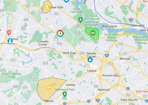
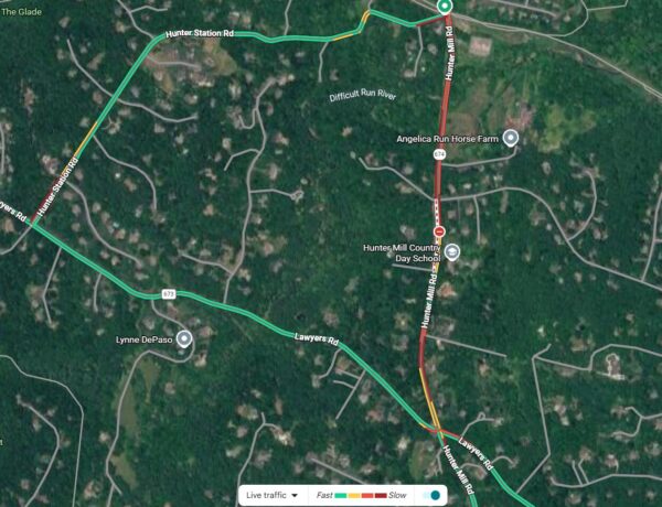
Email signup
U.S., Virginia and Fairfax County flags on a pole blow in wind on a rainy day (staff photo by Angela Woolsey)

Updated at 10:25 a.m. on 2/28/2024 — The National Weather Service has moved up the start time for its Wind Advisory to 3 p.m. today (Wednesday).

Earlier: A Wind Advisory has been issued for the D.C. area, including Fairfax County.

The alert is currently scheduled to start at 6 p.m. tomorrow (Wednesday) and continue until 4 a.m. Thursday (Feb. 29), according to the National Weather Service.

“Gusty winds could blow around unsecured objects. Tree limbs could be blown down and a few power outages may result,” the NWS said, warning that winds could reach 20 to 30 mph with gusts of up to 50 mph.

The strong winds will conclude what’s expected to be a rainy day in the county. The NWS is forecasting a 100% chance of rain tomorrow, but temperatures could still reach a high of 63 degrees, continuing an abnormally warm February for the East Coast.

A cold front is anticipated following tomorrow night’s high winds, bringing temperatures slightly down on Thursday, according to the Capital Weather Gang.

The full Wind Advisory is below.

…WIND ADVISORY IN EFFECT FROM 6 PM WEDNESDAY TO 4 AM EST THURSDAY…

* WHAT…West winds 20 to 30 mph with gusts up to 50 mph expected.

* WHERE…Portions of central, north central, northeast and northern Maryland, The District of Columbia, central, northern, northwest and western Virginia and eastern and panhandle West Virginia.

* WHEN…From 6 PM Wednesday to 4 AM EST Thursday.

* IMPACTS…Gusty winds could blow around unsecured objects. Tree limbs could be blown down and a few power outages may result.

PRECAUTIONARY/PREPAREDNESS ACTIONS…

Use extra caution when driving, especially if operating a high profile vehicle. Secure outdoor objects.

0 Comments
A Fairfax Connector bus travels on Maple Avenue during a rain storm on Jan. 6, 2023 (staff photo by Angela Woolsey)

In case you didn’t get your fill of rain on Saturday (Jan. 6), another downpour could be in store for Fairfax County this week.

The National Weather Service has issued a Flood Watch and a Wind Advisory for the mid-Atlantic region, including Fairfax County and the rest of northern Virginia, ahead of a storm that’s expected to travel up the East Coast tomorrow (Tuesday).

Issued this morning, the Flood Watch is currently set to take effect at 1 p.m. tomorrow and remain in place until 7 a.m. Wednesday (Jan. 10). The alert warns that flooding caused by “excessive rainfall” of two to three inches is possible.

The forecast indicates that the heaviest period of rain will come in the afternoon and evening.

“Excessive runoff may result in flooding of rivers, creeks, streams, and other low-lying and flood-prone locations,” the NWS said. “Creeks and streams may rise out of their banks. Flooding may occur in poor drainage and urban areas. Low-water crossings may be flooded.”

The Wind Advisory will be in place from 3 p.m. tomorrow to 1 a.m. Wednesday. Southeast winds may reach 20 to 30 mph with gusts up to 50 mph, according to the NWS.

“Gusty winds could blow around unsecured objects. Tree limbs could be blown down and a few power outages may result,” the alert says.

According to the Capital Weather Gang, the incoming storm will be similar to the one that hit on Saturday, fueled by warm air from the south that will turn most of the precipitation into rain.

Forecasts last week suggested Fairfax County could get up to an inch of snow and sleet accumulation from Saturday’s winter storm. NWS data for the Dulles Airport area indicates that the 0.97 inches of precipitation recorded that day was mostly rain, though there were “trace” amounts of snow.

0 Comments
Tropical Storm Ophelia is expected to bring rain and wind to Northern Virginia this weekend (via National Weather Service)

Updated at 4:05 p.m. — A Coastal Flood Advisory issued for parts of Northern Virginia, including Fairfax County, will now take effect at midnight, earlier than initially anticipated, the National Weather Service says.

Earlier: It’s going to be a cold and rainy weekend in Fairfax County, thanks to Tropical Storm Ophelia.

Tracking to make landfall in North Carolina today (Friday), the storm is expected to reach Northern Virginia tonight with “heavy rain, high winds, and cool temperatures” continuing into Sunday (Sept. 24) morning, according to the Fairfax County Department of Emergency Management.

“Locally, [the National Weather Service] expects 2-4 inches of rain throughout the weekend,” the county said in a post on its emergency information blog. “Since the precipitation will be spread across the weekend, flooding is not a major concern but could cause some localized flooding issues. Wind speeds will gradually increase, peaking around 40 mph on Saturday.”

The storm has already affected some major events, prompting cancellations of the popular Reston Multicultural Festival, the inaugural Fairfax Fiesta in Tysons and a kick-off for National Public Lands Day in Annandale. Other events, like Fairfax City’s Fiesta Fairfax, have been relocated indoors.

The NWS has issued a Coastal Flood Advisory and a Wind Advisory for much of the D.C. area, including Fairfax County.

The flood advisory will be in effect from noon tomorrow (Saturday) to 5 a.m. Sunday:

* WHAT…Up to one half foot of inundation above ground level expected in low lying areas due to tidal flooding.

* WHERE…Fairfax, Stafford and Central and Southeast Prince William/Manassas/Manassas Park Counties.

* WHEN…From noon Saturday to 5 AM EDT Sunday, especially around the time of high tide.

* IMPACTS…Flooding of lots, parks, and roads with only isolated road closures expected.

* ADDITIONAL DETAILS…Tides one and a half to two feet above normal. The worst flooding will occur with the Saturday afternoon and Saturday night high tides.

The Wind Advisory will take effect at 8 a.m. tomorrow and last until 8 p.m., warning that northeast winds could reach 20 to 30 mph with up to 45-mph gusts. The NWS notes that the “gusty winds” could blow around objects and result in power outages. Read More

0 Comments
U.S., Virginia and Fairfax County flags blow in wind (staff photo by Jay Westcott)

The time to get any patio furniture and other loose, outdoor objects inside is now.

At 2:29 p.m. today (Friday), the National Weather Service issued a High Wind Warning for the D.C. area, including Fairfax County, in anticipation of an encroaching storm.

Set to take effect from noon tomorrow (Saturday) until midnight, the alert warns of wind gusts that could reach up to 60 mph, raising the potential for power outages and travel difficulties.

…HIGH WIND WARNING IN EFFECT FROM NOON SATURDAY TO MIDNIGHT EDT SATURDAY NIGHT…

* WHAT…Southwest winds 20 to 30 mph with gusts up to 50 mph Saturday afternoon, becoming northwest 25 to 35 mph with gusts up to 60 mph Saturday evening.

* WHERE…Portions of central and northern Maryland, The District of Columbia, and northern Virginia.

* WHEN…From noon Saturday to midnight EDT Saturday night. The strongest winds are expected Saturday evening.

* IMPACTS…Damaging winds will blow down trees and power lines. Widespread power outages are expected. Travel will be difficult, especially for high profile vehicles.

“People should avoid being outside in forested areas and around trees and branches,” the NWS said. “If possible, remain in the lower levels of your home during the windstorm, and avoid windows. Use caution if you must drive.”

The storm has been moving east after slamming California with heavy winds, rain and snow earlier this week. Nearly 90 million people across 21 states are under a hazardous weather alert, as the Midwest and some Southern states face the risk of tornadoes just a week after one killed at least 26 people in Mississippi and Alabama.

0 Comments
High winds are causing power outages in Fairfax County, including in Great Falls and Oakton (via Dominion Energy)

(Updated at 2:35 p.m.) Hundreds of people in Fairfax County have lost electricity today (Tuesday) as winds buffet the D.C. region, taking out power lines and contributing to at least one fire.

Georgetown Pike is currently closed in both directions at Miller Avenue in Great Falls due to a tree that fell on power lines and “a resulting fire,” the Virginia Department of Transportation said shortly after 1 p.m.

The closure extends between Stephanie Circle and Ellsworth Avenue, according to the Fairfax County Police Department.

“Expect delays for several hours as emergency and utility crews clear the scene,” VDOT tweeted.

That one outage has affected 277 Dominion Energy customers, according to the utility company’s outage map. Power isn’t expected to be restored there until 4-9 p.m.

Further south in the Vienna and Oakton area, Dominion crews are assessing the damage caused by the wind storm in the Lake Vale neighborhood. Power is now being restored to over 800 customers.

Vale Road has been closed between Hunter Mill Road and Stryker Avenue due to fallen power lines, according to Fairfax County police.

“The closure is expected to last several hours. Please use an alternate route,” the FCPD said.

While those are the largest outages reported so far, power losses and road closures due to fallen wires have been seen across the county today. As of 1:50 p.m., about 1,268 Dominion Energy customers in the county were without power.

The National Weather Service issued a Wind Advisory that took effect at 9 a.m. today and will remain in place until 2 a.m. tomorrow (Wednesday).

Winds have been consistently exceeding 40 mph, with some gusts topping 50 mph, according to the Washington Post’s Capital Weather Gang.

0 Comments
The artwork, pictured in its complete form, was removed from the platform (courtesy Public Art Reston)

Cerebral, a public art piece created by South Lakes High School’s STEAM club on the Lake Thoreau spillway, is officially no more.

There are no plans to install the sculpture after high winds loosed its joints and its pieces fell into the lake and beyond last weekend, according to SLHS art teacher Marco Rando.

The sculpture is the first to fail because of the elements and the seventh installation overall placed by the club on the spillway.

Rando said that, although the sculpture is designed and engineered for extreme elements using hurricane ties, the winds damaged some of the joints.

“The tie down cables worked to keep the elements secured to the concrete base even when half sculpture fell into the lake,” Rando said. “Fortunately the wood members of the sculpture allowed the work to float, this helped in towing the work to shore where it was disassembled in smaller pieces for transport back to the school.”

Because of the significant damage to the sculpture, the team decided not to focus on reassembling.

But it won’t be long before another sculpture will take its place. Students are currently working on a new concept — “Rise” — that will face “more engineering scrutiny” to buttress the sculpture to weather more natural elements.

“The team is very confident this year’s concept will be aesthetically beautiful with added structural details to withstand the erratic weather conditions that seem to be common of the current climate change. The students of STEAM Team take great pride in serving the community,” Rando said.

He says setbacks like the structural failure of an artwork are a learning experience for all.

“Such setbacks will only strengthen the students experience, this real world problem, which occurs on professional levels as well, affords the Team opportunity to examine and resolve issues before they are unsettled,” Rando said.

0 Comments

The high winds on Friday (Feb. 17) proved too much for public artwork installed by South Lakes High School’s STEAM club on Lake Thoreau’s spillway.

After high winds blew off several pieces of the artwork “Cerebral,” the exhibit was removed from the platform. Composed of aircraft cable, barrel swivels, wire, paint, solar panels and wood, the artwork was installed in June.

“RA’s CSF team safely recovered all the artwork pieces that ended up in the lake and removed the remaining pieces from the spillway on Saturday morning,” RA spokesperson Mike Leone said.

The pieces were returned to the school. As of now, it’s unclear if reinstallation is planned. Another artwork is planned for the same area this summer.

The county was under a wind advisory throughout Friday evening. Winds were reportedly traveling at 20 to 35 mph with gusts up to 50 mph, according to the National Weather Service. 

Developed under the guidance of SLHS art teacher Marco Rando, the sculpture aims to conceptualize the complexity of the brain. The brain and body is depicted as a cohesive force, challenging the idea of humans being left brained or right brained, according to nonprofit organization Public Art Reston.

The artwork is the eighth installed by the STEAM club. Students present designs to Public Art Reston and Reston Association’s Design Review Board for approval. According to Public Art Reston, the design is tested for durability, constructed by students, disassembled and then reinstalled on the spillway.

0 Comments
A severe thunderstorm warning and a wind advisory have been issued for Fairfax County (via National Weather Service)

The National Weather Service issued a Wind Advisory and a Severe Thunderstorm Watch for Fairfax County and surrounding areas this afternoon (Thursday).

The Wind Advisory warns of winds between 15 to 25 mph with gusts up to 50 mph and is in effect until 8 p.m., while the Thunderstorm Watch is in effect until 10 p.m.

“Gusty winds could blow around unsecured objects,” the advisory reads. “Isolated tree damage and a few power outages may result.”

The warning advises to use extra caution when driving and to secure outdoor objects.

Read the full wind advisory below.

Event: Wind Advisory
Alert: …WIND ADVISORY IN EFFECT UNTIL 8 PM EDT THIS EVENING…

* WHAT…South winds 15 to 25 mph with gusts up to 50 mph
expected.

* WHERE…District of Columbia, and portions of central, northern
and southern Maryland, central and northern Virginia and
panhandle West Virginia.

* WHEN…Until 8 PM EDT this evening.

* IMPACTS…Gusty winds could blow around unsecured objects. Isolated tree damage and a few power outages may result. Instructions: Use extra caution when driving, especially if operating a high profile vehicle. Secure outdoor objects.

0 Comments
Cunningham Park Elementary School grounds after a previous snowstorm (staff photo by Angela Woolsey)

(updated at 6:40 p.m.) The National Weather Service has issued winter weather and wind advisories for Fairfax County tomorrow (Saturday).

NWS warns that there may be snow accumulations of between 2 to 4 inches. The winter weather advisory is between 7 a.m. and 3 p.m. Saturday, coinciding with a wind advisory that will take effect between 6 a.m. to 1 a.m. on Sunday.

Fairfax County Public Schools has canceled all activities that were set to take place on school grounds Saturday, including SAT testing, extracurriculars and recreation and community uses.

The county sent out a news release warning that they expect the incoming weather “will bring heavy winds, with gusts up to 55 mph.”

See the full NWS winter weather advisory is below.

…WINTER WEATHER ADVISORY IN EFFECT FROM 7 AM TO 3 PM EST SATURDAY…

* WHAT…Snow expected. Total snow accumulations of 2 to 4 inches. Northwest winds will gust around 45 to 55 mph.

* WHERE…Portions of central and northeastern Maryland, northern and central Virginia, and the District of Columbia, including most of the DC and Baltimore metros.

* WHEN…From 7 AM to 3 PM EST Saturday. Rain will change to snow between 7 and 9 AM early Saturday. The steadiest snow will be through Saturday morning.

* IMPACTS…Plan on slippery road conditions. Gusty winds could bring down tree branches.

* ADDITIONAL DETAILS…Visibility may be reduced to below one- quarter mile at times. Brief near blizzard conditions are possible between 8 and 11 AM.

PRECAUTIONARY/PREPAREDNESS ACTIONS…

Slow down and use caution while traveling.

When venturing outside, watch your first few steps taken on steps, sidewalks, and driveways, which could be icy and slippery, increasing your risk of a fall and injury.

0 Comments

Fairfax County could be hit by wind gusts of up to 55 miles per hour this weekend, courtesy of stormy weather that could pass through the D.C. region ahead of an expected cold front.

A Wind Advisory has been issued for the area, starting at 4 p.m. tomorrow (Saturday) and continuing until 1 a.m. Sunday (Dec. 12).

The National Weather Service says to prepare for west winds of 15 to 25 miles per hour, with gusts that could reach up to 55 miles per hour. The highest wind speeds are expected to come between 6 p.m. and midnight.

“Gusty winds could blow around unsecured objects,” the NWS said in its alert. “Tree limbs could be blown down and a few power outages may result.”

According to the Capital Weather Gang, the high winds will contribute to a rise in temperatures, which current forecasts indicate could hit an unseasonable high of 70 degrees Fahrenheit on Saturday even with a 70% chance of precipitation during the day.

Temperatures are expected to drop back into the 40s on Sunday.

0 Comments
×

Subscribe to our mailing list