Fairfax County’s plan for bus rapid transit (BRT) service on Route 7 in Tysons sailed through the planning commission last week.
The commissioners recommended on Wednesday (June 21) that the Fairfax County Board of Supervisors approve a comprehensive plan amendment establishing guidelines for the future public transportation system, including the route and station locations.
If the amendment is approved at the board’s scheduled public hearing on July 25, the project will become eligible for funding through the county’s Transportation Priorities Plan and state and regional grants, Fairfax County Department of Transportation senior planner Sean Schweitzer told the planning commission.
“This is for future planning. This is not an immediately funded initiative. It’s also very timely,” Planning Commission Vice Chairman Timothy Sargeant noted, referencing FCDOT’s collaboration with the Northern Virginia Transportation Commission on a larger study that could eventually extend the Route 7 BRT to Alexandria.
Known as Envision Route 7, that study has been underway since 2013 and shifted its focus last fall to a portion of the system that will run through Falls Church City down to Seven Corners.
Because the Tysons section is at a more advanced stage of planning, with an overall route alignment in place since 2021, Fairfax County hopes to initially implement service within Tysons down to the West Falls Church Metro station as a temporary southern terminus.
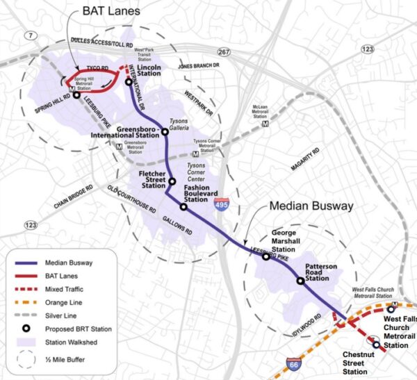
As shared with the planning commission at a committee meeting on May 11 and with the public at virtual community meetings on June 7 and 8, the Route 7 BRT will serve nine stops in the Tysons area:
- West Falls Church Metro
- Route 7 (Leesburg Pike) at Chestnut Street
- Patterson Road, near the Tysons Station and Idylwood Plaza shopping centers
- George C. Marshall Drive
- Fashion Blvd, serving Tysons Corner Center
- International Drive and Fletcher Street
- International and Greensboro Drive, next to Tysons Galleria
- International and Lincoln Circle
- Spring Hill Metro station
To give the buses a clear path, since BRT is intended to be faster than a regular local bus service, the county has proposed designating two future lanes on Route 7 (Leesburg Pike) as BRT-exclusive lanes. The service will also repurpose two existing lanes on International Drive to Lincoln Circle.
The buses will occasionally enter mixed traffic at the West Falls Church station and when turning left from International Drive onto Spring Hill Road, where they will use Business Access and Transit (BAT) lanes to reach the Metro station.
“We know that the middle of Tysons doesn’t really have too much in the way of transit options,” Schweitzer said. “So, this preferred alignment helps to kind of expand the overall transit network within Tysons and gives people…different modes to use in order to get around Tysons and, ultimately, in the future, to Alexandria.”
FCDOT staff is studying how to incorporate improvements for bicyclists and pedestrians into the project, Schweitzer told the commission. Also to be determined is whether the BRT will keep stopping at the West Falls Church Metro station or stay on Route 7 after service is extended into Falls Church.
Franconia District Commissioner Dan Lagana suggested the county could learn from the existing BRT systems in Arlington and Alexandria when designing bicycle and pedestrian facilities, such as wider or raised crosswalks.
“I use and drive by, for example, the Metroway in Alexandria frequently, and…the city has done an outstanding job, Arlington and Alexandria,” Lagana said. “But there are some clear gaps now that we’ve seen it in action and we know crosswalks in the area are insufficient.”
Schweitzer said the county has been collaborating with its neighbors in Arlington, Alexandria and Falls Church, including through the Envision Route 7 study.
“We’re making sure all our transit projects and studies are kind of lining up so it can create, in the future, an expansive BRT system and also connect to the West End Metroway as well in Alexandria,” he said.
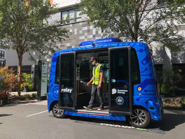
Fairfax County is winding down its groundbreaking experiment with self-driving public transportation.
The autonomous, electric Relay shuttle will cease operations after June 23, concluding almost three years of bussing passengers around the Dunn Loring Metro station and the Mosaic District in Merrifield.
Since launching on Oct. 22, 2020, the shuttle has provided 356 trips, as of last Thursday (June 1). While attracting riders was a struggle at times, the pilot project was successful at demonstrating the potential and challenges of using the technology for public transit, Fairfax County Department of Transportation Chief of Operations John Zarbo says.
“I would think we would determine it as a success,” Zarbo told FFXnow. “Our ultimate goal of the project was sort of to be a test bed and to learn about the technology and sort of have an infrastructure area that we could see what the vehicle did. Ridership was extremely important to us, but it wasn’t everything…There was so much more to it.”
The first state-funded test of its kind in Virginia, the Relay pilot was intended to last just one year but got funding for multiple extensions, as the county and Dominion Energy, which owns the vehicle, waited out the hit that public transportation took nationally during the pandemic.
According to Zarbo, ridership has increased in recent months as the sense of COVID-19 as an emergency has faded. He also attributes the uptick to changes to the shuttle’s route and schedule that took effect on Dec. 5.
Originally, the shuttle traveled from the Dunn Loring Metro down Merrilee Drive, crossed Route 29 onto Eskridge Road, and looped around Merrifield Cinema Drive to stop by the Mosaic District’s Barnes and Noble.
The project team expanded the route to include three stops along District Avenue, giving them the chance to see how the vehicle handled a busier street.
“The vehicle does really well interacting with the pedestrians, which was a concern of ours at the beginning, but it did really well adjusting and driving autonomously on its own with very little interaction from the safety steward,” Zarbo said, referring to the on-board operator who assists riders and can take manual control if needed.
The current schedule of 10 a.m. to 2 p.m. on Tuesday through Friday also “definitely worked better” than the original Monday to Thursday timeline, according to Zarbo, though the county wasn’t able to get approval for Saturdays.
The vehicle technology, provided by EasyMile, also improved throughout the pilot. A software upgrade enabled the shuttle to better navigate vegetation so it didn’t detect every overhanging tree branch as an object to be avoided. Read More

Plans for a Route 7 bus rapid transit (BRT) system in Tysons are starting to take more concrete shape, outpacing an ongoing study of the corridor further to the south.
The service will initially launch in Tysons, operating between the Spring Hill and West Falls Church Metro stations, before later expanding into Falls Church and Alexandria, Fairfax County Department of Transportation staff told planning commission members at a May 11 committee meeting.
“Since the northern portion is kind of on a fast track, we would make this the first phase to see how it works,” Sean Schweitzer, a senior transportation planner for FCDOT, said. “It would work in the interim as a closed system until the rest can catch up.”
During the interim phase, the BRT will have nine stops, according to a comprehensive plan amendment proposed by county staff:
- The West Falls Church Metro station
- Westbound Route 7 (Leesburg Pike) at Chestnut Street
- Patterson Road, near the Tysons Station and Idylwood Plaza shopping cneters
- George C. Marshall Drive
- Fashion Blvd, serving Tysons Corner Center
- International Drive and Fletcher Street
- International and Greensboro Drive, next to Tysons Galleria
- International and Lincoln Circle
- Spring Hill Metro station
In the future, the Fletcher Street station could serve as a transfer point for an “enhanced” Gallows Road transit system, Schweitzer said. A study of that corridor down to Annandale is only just gearing up.
The route follows the preferred alignment along International Drive that the Fairfax County Board of Supervisors approved in 2021. The West Falls Church Metro was chosen as an interim southern terminus so buses can turn around, but the county hasn’t ruled out the possibility of making it a permanent station.
“If [the BRT is] better served by going directly to the Metro station, where it can pick up more passengers versus staying on Route 7, we could make that adjustment and have that be the ultimate alignment,” Fairfax County Transportation Planning Chief Mike Garcia said.
Except for the Metro stations, each stop will have separate platforms for east and westbound travel, staggered to reduce right-of-way needs, according to county staff.
The buses will mostly utilize dedicated median lanes, but they have to join other traffic at the Metro stations and to make the left turn from International Drive to Spring Hill Road. Spring Hill and Tyco roads will have “Business Access and Transit” (BAT) lanes limited to buses and drivers turning into the commercial area east of the Spring Hill Metro station. Read More
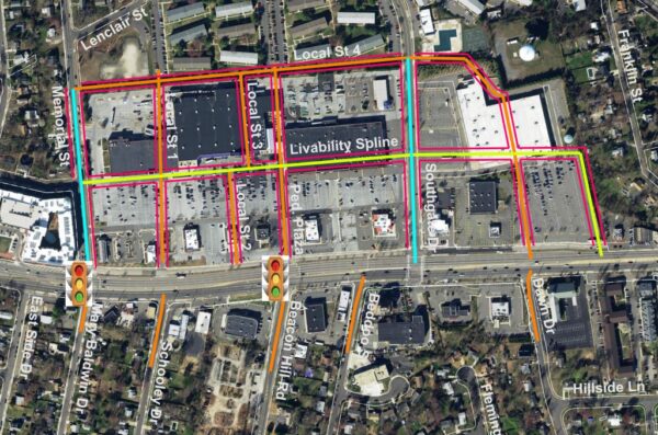
Fairfax County is working through a list of dozens of projects that could bring transportation infrastructure improvements to Richmond Highway (Route 1).
County planners plan to discuss the Richmond Highway Transportation Plan at virtual meetings tonight (Wednesday) and tomorrow (May 25).
The Fairfax County Board of Supervisors approved the Embark Richmond Highway Comprehensive Plan in 2018. As part of that approval, the board directed county transportation staff to develop a funding plan for improvements throughout the corridor.
So far, the recommended projects and conceptual designs in the corridor include missing links between sidewalks so residents can take advantage of planned Bus Rapid Transit (BRT) stations and existing shopping centers.
Branded “The One,” the BRT will include nine stations between Huntington Metro Station and Fort Belvoir.
Projects for additional sidewalks are below:
- North Gateway CBC sidewalks
- Huntington TSA sidewalks
- Penn Daw CBC sidewalks
- Hybla Valley/Gum Springs CBC sidewalks
- Beacon/Groveton CBC sidewalks
- South County CBC sidewalks
- Woodlawn CBC sidewalks
A second class of projects builds more streetscapes between Community Business Center (CBC) areas, largely through private developers. But a quarter of the projects are included in the funding plan in the event that small elements need to be built by the county:
- North Gateway Grid of Streets
- Penn Daw Grid of Streets
- Beacon/Groveton Grid of Streets
- Hybla Valley/Gum Springs Grid of Streets
- Woodlawn Grid of Streets
The final class of projects include a mix of pedestrian connections, paths and trails:
- Buckman Road Bike/Ped Improvements
- Dart Drive Bike/Ped Improvements
- South Kings Highway Bike/Ped Improvements
- Lukens Lane Bike/Ped Improvements
- Ashton-Grey Goose-Hybla Valley Trail
- Pole Road Shared Use Path
- Old Mill Road Shared Use Path
- Jeff Todd Way Shared Use Path
- Douglas Street-Derek Road Connector Trail
- Davis Street-Arlington Drive Connector Trail
- Sherwood Hall Lane Bike Lane
- Frye Road Bike/Ped Improvement
- Beacon Hill Road Spot Improvement
The Fairfax County Department of Transportation has also developed design concepts for bicycle lanes on Arlington Drive, Quander Road, Southgate Drive and Memorial Street. There are two options for the Arlington Drive lane: one that would provide curbside parking and a landscape panel on both sides of the street, and one that would provide them only on one side.
Tomorrow’s meeting runs from 7-8:30 p.m. Thursday’s meeting takes place from noon to 1 p.m.
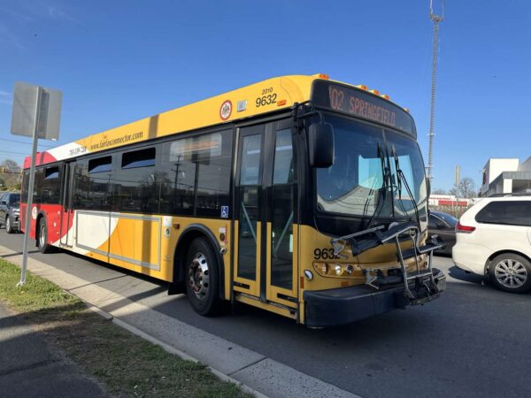
Fairfax Connector is shaking up its service along the I-66 corridor in anticipation of two major parking facilities finishing construction later this year.
The Fairfax County Department of Transportation has proposed adding or revising almost 30 routes in Tysons, Vienna, Springfield, Chantilly and Centreville, as it seeks to incorporate the upcoming Springfield and Monument Drive garages into its bus system.
According to FCDOT, the changes will improve travel throughout the D.C. region, with the Monument Commuter Parking Garage and Transit Center in particular supporting new connections between the eastern and western sides of the county.
“By creating a transfer point at the new Monument Park-and-Ride facility, riders will have the opportunity to transfer between local routes, access regional routes, and connect to the Vienna Metrorail Station, Franconia Metrorail Station, Tysons, or…D.C.,” FCDOT said in a news release.
Shaped by two previous rounds of public engagement, the proposed service plan will be presented today (Monday) at a 7 p.m. community meeting in the Franconia Government Center (6121 Franconia Road). Virtual meetings are also scheduled for 7 p.m. tomorrow (Tuesday) and Thursday (May 25).
The public can also provide input through an online survey until June 5.
Monument Drive
The $43 million Monument facility will boast 820 parking spaces, eight bus bays, a pick-up and drop-off area, and bicycle racks and storage. Located at the Government Center Parkway intersection next to Fairfax Corner, it broke ground in November 2021 as part of the I-66 widening.
FCDOT has proposed adding the facility as a stop on Route 660, a cross-county connector from the Stone Road Park & Ride in Centreville to the Tysons Metro station that launched in February.
Other notable changes involving the Monument facility include:
- Route 605: Reston Town Center Metro station to Fair Oaks Mall
- Route 622: Fairfax Towne Center circulator with more local links and new weekend service
- Route 625: New route to Random Hills Road and Pender Drive
- Route 651: New seven-day service to the Westfields, Chantilly, and Fair Ridge areas
- Route 663: Stringfellow Road Park and Ride to the Vienna Metro station
- Route 670: New peak express service between Chantilly and the Franconia-Springfield
Metro station - Route 671: New peak service from Chantilly to the Dunn Loring Metro station
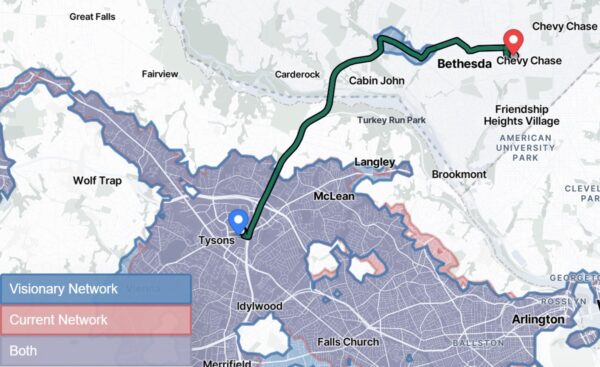
Local transportation officials are dreaming of a better future for Metrobus, including a 24-hour route connecting Tysons and Bethesda.
That route and others are part of Metro’s draft “Visionary Network,” an aspirational redesign of the 50-year-old bus network that will not be implemented — at least in full.
“It’s kind of setting the table large and saying what the opportunities are, and then constraining it,” said Allison Davis, vice president of planning at the Washington Metropolitan Area Transit Authority, at the Fairfax County Board of Supervisors transportation committee meeting Tuesday (May 16).
Other highlights for Fairfax County in the visionary plan include an extension of the 38B bus route to Seven Corners. Currently, the bus runs from Ballston to Farragut Square. There could also be added connections to George Mason University, a new hub for Inova Alexandria Hospital, and busing at Dulles International Airport when train service isn’t running.
At the meeting, both Davis and Peter Cafiero, managing director of intermodal planning at WMATA, highlighted interest in the Tysons-Bethesda route, which could be enabled by the Capital Beltway widening that’s now under construction.
“We’ve had a ton of comments about that Bethesda-to-Tysons connection that I think a lot of people are really keen to see,” Davis said.
After collecting feedback on the visionary network through this spring, WMATA will put together two network designs this fall. One will be a short-term network that’s immediately usable, while the other will be a revised version of the visionary network.
Changes could begin in 2024 if Metro’s board of directors approves the recommended short-term network in December.
WMATA is collaborating on the project with the Fairfax County Department of Transportation, which manages the Fairfax Connector bus system.
“We have been working with our partners at WMATA since the beginning of the process,” said Michael Felschow, planning section chief in the transit services division of FCDOT. “Our focus is to make sure our plans coordinate well with their plans.”
That coordination will involve making sure there are no gaps or duplications in service and helping to define service levels for prioritized routes, including on corridors such as Route 50, Braddock Road, Columbia Pike and Little River Turnpike.
“Our system doesn’t really provide a lot of service in these corridors, but we want to make sure we’re linking to these corridors at key terminals,” Felschow said.
Even as county staff works with WMATA, the county’s Transit Strategic Plan should remain “the driver” for FCDOT’s decision-making, Board of Supervisors Chairman Jeff McKay said. Cost efficiency should also be a “huge driver” in determining who operates different bus routes.
“I do think the vision of where these routes are and how we can make sure there’s no gaps in service and other things is absolutely an essential thing to do,” McKay said.
As currently outlined, the visionary network would require a 35% increase in funding for Metrobus. WMATA’s proposed budget for fiscal year 2024 allocates $742.9 million to Metrobus, a slight decrease from the $743.9 million budgeted in FY 2023.
The public comment period for the draft visionary network runs until June 5. Community members can weigh in on the network redesign ideas online and at pop-up events. The visionary network is part of the broader Better Bus initiative.
Map via WMATA
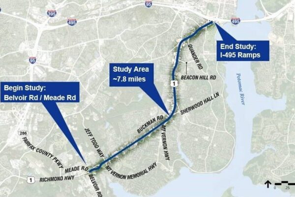
The speed limit on Richmond Highway (Route 1) has been permanently lowered through much of Fairfax County.
Starting next Tuesday (May 23), the legal limit will be reduced from 45 to 35 mph along a roughly 7-mile stretch between the Alexandria City limits at the Capital Beltway (I-495) and Jeff Todd Way/Mount Vernon Memorial Highway, the Virginia and Fairfax County transportation departments announced yesterday (Monday).
The departments said the change is designed “to optimize safety and operations for pedestrians, bicyclists, drivers and transit users” along a corridor that routinely sees devastating crashes.
Just this year, there have been at least 102 vehicle crashes on the Fairfax County section of Richmond Highway, injuring 75 people, according to state data. Prior to 2018, the total number of crashes consistently topped 400, peaking at 508 crashes in 2012.
So far in 2023, three people have been killed on the roadway: two pedestrians and a motorcyclist. Since 2011, there have been about 37 fatalities.
The Virginia Department of Transportation recommended in July 2022 that the speed limit be lowered after a year-long speed study found crashes occur more frequently on Richmond Highway than other primary highways in Northern Virginia, on average.
“The team also found that Richmond Highway between Buckman Road/Mount Vernon Highway and the Alexandria southern city limits had a higher incidence of pedestrian [and] bicycle crashes and speed-related crashes compared to other sections of Richmond Highway,” VDOT said.
However, the study recommended maintaining the existing 45-mph speed limit in the Fort Belvoir area from Belvoir Road to Jeff Todd Way. That 0.75-mile stretch had a lower crash rate, though about 50% of vehicles still exceed the speed limit, according to VDOT.
At a public meeting last summer, some community members raised concerns about the lower speed limit increasing congestion and questioned how effectively it’ll be enforced, but VDOT officials said the study indicated the change will have a “minimal” impact on traffic and allow tougher penalties on drivers who violate the limit.
Even a small decrease in vehicle speeds can lead to fewer serious crashes, according to the National Highway Traffic Safety Administration. A 5-mph reduction from 40 mph, for example, will produce an estimated 34% reduction in crashes with injuries.
Signs showing the new speed limit will be placed along Richmond Highway on May 23, VDOT said. A final report on the speed study is expected to be finished around the middle of this year.
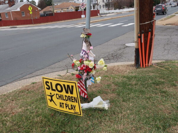
To the relief of Bailey’s Crossroads residents, some traffic safety improvements are in the works for the often harrowing area where Columbia Pike and Route 7 (Leesburg Pike) meet.
Perhaps the most urgent change will be the addition of a pedestrian hybrid beacon at the crosswalk across Columbia Pike at Tyler Street — the intersection where a driver hit and killed Justice High School student Lesly Diaz-Bonilla in November.
The Fairfax County Board of Supervisors approved an allocation of $920,000 to fund improvements at the intersection on April 11 as part of a $25 million slate of pedestrian safety projects planned throughout the county.
In the wake of Diaz-Bonilla’s death, over 1,000 residents signed an in-person and online petition calling for a reduction of the speed limit on Columbia Pike from 35 to 25 mph and other changes to the intersection, according to the Bailey’s Crossroads & Culmore Place-Based Initiative (PBI) Coalition, a community initiative led by George Mason University.
“This is a daily route to school for many children, including my own, and a route to work for many of us in Culmore,” resident Laura Doughty said in a press release from the coalition. “The lack of safety features for pedestrians coupled with the high-speed traffic makes it extremely dangerous for those of us who walk in the community everyday.”
Just 17 years old, Diaz-Bonilla had dropped off a younger sibling at a bus stop in front of the Barcroft View Apartments when a sedan crashed into her shortly before 9 a.m. on Nov. 16. After the crash, community members said they’d raised concerns about the intersection’s safety for years.
A report released last summer found that high vehicle speeds, incomplete sidewalks and limited crossings make Bailey’s Crossroads dangerous for pedestrians, particularly along the major corridors of Columbia Pike and Route 7.
A pedestrian hybrid beacon requires vehicles to stop if a pedestrian is present and pushes an activation button. A rapid flashing beacon with a pedestrian refuge island could be considered at the Tyler Street crosswalk instead if a hybrid beacon “is not feasible or warranted,” county staff said in a list of the safety projects that the board approved.
The April 11 vote also designated $1.9 million for a sidewalk on westbound Route 7 in front of the Liberty Gas station at 5930 Leesburg Pike in Culmore. A pedestrian was killed there in December 2021.
By press time, the Fairfax County Department of Transportation hadn’t returned a request for comment on when the projects will be implemented.
So far, the county has allocated about $30 million out of the $100 million that the Board of Supervisors pledged to spend on active transportation safety projects over six years, starting in 2022.
The inclusion of the Bailey’s Crossroads improvements in the latest package is the result of advocacy by residents, businesses, nonprofits and other organizations that have united around the need for safer streets, PBI Coalition program manager and Fairfax Families for Safe Streets Board of Directors member Katie Wilson said.
“The PBI Coalition will continue building these pipelines between local residents, organizations, and county leadership to amplify resident voices and ultimately work in partnership to build a community where all thrive,” Wilson said.
In a separate project, the county is planning to build a sidewalk and make other improvements in the Annandale section of Columbia Pike.
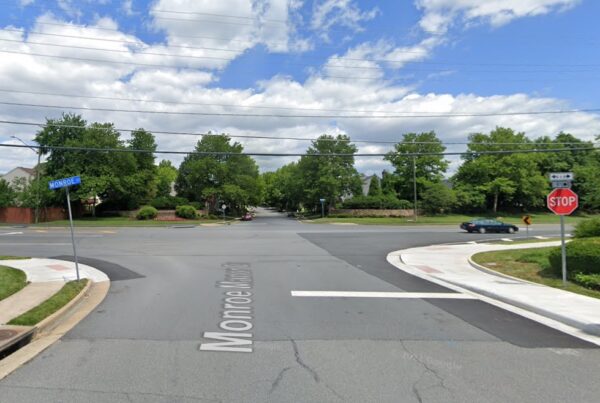
It’s repaving and restriping season once again, with public meetings coming later this month on proposed projects that would add bicycle lanes and improve crosswalks.
April marks the beginning of an annual process that ends in November with hundreds of miles of roadway being repaved and restriped by the Virginia Department of Transportation (VDOT).
In Fairfax County, more than 1,700 miles of roadway are expected to be repaved this year. The work often leads to new bike lanes, shoulders, crosswalks, signage, and street markings.
The program is “an opportunity to increase driver, bicyclist and pedestrian safety with road and crosswalk improvements while minimizing the financial investment in restriping work,” the Fairfax County Department of Transportation says on its website.
The first virtual public meeting hosted by VDOT and FCDOT will come on April 17 at 7 p.m. and cover proposals in the Hunter Mill and Providence districts.
One plan would add bicycle lanes on Glade Drive between Sunrise Valley Drive and Reston Parkway in Reston by narrowing the driver travel lanes.
In addition, upgrades are proposed at Monroe Street and Monroe Manor Drive in Herndon. This could include “marked crosswalks, high-visibility crosswalks and/or crosswalk signage,” the county says.
After a proposal for Ellenwood Drive was discussed at a separate meeting in February, the Providence District could get more bicycle lanes at four spots in the Merrifield and Annandale area:
- Executive Park Avenue between the Red Cross building and Prosperity Avenue
- Gatehouse Road between Telestar Court to Gallows Road and, potentially, Gallows Road to Williams Drive
- Williams Drive between Eskridge Road and Arlington Blvd and potentially between Arlington Blvd and Pennell Street
- Willow Oaks Corporate Drive between Williams Drive and Gallows Road
The lanes would be added by narrowing travel lanes or “repurposing underutilized parking lanes.”
Upgrades are also being considered for the intersection of Willow Oaks Corporate Drive and Professional Center Access Road in Merrifield. This could include marked crosswalks, high-visibility crosswalks, and additional signage.
Comments on projects in both districts will be accepted through the close of business on May 1.
Virtual public meetings will be held to discuss projects in Sully District on April 18, Franconia and Mount Vernon on April 19, Braddock and Mason on April 20, and Springfield on April 26.
Most of the proposed projects in those districts would also add bike lanes and improve crosswalks.
While all repaving and restriping work is set to begin soon and conclude by November, exact work dates for each project will be available “approximately ten days prior to work beginning.”
If the repaving requires parking to be limited, signs will be posted at least three business days in advance. Parked cars, basketball hoops, and garbage cans may need to be moved to accommodate the work.
In general, work hours will be limited to “outside of rush hours” with crews typically on-site in neighborhood streets on weekdays between 9 a.m. to 3 p.m. However, on interstates and some primary roads, work might happen overnight to limit the impact.
Residents should expect construction vehicles in their neighborhood during the project, and the county is asking motorists to “be alert to temporary traffic patterns.”
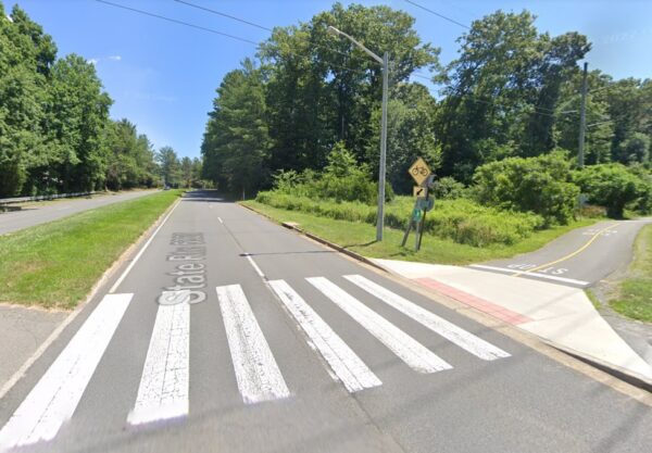
(Updated at 5:40 p.m.) Fairfax County transportation planners are considering the possibility of adding a traffic beacon to the intersection of Sunrise Valley Drive and the Washington & Old Dominion Trail (W&OD) near Robert Fulton Drive in Reston.
(Correction: This story previously said the beacon is being considered for the intersection of Sunrise Valley Drive and Wiehle Avenue.)
Robin Geiger, a spokesperson for the Fairfax County Department of Transportation (FCDOT) , said that the project is in the early phases of planning.
“There is no specific timeline but the team is continuing to prioritize projects over the new few months to be included in the remaining $70 million the Board of Supervisors approved for active transportation projects,” Geiger said.
The board has committed to spending $100 million on projects that improve road safety or accessibility for pedestrians, bicyclists and other non-motorized travelers.
One of thousands of projects that are being considered by the county, the Sunrise Valley and W&OD project could be considered for funding this fall. FCDOT is considering adding beacons to the area because of the “historically elevated rate of bike crashes, likely because the W&OD trail is a popular bicycle route,” Geiger said.
Changes would also need to be coordinated with NOVA Parks and the Virginia Department of Transportation.
Geiger said it is unclear what kind of signal would be installed.
Because of the speed limit, traffic volumes and lane configuration of Sunrise Valley Drive and the regional trail, a rectangular rapid-flashing beacon is not recommended based on state guidelines and national best practice, according to FCDOT.
County planners advise that a pedestrian hybrid beacon may be more appropriate, but more traffic analyses are required because of an adjacent signal at Robert Fulton Drive.
Last month, the county narrowed its list for $25 million of the pledged active transportation project funding. Planners combed through more than 2,000 possible projects to develop a draft list of priorities that’s set to be approved by the Board of Supervisors today (Tuesday).
Construction is currently underway on a pedestrian bridge for the W&OD Trail over Wiehle Avenue.
Photo via Google Maps

