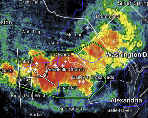
Email signup
Rain on brick walkway (staff photo by Angela Woolsey)

Rain, rain, it’s not going away just yet.

Another storm has emerged in the D.C. area, once again bringing the potential for flash flooding, according to the National Weather Service.

A Flash Flood Warning is in effect for southeastern Fairfax County, from Springfield to Mount Vernon and Lorton, until 7:30 p.m.

Excessive runoff may be particularly an issue in areas notably affected by thunderstorms yesterday (Monday) afternoon, when 2 to 4 inches of rain fell in the Springfield and Route 1 areas within the space of an hour.

“Doppler radar and automated rain gauges indicated thunderstorms producing heavy rain across the warned area,” the NWS said at 4:32 p.m. “Between 1 and 2 inches of rain have fallen. The expected rainfall rate is 1 to 3 inches in 1 hour. Additional rainfall amounts of 1 to 3 inches are possible in the warned area.”

In Fairfax County, yesterday’s storms mainly resulted in power outages, but they had a deadly impact in D.C., where rapidly rising waters killed 10 dogs at a local canine day care.

A Flood Watch has also been issued until 8 p.m.

The full alert is below.

* Flash Flood Warning for…Southeastern Fairfax County in northern Virginia…

* Until 730 PM EDT.

* At 432 PM EDT, Doppler radar and automated rain gauges indicated thunderstorms producing heavy rain across the warned area. Between 1 and 2 inches of rain have fallen. The expected rainfall rate is 1 to 3 inches in 1 hour. Additional rainfall amounts of 1 to 3 inches are possible in the warned area. Flash flooding is ongoing or expected to begin shortly.
HAZARD…Flash flooding caused by thunderstorms.
SOURCE…Radar and automated gauges.
IMPACT…Flash flooding of small creeks and streams, urban areas, highways, streets and underpasses as well as other poor drainage and low-lying areas.

* Some locations that will experience flash flooding include…

Alexandria… Springfield…Fort Hunt… Groveton…Huntington… Fort Belvoir…Burke… Lincolnia…Lorton… Franconia…Hybla Valley… Newington…I395 and I495 Interchange…West Springfield…Mount Vernon… North Springfield…Hayfield… Mason Neck…Jefferson Manor…

FLASH FLOOD…RADAR AND GAUGE INDICATED EXPECTED RAINFALL RATE…1-3 INCHES IN 1 HOUR

0 Comments
Power outages in Belle Haven on Aug. 14, 2023 (via Dominion Energy)

Nearly 9,000 people in Fairfax County are without power after this afternoon’s storms, the most intense of which have moved on into Maryland.

As of 5:30 p.m., 8,971 Dominion Energy customers in the county had lost power, according to the real-time tracking database PowerOutage.US.

The most sizable outages have cropped up in Belle Haven along the Route 1 corridor, where 3,429 customers have lost power, and near Kingstowne along Beulah Street in Franconia, where 1,895 customers are affected, according to Dominion Energy’s outage map.

Per the map, Dominion has confirmed that the Franconia outage was caused by the storm, which produced high-speed winds that  prompted a Tornado Warning from 4:18-4:33 p.m. Crews are currently working on the incident, potentially restoring power between 5 and 10 p.m.

Causes for the most significant outages in the Belle Haven area are still pending investigation, but crews are now assessing the damage, according to Dominion. The estimated time of restoration ranges from 6 p.m. to midnight.

Power outages have also been reported in West Springfield and Mantua.

While there hasn’t been any confirmation of tornadoes, wind gusts reached 58 mph at Reagan National Airport, according to the Capital Weather Gang.

A Flash Flood Warning remains in effect until 7:45 p.m. Some flooding was reported in Springfield and the Alexandria area, where 2 to 4 inches of rain had fallen as of 5 p.m., the National Weather Service said.

0 Comments
A storm has reached Fairfax County, as seen on radar around 4 p.m. on Aug. 14, 2023

Updated at 4:45 p.m.The Tornado Warning was terminated early at 4:33 p.m., but Severe Thunderstorm and Flash Flood warnings remain in effect until around 5 p.m. and 7:45 p.m., respectively.

Updated at 4:25 p.m.A Tornado Warning has also been issued until 4:45 p.m.

“At 418 PM EDT, a severe thunderstorm capable of producing a tornado was located over Franconia, or over Springfield, moving northeast at 25 mph,” the National Weather Service said.

Updated at 4:20 p.m. — The Flash Flood Warning has been expanded to include the Tysons area, Vienna and Annandale.

Earlier: This afternoon’s rush-hour commute will be a wet one.

A thunderstorm has reached Fairfax County, and it could bring some flooding, according to the National Weather Service.

The agency has issued a Flash Flood Warning specifically for the southern half of the county and the Fairfax City area. The alert will be in effect until 8 p.m.

“Turn around, don’t drown when encountering flooded roads,” the NWS said. “Most flood deaths occur in vehicles. Basement flooding can occur quickly and create a life-threatening situation. If you are in a basement, or a residence below street level, move to a higher floor immediately.”

A Severe Thunderstorm Warning is also in effect until 4:30 p.m., affecting the Fort Belvoir, Mount Vernon and Lorton areas.

According to the NWS, radar showed “a severe thunderstorm” moving northeast at 20 mph from Quantico at 4:02 p.m. Wind gusts of up to 60 mph are possible.

“Damaging winds will cause some trees and large branches to fall,” the agency warns. “This could injure those outdoors, as well as damage homes and vehicles. Roadways may become blocked by downed trees. Localized power outages are possible. Unsecured light objects may become projectiles.”

The full Flash Flood Warning is below:

* Flash Flood Warning for…Southern Fairfax County in northern Virginia…Prince William County in northern Virginia…The City of Fairfax in northern Virginia…

* Until 800 PM EDT.

* At 353 PM EDT, Doppler radar indicated thunderstorms producing heavy rain developing across the warned area. Additional rainfall amounts of 1 to 3 inches are possible in the warned area. Flash
flooding is expected to begin shortly.

HAZARD…Flash flooding caused by thunderstorms.
SOURCE…Radar.
IMPACT…Flash flooding of small creeks and streams, urban areas, highways, streets and underpasses as well as other poor drainage and low-lying areas.

* Some locations that will experience flash flooding include…
Centreville…Dale City… Annandale…Springfield… Fairfax…Fort Hunt… Groveton…Huntington… Mantua…Fort Belvoir… Woodbridge…Quantico… Lake Ridge…Burke… Oakton…Lincolnia… Montclair…
Lorton… Franconia…

This includes the following Flood Prone Roads:
Woodburn Road at Accotink Creek…Fairfax Boulevard at Oak Street…Fairfax Boulevard at University Drive…Pickett Rd at Accotink Creek near Old Pickett Rd… Mine Road and Cameron Street…

0 Comments
A rain storm passes over central Fairfax (via NWS)

Rain is pouring down on Fairfax County, raising the risk of flooding.

The National Weather Service has issued a Flash Flood Warning for the central portion of the county, including Oakton, Annandale, Merrifield and Fairfax City.

In effect until 6:30 p.m., the warning anticipates up to 3 inches of rain in the affected areas. As of 3:25 p.m., between half-an-inch and 1.5 inches had already fallen.

“Turn around, don’t drown when encountering flooded roads,” the NWS said. “Most flood deaths occur in vehicles. Basement flooding can occur quickly and create a life-threatening situation. If you are in a basement, or a residence below street level, move to a higher floor immediately.”

The full flood warning is below:

* Flash Flood Warning for…
Western Arlington County in northern Virginia…
Central Fairfax County in northern Virginia…
The Northwestern City of Alexandria in northern Virginia…
The City of Fairfax in northern Virginia…
The City of Falls Church in northern Virginia…

* Until 630 PM EDT.

* At 325 PM EDT, Doppler radar indicated thunderstorms producing heavy rain across the warned area. Between 0.5 and 1.5 inches of rain have fallen. Additional rainfall amounts of 1 to 3 inches are possible in the warned area. Flash flooding is ongoing or expected to begin shortly.

HAZARD…Flash flooding caused by thunderstorms.
SOURCE…Radar.
IMPACT…Flash flooding of small creeks and streams, urban areas, highways, streets and underpasses as well as other poor drainage and low-lying areas.

Updated at 4:30 p.m. — According to Fairfax Alerts, high water has closed Prosperity Avenue at Morningside Drive in the Mantua area.

As of 4:20 p.m., 926 Dominion Energy customers had lost electricity, according to the utility’s outage map.

The largest outages are in Springfield north of the Mixing Bowl, where 547 people are without power and the estimated time of restoration is 5-10 p.m. Another 147 customers have been affected by outages in Lincolnia, where power is expected to return between 7 p.m. and midnight.

Updated at 4:55 p.m. — Woodburn Road at Spicewood Drive has also closed as a result of high water, per Fairfax Alerts. The closure is located just south of Accotink Creek.

Updated at 6:25 p.m. — A Flood Warning has now been issued, extending to 9 p.m. The NWS says 1-4 inches of rain have fallen so far in the central Fairfax area, along with Alexandria, Arlington and Falls Church.

“Flooding of rivers, creeks, streams, and other low-lying and flood-prone locations is imminent or occurring,” the NWS said. “Streams continue to rise due to excess runoff from earlier rainfall.”

0 Comments
A power outage is affecting Pimmit Hills on Aug. 10, 2022 (via Dominion Energy)

An ongoing thunderstorm has taken out power for hundreds of Fairfax County residents, as the threat of flash flooding looms.

The National Weather Service has issued a Flash Flood Warning for the D.C. region that is set to remain in effect until 8 p.m.

According to the alert, between 1.5 and 2.5 inches of rain have fallen so far, and an additional 1 to 2 inches are possible. Areas of concern include Reston, Centreville, Annandale, Vienna, Falls Church, McLean, Great Falls, Chantilly, and Fairfax Station.

More than a thousand Dominion Energy customers have been affected by power outages since rain arrived in the area this afternoon, according to the utility company’s outage map.

The largest impact appears to be in Pimmit Hills, where 647 customers are without power. An outage affecting 328 people near Eagle View Elementary School in the Fairfax area is expected to be addressed between 6 and 11 p.m.

In the Herndon area, an outage at the Herndon Parkway and Sterling Road intersection has affected 221 customers. Dominion estimates that power will be restored there between 7 p.m. and midnight.

Herndon Parkway has been closed in both directions at Palmer Drive after an accident, according to the Town of Herndon Police Department. Power lines are down there.

The full Flash Flood Warning from the NWS is below: Read More

0 Comments
Raindrops in puddles (staff photo by Jay Westcott)

After a stormy night, more rain is on the way this afternoon (Friday), prompting the National Weather Service to issue a Flood Watch for Fairfax County and the rest of the D.C. region.

The alert will take effect at 3 p.m. and is currently set to continue until 11 p.m.

“Flash flooding caused by excessive rainfall is possible,” the alert says, projecting possible, localized rainfall totals of 2 to 4 inches.

The full alert from the NWS is below:

…FLOOD WATCH IN EFFECT FROM 3 PM EDT THIS AFTERNOON THROUGH THIS
EVENING…

* WHAT…Flash flooding caused by excessive rainfall is possible.

* WHERE…DC and portions of Maryland and Virginia, including the following areas: the District of Columbia. In Maryland, Anne Arundel, Calvert, Carroll, Central and Southeast Howard, Central
and Southeast Montgomery, Charles, Frederick MD, Northern Baltimore, Northwest Harford, Northwest Howard, Northwest Montgomery, Prince Georges, Southeast Harford, Southern Baltimore and St. Marys. In Virginia, Albemarle, Arlington/Falls Church/Alexandria, Culpeper, Eastern Loudoun, Fairfax, Greene, King George, Madison, Nelson, Northern Fauquier, Orange, Prince William/Manassas/Manassas Park, Rappahannock, Southern Fauquier, Spotsylvania, Stafford and Western Loudoun.

* WHEN…From 3 PM EDT this afternoon through this evening.

* IMPACTS…Excessive runoff may result in flooding of rivers, creeks, streams, and other low-lying and flood-prone locations.

* ADDITIONAL DETAILS…
– Showers and thunderstorms will develop this afternoon and may last into the evening. Any thunderstorms will be capable of producing very heavy rainfall, with localized totals of two to four inches possible. Much of the rain may fall within a one to three hour period, making rapid rises in creeks and streams possible, as well as flash flooding in urban areas.

0 Comments
The National Weather Service issued a Severe Thunderstorm Watch in the area through 10 p.m. (via National Weather Service)

Fairfax County and areas nearby are under a Severe Thunderstorm Watch this evening.

The National Weather Service issued a Flood Watch earlier today (Monday), cautioning flooding may occur this evening, and a Severe Thunderstorm Watch is in effect until 10 p.m.

“Excessive runoff may result in flooding of rivers, creeks, streams, and other low-lying and flood-prone locations,” the Flood Watch reads. “Afternoon to evening showers and thunderstorms may produce very heavy rainfall capable of flash flooding. This could include multiple rounds of storms which would enhance the flood risk. Rainfall rates may reach 1 to 2 inches per hour, locally higher in spots. The D.C. and Baltimore metros will be the most susceptible given recent heavy rainfall the past couple of weeks.”

The National Weather Service advises residents to monitor forecasts and be prepared in case of flash floods.

0 Comments
Lightning (via Breno Machado/Unsplash)

Fairfax County is under a Severe Thunderstorm Watch and Flood Watch as storms are expected in the region this evening.

The National Weather Service issued the watches this afternoon. They both expire at 10 p.m.

Rainfall could cause flash flooding in the area, according to the Flood Watch.

“Strong to severe thunderstorms will move across the region late this afternoon through the evening hours,” the Flood Watch says. “Heavy rain will accompany a number of these storms which may drop 1 to 2 inches of rainfall in an hour.”

A Hazardous Weather Outlook for the area also says the primary threats are wind gusts and large hail, with the possibility of an isolated tornado.

The full Flood Watch is below.

Event: Flood Watch
Alert:
…FLOOD WATCH REMAINS IN EFFECT UNTIL MIDNIGHT EDT TONIGHT…

* WHAT…Flash flooding caused by excessive rainfall continues to be possible.

* WHERE…Portions of DC, Maryland and northern Virginia, including the following areas: in DC, District of Columbia. In Maryland, Anne Arundel, Calvert, Central and Southeast Howard, Central and Southeast Montgomery, Charles, Northern Baltimore, Northwest Howard, Northwest Montgomery, Prince Georges, Southern Baltimore and St. Marys. In northern Virginia, Arlington/Falls Church/Alexandria, Fairfax, King George, Prince William/Manassas/Manassas Park and Stafford.

* WHEN…Until Midnight EDT tonight.

* IMPACTS…Excessive runoff may result in flooding of rivers, creeks, streams, and other low-lying and flood-prone locations. Creeks and streams may rise out of their banks.

* ADDITIONAL DETAILS…
– Strong to severe thunderstorms will move across the region late this afternoon through the evening hours. Heavy rain will accompany a number of these storms which may drop 1 to 2
inches of rainfall in an hour. Additionally, some regions could see repeat thunderstorm activity leading to an enhanced threat for flooding.
– http://www.weather.gov/safety/flood
Instructions: You should monitor later forecasts and be prepared to take action should Flash Flood Warnings be issued.

Photo via Breno Machado/Unsplash

0 Comments
Flooding on Old Courthouse Road in Vienna (file photo)

Fairfax County is under a Flood Watch until midnight.

The National Weather Service issued the watch this morning, noting flash flooding caused by excessive rainfall is possible after 3 p.m.

Showers and thunderstorms are expected later this afternoon into the evening, according to the National Weather Service. There will be heavy rainfall at times, with predicted rainfall amounts of 1 to 3 inches within the span of a couple of hours, according to the Flood Watch.

A Hazardous Weather Outlook in the county states damaging winds and hail are also possible.

Showers and thunderstorms are likely, mainly between 3 PM and 11
PM. A Flash Flood Watch for potential flash flooding is in effect
near and west of Interstate 95 during this time. Isolated
instances of flooding can`t be ruled out further east.

In addition, a few storms may become severe with damaging wind
gusts and large hail. An isolated tornado can`t be ruled out.

0 Comments
Raindrops in puddles (staff photo by Jay Westcott)

The rain now passing through Fairfax County could lead to flash flooding this afternoon and evening (Thursday).

The National Weather Service has issued a Flood Watch for much of the D.C. area that’s currently set to be in effect until 8 p.m.

Here is more from the alert:

* IMPACTS…Excessive runoff may result in flooding of rivers, creeks, streams, and other low-lying and flood-prone locations. Flooding may occur in poor drainage and urban areas.

* ADDITIONAL DETAILS…
– A strong surface trough has settled over the I 95 corridor and has become the focus for the formation of strong thunderstorms. PWs greater than 1.7 inches combined with the potential for training storms capable of producing 2 to 3 inches per hour may lead to an increased threat for flash flooding over the more urban areas along the I-95 corridor. One to two inches of rain are likely within training storms with locally higher amounts around 4 inches are possible.

The region is also under a Severe Thunderstorm Watch until 9 p.m.

0 Comments
×

Subscribe to our mailing list