(Updated at 3:45 p.m.) A years-long effort to build a pedestrian and bicycle trail along Fairfax Blvd (Route 50) is facing a roadblock.
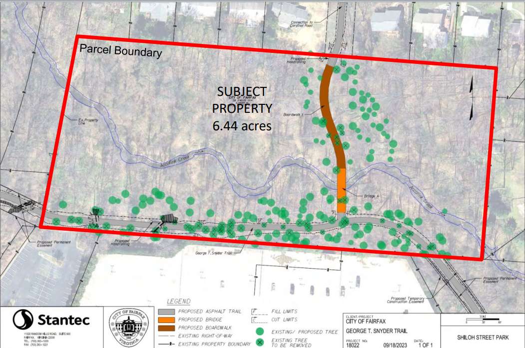
At a public hearing last Tuesday (Sept. 26), the Fairfax City Council deferred action on a special use permit for nearly 12,000 square feet of trail in Shiloh Street Park (10400 Shiloh Street). The affected area requires the permit because it is zoned for residential development.
The Shiloh Street Park passageway, which would include asphalt pavement, a boardwalk and a bridge over the Accotink Creek, would join the partially-constructed George Snyder Trail. Plans for the Snyder trail have been in the works for more than a decade.
Per a July presentation from city staff, the final version of the trail will be 1.78 miles long and offer a route for pedestrians and cyclists parallel to Fairfax Blvd from Chain Bridge Road (Route 123) to Draper Drive, connecting to the Wilcoxon Park trail.
The special use permit request for Shiloh Street Park now appears on the agenda for the council’s Oct. 10 meeting, where it will not require a public hearing. The vote to defer action was unanimous.
Councilmember D. Thomas Ross said he supported the deferral to give the council time to gather additional information and reflect on concerns raised by community members.
Councilmember Kate Doyle Feingold said the proposal was developed to use funding, rather than to serve residents.
Much of the Snyder trail’s $18.8 million estimated cost will be covered by money from the state’s I-66 Outside the Beltway project, which funds 16 projects approved by the Commonwealth Transportation Board with the recommendation of the Northern Virginia Transportation Authority.
“What we need to do is design things that the community and residents want, design things that protect our natural spaces, that make our residents feel safe and comfortable, places people love to go, like Daniels Run Trail,” Doyle Feingold said.
Among other concerns, she said the project would “take down an unnecessary hundreds of trees”
City staff estimate the Shiloh Street Park portion of the project would require removing 59 trees, while the overall project would require removing 568 trees — a prospect that has fueled opposition to the trail from some community members.
A mitigation plan to offset the prospective tree losses would plant 858 trees and 815 shrubs — all native species — in the project area, including 518 trees and 353 shrubs in the resource protection area, a city spokesperson says.
During the public hearing, four individuals who said they live in the Mosby Woods neighborhood near Shiloh Street Park spoke against having an access point to the trail near their homes, citing crime.
Ross said he recognized those concerns, and the city is taking action to address them. Ultimately, though, he remained supportive of the trail.
“From a trail perspective, and from our parks and our open space, opening them up to public access can be a good thing. It adds visibility. It adds public use,” he said.
Ross also said there has been “strong community support” for the trail over the years of its development.
The Fairfax Alliance for Better Bicycling called on riders to support trail construction ahead of a city council work session in July.
The vote on the Shiloh Street Park special use permit is not the last action the city council will take on the trail project this year. If the permit is approved, the body will vote this winter to award a contract for construction, which is scheduled for spring 2024, per city staff’s July presentation.

A rabid skunk was found on the Bull Run Occoquan Trail on Saturday, June 10, the Fairfax County Health Department confirmed today (Tuesday).
The skunk reportedly chased, sprayed and bit multiple hikers before it was found near Balmoral Terrace and Cannon Fort Drive in Clifton. Health officials advise that it may have had contact with other people or pets during the time that it was sick.
The skunk was described as an adult largely black animal with a large white stripe covering most of its back. It was reported several times between 7 a.m. and 2 p.m. before it was captured by Animal Protection Police.
Rabies can infect wildlife — especially foxes, raccoons, skunk, bats and domestic animals. People get rabies when they are bitten or scratched by an animal infected by it.
To date, 10 animals have been diagnosed with rabies in the county this year, including a raccoon that was bitten by a dog in Vienna last month.
Here’s more from the health department on what to look out for:
Animals with rabies may act normally during the early stages of the disease, making it difficult to know if the animal is infected. As the disease progresses, animals often show changes in behavior. For example, wild animals may act very docile and domestic animals may become aggressive. Rabid animals may stagger, drool, or become paralyzed. Protect yourself and your family from rabies: stay away from wild animals and be sure pets are vaccinated against rabies every year. Remember, if the animal is not your own, leave it alone!
If bitten or scratched by an animal that might have rabies, wash the wound thoroughly with soap and water and seek medical attention right away. When vaccinations are provided in time and appropriately, rabies treatment is 100 percent effective in preventing the disease. But if not treated, rabies is 100 percent fatal.
If anyone was bitten or scratched by the animal on or around June 10, county health officials urge individuals to call the Fairfax County Health Department Rabies Program at 703-246-2433, extension 711.
Photo via Bryan Padron/Unsplash
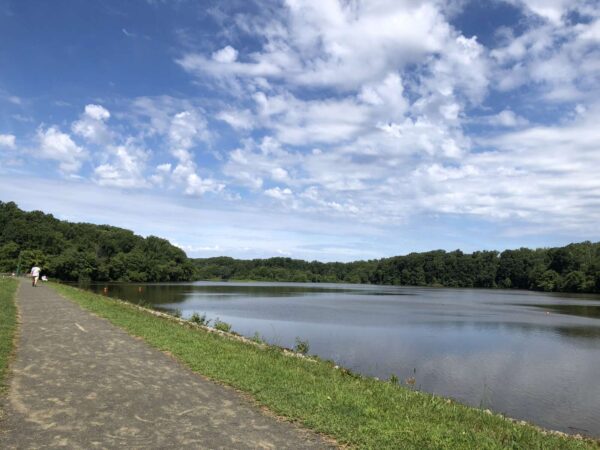
Questions continue to swirl around Lake Accotink Park’s long-term future, but that hasn’t stopped Fairfax County from pursuing some needed facility upgrades.
This Saturday (June 3), the Fairfax County Park Authority will celebrate the completion of its new Accotink Creek Crossing, a 320-foot-long concrete trail and 325-foot, elevated pedestrian bridge that closes 3.9-mile trail loop around the North Springfield park.
Coinciding with National Trails Day, the ribbon-cutting ceremony at 8:30 a.m. will be followed by a full day of outdoor activities, including nature and history hikes and a trail bicycle ride.
Under construction since last summer, the new crossing has improved the conditions and slope of the trail at the Lake Accotink dam outfall, according to the park authority.
“The previous stream crossing at the outfall of the Lake Accotink dam was subject to sudden and frequent flooding, often stranding trail users and tempting them to wade through swiftly moving water,” the authority said. “Additionally, excessive storm damage necessitated the total reconstruction of the trail twice within the last five years.”
The project was funded with just over $3 million from park bonds.
Playground replacement expected this year
Other impending improvements include an overhaul of the park’s playground, which has been out of commission since November after an inspector determined that the aging equipment was unsafe to use.
With $300,000 approved for a replacement, the park authority recently unveiled a design concept showcasing the features planned for the new playground, including a tower structure with a slide, four swings, a climbing net, a bouldering feature, a music feature, and a playhouse.

“In the interest of delivering a functional, safe and enjoyable playground experience as quickly as possible, this particular project was conducted as an in-kind replacement,” meaning it will fit within the footprint of the existing playground, FCPA spokesperson Benjamin Boxer said.
The new equipment is expected to be installed late this summer or by early fall, though the timeline could be revised “as ordering, delivery and installation details are finalized,” according to Boxer.
As the county develops a vision for the park’s future, which might not include a lake, the park authority says it intends to recommend adding a second, larger playground. Read More
A connection has now been solidified between Herndon Metro station and Van Buren Street.
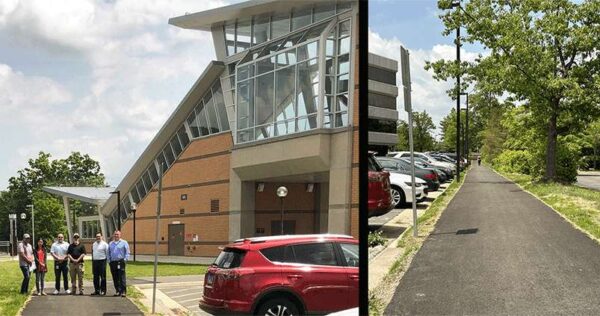
The Town of Herndon has completed construction of an 800-foot trail for pedestrians and bicyclists that connects the Metro station to Van Buren Street by Worldgate Centre.
“The 800-foot trail provides ready access to Metro for workers in the Worldgate and nearby office complexes,” the Town of Herndon said.
The trail goes live as Bike to Work Day kicks off on Friday (May 19). The Herndon area will have pit stops at the Innovation Center Metro station and the Town Hall Green.
Construction on the project began in September 2022. The project was completed roughly two months ahead of schedule, according to town spokesperson Anne Curtis.
The overall project cost $600,000 for design and construction. It was funded through a combination of town funds as well as funds from Fairfax County’s Herndon Metrorail Station Access Management Study.
The trail was officially opened last week, not long after construction finished on nearby improvements along Van Buren Street from Spring Street to Herndon Parkway. That “complete streets” project widened the road, added curb-and-gutter and bicycle lanes, and made some intersection and stormwater upgrades.
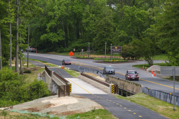
Fairfax County leaders will hold a ribbon-cutting ceremony and an inaugural bicycle ride and walk tomorrow (Friday) to celebrate the completion of the Mount Vernon Memorial Highway Trail.
Mount Vernon District Supervisor Dan Storck will join the Fairfax County Department of Transportation and the Department of Public Works and Environmental Services at George Washington’s Gristmill to mark the finishing of the trail.
The purpose of the project was to complete missing trail segments between Richmond Highway (Route 1) and Southwood Drive, a span of approximately two miles.
The project completes the missing links for the:
- East Coast Greenway Trail
- Potomac Heritage National Scenic Trail
- NoVa Loop Trail
Storck told FFXnow he has been pushing to get the project completed to connect more of the county’s Potomac Banks tourism sites and to provide new transportation and recreation options for residents.
“This new shared-use path now provides a continuous pedestrian and bicycle way from Richmond Highway to George Washington’s Mount Vernon Estate, then north to the City of Alexandria and the District of Columbia,” Storck said. “It will also provide connections to the future ‘The One’ Bus Rapid Transit System.”
The project constructed a 6,400-foot-long, 10-foot-wide shared-use path, which includes a pedestrian bridge adjacent to the Mount Vernon Memorial Highway bridge crossing Dogue Creek.
“The Potomac Heritage National Scenic Trail will provide a continuous facility for pedestrians and cyclists along Mount Vernon Memorial Highway from Route 1 to the Mount Vernon Estates,” the county website states.
The project also provided marked crosswalks and curb ramps compliant with Americans with Disabilities Act (ADA) regulations and standards to improve pedestrian crossings.
The county incorporated comments from a 2018 pedestrian safety public information meeting into the design plans.
“As an avid runner and cyclist, one of my priorities as supervisor has been pedestrian and bicycle safety, and completing missing trail and sidewalk connections,” Storck said.
The locally funded project cost approximately $6.5 million. The ceremony will start at 10 a.m.
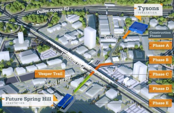
(Updated at 12:15 a.m. on 4/27/2023) Preliminary construction activities will kick into gear this weekend on a long-gestating project to move part of an electric transmission line underground in the Spring Hill area of Tysons.
Starting this Friday (April 28) evening, Dominion Energy will close the Vesper Trail from Route 7 (Leesburg Pike) to Vesper Street so its crews can install a manhole needed for the project, spokesperson Peggy Fox said. The trail closure will last until Tuesday (May 2).
“This closure is necessary to keep community members safe while we install a manhole,” Fox told FFXnow.
Replacing an existing above-ground line, the new 230-kilovolt transmission line will span approximately half a mile from Dominion’s Tyco Road substation to the vicinity of a planned Spring Hill substation just southwest of Leesburg Pike and Spring Hill Road.
An underground line will be safer and less visually obtrusive, while helping Tysons meet the demand for electricity as the area continues to develop, Dominion has said. Removal of the existing overhead line will also “facilitate” construction on The View, a mixed-use development planned next to the Spring Hill Metro station, according to documents filed with the State Corporation Commission.
The project was endorsed by the Fairfax County Board of Supervisors in March 2020 and approved by the SCC on June 24, 2021.
Dominion notified residents in the area on April 14 that construction on the power line would begin this month, noting that the county has waived noise restrictions for the project until Oct. 31 since some work will occur at night.
“To limit traffic impacts on major roadways, particularly Leesburg Pike, construction will be performed at night,” the utility company said. “This allows our crews to obtain necessary lane closures to complete the work safely and efficiently.”
Split into five phases, the project includes the installation of two manholes, which will occur throughout the day and night so they can be completed “as expeditiously as possible.”
“There will be more impacts to the trail in fall 2023 when we begin installing the underground line in this area, and outreach will take place prior,” Fox said by email. “No impacts to electric service are anticipated as a result of this work.”
Including the addition of a transition pole at the end of the new line and removal of the old overhead line, the project is expected to finish in late 2024. At that point, Dominion says it will begin construction on the Spring Hill substation, which will occupy a 1-acre site near Raglan Road Park.
The new substation will support customers south of Route 7 (Leesburg Pike) and outside of I-495, according to Dominion.
The Tysons Community Circuit is finally starting to take shape in concept, if not in reality quite yet.
The Fairfax County Board of Supervisors accepted new design guidelines last Tuesday (Feb. 7) for the 4.75-mile recreational trail that will one day loop around the core of Tysons, assuming everything goes according to the county’s comprehensive plan.
While the trail only exists on paper right now, an initial segment will be delivered as part of The Boro’s expansion, which commenced construction in early 2022.
“We have the first portion coming in with the next piece of The Boro, so I think this is going to be an exciting opportunity for beautiful and multi-use opportunities in the Tysons area,” Providence District Supervisor Dalia Palchik said.
Crafted by county staff and developer representatives from the Tysons Partnership (now evolving into the Tysons Community Alliance), the design guidance outlines the overall vision for the Tysons Community Circuit and sets standards for paving, crosswalks, signs and other elements.
Dated Dec. 6, 2022, the document calls for consistency throughout the trail, proposing concrete as the primary pavement material to “unify the diverse building frontages and site conditions” in the area.
It also stresses the need for a “comprehensive approach” to intersections and crosswalks that considers both pedestrians and non-motorized vehicles like bicycles. Accent strips and “artistically designed” crosswalks with bold colors are recommended as visual cues.
“Accent strips should be incorporated at intersection approaches to alert users of potential conflict points,” the guidance says. “The changes in both color and texture will alert pedestrians to slow down as they approach intersections.”
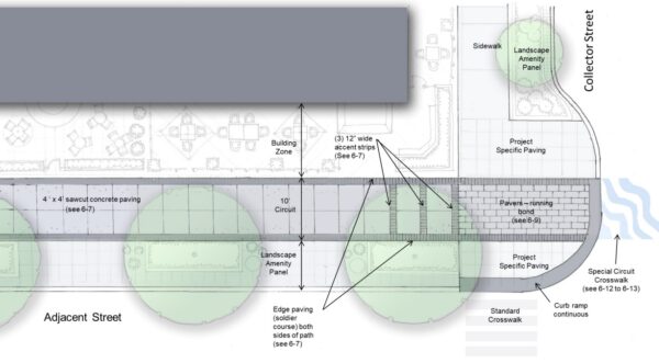
Crosswalk design will be particularly important when the circuit crosses major roads — especially the Capital Beltway (I-495), Leesburg Pike (Route 7) and Chain Bridge Road (Route 123) — and when it switches to the opposite side of the street, according to the document.
The guidance also has examples of amenities for the trail, like benches, trash receptacles and bicycle and scooter parking racks. It recommends incorporating “colorful decals and pavement markings” to reinforce the Tysons brand and create a sense of place.
Decals and pavement markings can also:
- Provide directional information
- Mark travel distances
- Supply event information
- Celebrate the seasons
- Transmit safety messages
- Spread knowledge of history, literature, the arts, nature, science, etc.
Now that it has the board’s endorsement, the guidance will be used during reviews of development applications, according to a county staff report.
Along with the three-block segment in The Boro expansion, the Fairfax County Planning Commission approved a development plan for a residential building at The Mile in May that includes a 7,595-square-foot portion of the community circuit.
“The guidance is intended as a working document, and subject to refinement to reflect changing development conditions along the Circuit to ensure the best outcomes for the Circuit as a recreational trail and placemaking element in Tysons,” county staff said. “In locations where redevelopment is not anticipated, segments of the Circuit could be constructed with public funds, grants, or through public-private partnerships.”
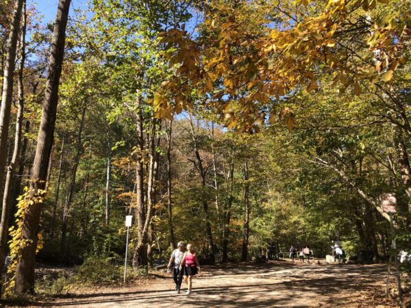
Fairfax County’s trails are ready for their close-up.
With 2023 right around the corner, the Fairfax County Park Authority and Fairfax County Park Foundation are once again inviting community members to take a hike and submit their best snapshots for potential prizes.
The annual First Hike Fairfax photo contest will return this weekend, encouraging both professional and amateaur photographers to capture the scene at any park authority-owned trail.
“The contest joins countless First Day Hike programs throughout America’s state parks and is open to hikers and photographers of any age and skill level,” the FCPA said in a news release. “It’s a great way of getting out and enjoying the new year with friends, neighbors and family.”
A link for submissions will go live on the contest website at 5 a.m. Saturday (Dec. 31) and close right at midnight on Monday (Dec. 2).
Prizes will be given in seven categories:
- People’s Choice: $100 Park Authority Gift Card or 25-visit FCPA Rec Center Discount Fast Pass (valued at $175)
- Judges’ Choice: $100 Park Authority Gift Card or 25-visit FCPA Rec Center Discount Fast Pass (valued at $175)
- Director’s Choice: $100 Park Authority Gift Card
- Best in Show (Scenery/Landscapes): $75 Park Authority Gift Card
- Best in Show (People): $75 Park Authority Gift Card
- Best in Show (Wildlife): $75 Park Authority Gift Card
- Best in Show (Pets): $75 Park Authority Gift Card
Each person can only submit one photo, though families or groups can send in individual submissions. Photos must be provided as a JPG or PNG, and they should include a date and the park or trail where they were taken, according to the FCPA.
The park authority oversees over 334 miles of trails, not including regional facilities like the Washington & Old Dominion Trail.
Close to 600 racers gathered at Lake Fairfax Park in Reston over the weekend to raise money for the park’s trails.
The annual event, called 2022 Capital Cross Classic, took place on Sunday (Dec. 4) at the park, which is located at 1400 Lake Fairfax Drive.
The Bike Lane, a Reston-based business, took over the race more than 10 years ago, according to Todd Mader, co-owner of the business.
Money raised from the fund is specifically used to restore multi-use trails that surround the parking, Mader said.
“We won’t know the final figure until we see how much grass was ruined and how much we need to reseed, but this was a good year so at least $4,000,” Mader wrote in a statement to FFXnow.
The event is a USA Cycling cyclocross event. It will benefit the Lake Fairfax Sustainable Natural Trail System. Races were divided by time and for different ages.
The Bike Lane is a family-owned bicycle shop that has locations in Reston and Springfield.
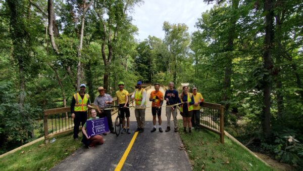
The National Park Service has completed the first of four planned projects to reconstruct bridges along Mount Vernon Trail.
Park service staff, elected officials and community members celebrated the reopening of Bridge 12 near Fort Hunt Park with a ribbon-cutting ceremony on Saturday (Sept. 24). The occasion coincided with National Public Lands Day, which encourages volunteers to help restore and improve national parks and other public lands.
“The Mount Vernon Trail is a very popular recreational resource and these bridge improvements will greatly increase safety for thousands of trail users,” said Charles Cuvelier, superintendent of the George Washington Memorial Parkway, which runs parallel to the 18-mile trail.
Mount Vernon District Supervisor Dan Storck and state Sen. Scott Surovell were among the officials who attended the ribbon-cutting.
A beautiful morning celebrating the reopening of Bridge 12 with the Friends of the Mount Vernon Trail and @ssurovell, Superintendent Charles Cuvelier and Judd Isbell! And, spreading the word about Tour de Mount Vernon! https://t.co/eTrftrB44N pic.twitter.com/iQ6Ufp0kbu
— Supervisor Dan Storck (@DanStorck) September 24, 2022
Exciting ribbon cutting today on the new $3M 14-foot wide bridge on the Mt. Vernon Trail near Ft. Hunt Park – taller, wider, straighter & safer! @NPSNewsDC @vabike @betterDCregion @Karen4Schools pic.twitter.com/ptTdCa4dq8
— Senator Scott Surovell (@ssurovell) September 24, 2022
The reconstruction began on Feb. 14 and involved relocating Bridge 12, expanding it to 14 feet in width, installing upgraded railings, and resurfacing the trail to the bridge from Waynewood Blvd to Fort Hunt Road, according to the NPS.
The straighter alignment and reduced slope of the trail leading to and from the bridge enabled by its new location will improve safety, the park service said in its news release.
According to On the MoVe, the previous bridge was “known for frequent bike mishaps” and had been under consideration for an overhaul for decades before getting the needed funding from the Virginia Department of Transportation in 2018. The Federal Highway Administration also assisted.
First opened on April 15, 1972, the Mount Vernon Trail spans over 18 miles from George Washington’s Mount Vernon to Theodore Roosevelt Island near Arlington. Maintained with help from the volunteer nonprofit Friends of the Mount Vernon Trail, the facility reached its 50th anniversary earlier this year.
NPS’ next reconstructions for the southern end of the trail will focus on Bridges 23 and 24 between Belle Haven Road and Tulane Drive, On the MoVe reported. The park service plans to replace four bridges in all over the next five years.

