A floodwall in the Belle Haven community could help address Northern Virginia’s flood risk.
A recent study looked at the west bank of the Potomac River from Arlington to Prince William County for solutions to improve resiliency and reduce risks to human health and safety, economic damages, and disruption of critical infrastructure, according to a presentation.
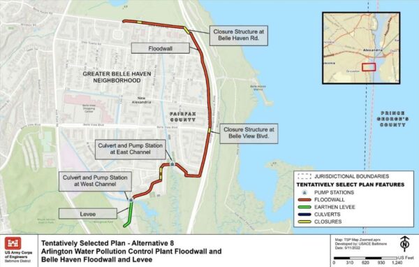
While there were multiple options, the U.S. Army Corps of Engineers found a 5,600-foot-long floodwall in Belle Haven and a 2,500-foot-long floodwall along the Arlington Water Pollution Control Plant on S. Glebe Road were the most feasible.
The total cost of both would be $52.6 million, which includes a 45% contingency on costs, and is estimated to reduce about $66 million in potential damage.
The proposed Belle Haven floodwall would begin around Golf Course Square and extend down Boulevard View before turning west. Then, an earthen levee would be constructed and end near Westview Dog Park, according to the Feasibility Report and Environmental Assessment by Army Corps of Engineers, Baltimore District, and the Metropolitan Washington Council of Governments.

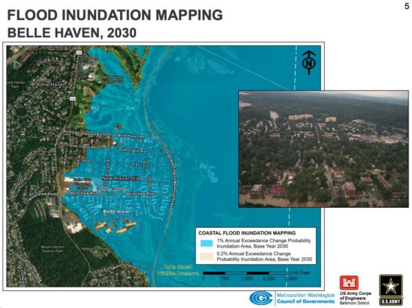
A map of Belle Haven shows that by 2030, the flood risk could extend to the Belle View Shopping Center, Belle Haven Country Club and other parts of the community.
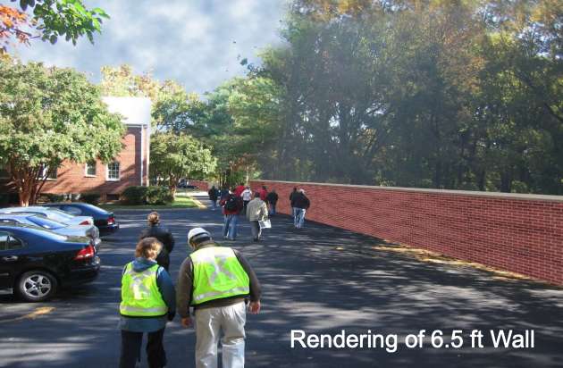
The Belle Haven floodwall would have permanent aesthetic and recreation impacts, as well as stream impacts, according to the presentation. The floodwall would be about 6 feet tall on average.
During construction, there would also be temporary stream impacts. Mitigation would be required for permanent stream impacts.

The public can comment on the study through Thursday, June 30, by emailing the project team at DC-Metro-CSRM-Study@usace.army.mil. The Corps of Engineers will respond to comments and revise the report between July and September, determing if this is the preferred option by November.
After further study, design — which hasn’t been funded yet — wouldn’t begin on the project until at least 2024.
The study was conducted as Northern Virginia has seen damaging storms over the years, to include the Chesapeake and Potomac Hurricane of 1933, Hurricane Agnes (1972), Hurricane Fran (1996), Nor’easter (1998), Hurricane Floyd (1999), Hurricane Isabel (2003), Hurricane Irene (2011) and Hurricane Sandy (2012).
Hurricane Isabel resulted in extreme water levels and caused millions of dollars of damage to residences, businesses and critical infrastructure, according to the study.
Recent Stories

Unlike our competitors, Well-Paid Maids doesn’t clean your home with harsh chemicals. Instead, we handpick cleaning products rated “safest” by the Environmental Working Group, the leading rating organization regarding product safety.
The reason is threefold.
First, using safe cleaning products ensures toxic chemicals won’t leak into waterways or harm wildlife if disposed of improperly.

There’s a reason Well-Paid Maids has hundreds of positive reviews from happy clients in the D.C. area.
The home cleaning company pays cleaners — who are W-2 employees — a living wage starting at $24 an hour. Plus, cleaners are offered benefits, including insurance, 24 paid days off a year, 100% employer-paid commuting costs and more.
Lexi Grant, an operations manager at Well-Paid Maids, said it best: “People deserve their work to be respected and recognized. When that happens, you love what you do, and you create the best results.”
Dream, Design, Build: Home Expo 2024
Sponsored by ABW Appliances & Eden, join us for a one-of-a-kind Home Expo event on May 11th from 10AM to 4PM!
The DMV’s top experts — AKG Design Studio and GMJ Construction — are opening their doors to homeowners to
Ravel Dance Company presents The Sleeping Beauty at Capital One…
Be transported to the magical kingdom of Princess Aurora, where the wicked Carabosse casts a curse that dooms the Princess and her entire kingdom. Set to the spectacular Tchaikovsky score, this beloved classic will sweep you away with its beauty,


