Trees, steep hills, pedestrian paths, building heights, and townhomes were the most talked-about elements during last week’s discussion about the redevelopment of the Huntington Transit Station Area.
At the Oct. 19 Planning Commission meeting, commissioners and the public weighed in with their thoughts and concerns on the proposed revamp of the Huntington Transit Station Area (TSA).
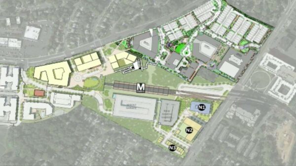
The staff’s comprehensive plan amendment calls for mixed-use development including 382,000 square feet of office, retail, and community-use space, the possibility of a hotel with conference facilities, and 1,500 residential units. 15% of those units at “minimum” should be affordable, the report notes.
A bus rapid transit station is also being called for with a “large, publicly accessible civic plaza” above the station. Plus, more urban park space and “a network of high-quality pedestrian and bicycle paths” connecting to the transit stations and other amenities are also being recommended.
To make room for the redevelopment, it’s being asked that the northern parking garage be torn down.
While a decision was delayed until Nov. 16 on if to approve the comprehensive plan, a lengthy discussion ensued at last week’s meeting. The conversation included the commissioners, county staff, the Mount Vernon Site-Specific Plan Amendment (SSPA) Task Force, Washington Metropolitan Area Transit Authority (WMATA), and the public.
The discussion focused prominently on the site’s challenging topography, the possible addition of townhomes on the northeastern side of the project, preserving a tree buffer, the potentially costly addition of one particular pedestrian path, and building heights.
There are a number of engineering challenges associated with the project mostly due to the Huntington Metro station being located on a steep hill.
“The most significant and defining feature of this site is the grade, from north to south. The highest point of the site is in the southern end on N. Kings Highway and it’s approximately 160 above sea level,” said Graham Owen from the county’s Dept. of Planning and Development. “In contrast, the lowest point of the site is on the northern portion along Huntington Ave and that’s at approximately 30 feet above sea level. So, there are about 130 feet of grade change along the site.”
This extra layer requires adaptation, both in terms of engineering and user experience, particularly when it comes to the building of roads, pedestrian pathways, and buildings.
“That is a hill like you’ve never seen…if you want to work out, run up and down North Kings Highway,” Franconia District Commissioner Dan Lagana noted with a laugh in midst of a discussion about how best to build paths for pedestrians.
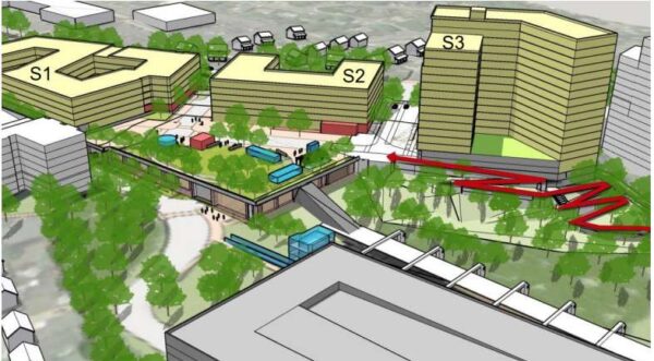
This challenge also relates to building height. If buildings on the southern end of the site are allowed to go up to the maximum allowable height of 200 feet, they could look a lot taller to those seeing the buildings from the north. This was a point of concern for several residents that spoke during the public hearing portion.
“I’d like them to really think about the height of a [200-foot] building. We can already see the parking garage over the tops of the trees,” said one resident. “If they are going to put something that’s two or three times taller than what’s already there, we will have a loss of complete privacy. I’m not opposed to development, but I don’t think that’s great development for people who have bought homes [there].”
Also, in the northeastern portion of the site, there’s currently a tract of trees that has become the subject of perhaps the most significant disagreement about the comprehensive plan.
The tract of trees near the intersection of Huntington Ave and Biscayne Drive acts as essentially a buffer between the townhomes along Biscayne Drive and the Metro station. It’s also where WMATA has proposed selling the land to a developer to build more townhomes.
Steven Segerlin, WMATA’s director of real estate and station area planning, noted that the major barriers to this project – at least from WMATA’s perspective – are financial.
“Based on initial estimates, construction costs… will be significantly greater than the revenue generated by the private developers that could possibly help pay for them,” he said.
Because of this, WMATA wants to sell the land where the trees are to developers for the building of townhomes. Both the staff report and the Mount Vernon SSPA Task Force proposed keeping the trees.
“Giving the high cost for public infrastructure needed to address the area’s lack of connectivity, the Huntington Metro site needs to generate as much revenue as possible to help pay for them,” said Segerlin. “The loss of the townhome development potential significantly reduces that revenue potential and will increase the gap funding request to the county, state, and federal government.”
He further noted that not only does Metro not have the funds to make up this gap, but the agency’s “policy does not allow it.”
Ellen Young of the Mount Vernon SSPA Task Force expressed surprise at this WMATA request. She noted, along with several residents and staff, how the trees are an important buffer between the homes already there and the Metro station. In addition, they are needed to help ease stormwater concerns in a part of the county that does have flooding.
“We had all agreed to the fact that the trees were going to stay there. And that agreement included WMATA,” said Young. “So, I think we were all caught a little off guard tonight.”
Also, a subject of concern from WMATA was a certain pedestrian path that would lead from the condo community Huntington Club to the southern portion of the development. The agency asked it not to be a “requirement” for the entire plan to move forward.
Between dealing with the steep hill and the need to potentially also build also through a grove of trees, the expense could end up being great noted Segerlin. Both staff and the task force appeared to agree that the one path was likely to be more difficult to develop and seemed open to moving forward without it.
Overall, there was considerable agreement on the goals of the comprehensive plan, which is to redevelop the area near the Huntington Metro station to make it denser, more accessible, safer, more inviting, and full of amenities available to the entire Huntington community.
“Development in this area will enhance the character of the community, increase patronage for existing local businesses and lead to reinvestment in the surrounding neighborhoods,” reads the staff report. “The area will become a place where county residents can live, work and shop without excessive dependence upon the automobile, thus realizing some of the county’s key policy objectives.”
Recent Stories

Unlike our competitors, Well-Paid Maids doesn’t clean your home with harsh chemicals. Instead, we handpick cleaning products rated “safest” by the Environmental Working Group, the leading rating organization regarding product safety.
The reason is threefold.
First, using safe cleaning products ensures toxic chemicals won’t leak into waterways or harm wildlife if disposed of improperly.

There’s a reason Well-Paid Maids has hundreds of positive reviews from happy clients in the D.C. area.
The home cleaning company pays cleaners — who are W-2 employees — a living wage starting at $24 an hour. Plus, cleaners are offered benefits, including insurance, 24 paid days off a year, 100% employer-paid commuting costs and more.
Lexi Grant, an operations manager at Well-Paid Maids, said it best: “People deserve their work to be respected and recognized. When that happens, you love what you do, and you create the best results.”
Dream, Design, Build: Home Expo 2024
Sponsored by ABW Appliances & Eden, join us for a one-of-a-kind Home Expo event on May 11th from 10AM to 4PM!
The DMV’s top experts — AKG Design Studio and GMJ Construction — are opening their doors to homeowners to
Ravel Dance Company presents The Sleeping Beauty at Capital One…
Be transported to the magical kingdom of Princess Aurora, where the wicked Carabosse casts a curse that dooms the Princess and her entire kingdom. Set to the spectacular Tchaikovsky score, this beloved classic will sweep you away with its beauty,


