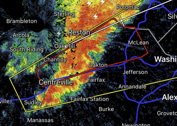
Email signup
Lightning (via Breno Machado/Unsplash)

Updated at 6:50 p.m. — The Severe Thunderstorm Watch was canceled at 6:41 p.m., according to a National Weather Service alert.

Earlier: Fairfax County is under a Severe Thunderstorm Watch, and part of the county is also under a Severe Thunderstorm Warning.

The county is under a severe thunderstorm watch until midnight, according to the National Weather Service. There’s also a severe thunderstorm warning for west central Fairfax County, including Burke and Chantilly, until 6:15 p.m.

“Damaging winds will cause some trees and large branches to fall,” the warning reads. “This could injure those outdoors, as well as damage homes and vehicles. Roadways may become blocked by downed trees. Localized power outages are possible. Unsecured light objects may become projectiles.”

The watch was issued at 5:11 p.m. Ready Fairfax said to expect damaging winds and large hail. Isolated tornadoes are possible.

The full watch is below.

Event:
Severe Thunderstorm Watch
Alert:
SEVERE THUNDERSTORM WATCH 378 REMAINS VALID UNTIL MIDNIGHT EDT
TONIGHT FOR THE FOLLOWING AREAS
IN VIRGINIA THIS WATCH INCLUDES 22 COUNTIES
IN CENTRAL VIRGINIA
ALBEMARLE CITY OF CHARLOTTESVILLE
CITY OF FREDERICKSBURG GREENE
KING GEORGE NELSON ORANGE
SPOTSYLVANIA
IN NORTHERN VIRGINIA
ARLINGTON CITY OF ALEXANDRIA CITY OF FAIRFAX
CITY OF FALLS CHURCH CITY OF MANASSAS
CITY OF MANASSAS PARK CULPEPER
FAIRFAX FAUQUIER LOUDOUN
PRINCE WILLIAM STAFFORD
IN NORTHWEST VIRGINIA
MADISON RAPPAHANNOCK
THIS INCLUDES THE CITIES OF ALEXANDRIA, ARLINGTON, CHANTILLY,
CHARLOTTESVILLE, CROZET, CULPEPER, DAHLGREN, FAIRFAX,
FALLS CHURCH, FALMOUTH, FREDERICKSBURG, GORDONSVILLE, GREENFIELD,
HERNDON, LEESBURG, MADISON, MANASSAS, MANASSAS PARK, MCLEAN,
ORANGE, RESTON, SPOTSYLVANIA COURTHOUSE, STANARDSVILLE, STERLING,
WARRENTON, WASHINGTON, AND WOODBRIDGE.
Instructions:

Target Area:
Albemarle
Arlington
City of Alexandria
City of Charlottesville
City of Fairfax
City of Falls Church
City of Fredericksburg
City of Manassas
City of Manassas Park
Culpeper
Fairfax
Fauquier
Greene
King George
Loudoun
Madison
Nelson
Orange
Prince William
Rappahannock
Spotsylvania
Stafford

Photo via Breno Machado/Unsplash

0 Comments
Power outages following Monday’s thunderstorm are concentrated along the Route 1 corridor (via Dominion Energy)

(Updated at 6:30 p.m.) The thunderstorm has passed, but it has left some destruction in its wake, taking out electricity for more than 8,000 people in Fairfax County.

According to PowerOutage.US, there are currently 8,707 customers without power in the county.

The worst damage is in the Groveton and Hybla Valley area along Route 1, where around 5,835 Dominion Energy customers are currently without power, according to the utility company’s outage map.

Outages have also affected over 500 customers in Springfield.

The outages come after a thunderstorm hit the D.C. area earlier this afternoon (Monday), prompting reports of quarter-sized hail.

The National Weather Service issued a Severe Thunderstorm Warning for Fairfax County until 4:45 p.m.:

HAZARD…70 mph wind gusts and half dollar size hail.

SOURCE…Radar indicated.

IMPACT…Damaging winds will cause some trees and large branches to fall. This could injure those outdoors, as well as damage homes and vehicles. Roadways may become blocked by
downed trees. Localized power outages are possible. Unsecured light objects may become projectiles.

* Locations impacted include… Arlington, Alexandria, Centreville, Waldorf, Dale City, Annandale, Clinton, Springfield, Fort Washington, Fairfax, Fort Hunt, Vienna, Groveton, Falls Church, Huntington, Coral Hills, Mantua, Fort Belvoir, Woodbridge and National Harbor.

NWS urges residents to move to an interior room on the lowest floor of a building.

A Severe Thunderstorm Watch was also issued for the county. It was expected to last until 9 p.m., but got canceled shortly before 5:30 p.m. after the storm moved on.

Angela Woolsey contributed to this report.

0 Comments

Update at 9:15 p.m. — The earlier Tornado Warning, and one issued subsequently, have both been cancelled. It appears that a rotating storm — possibly a weak tornado — passed by Tysons Corner Center mall, according to video posted on social media. There are also reports of damage near the Tysons Corner Metro station.

Note that the video below contains strong language.

Earlier: Parts of Fairfax County are under a Tornado Warning.

Take cover if you’re in the path of the potential tornado, including parts of Oakton, Vienna, Tysons, Falls Church or McLean.

From the National Weather Service:

BULLETIN – EAS ACTIVATION REQUESTED
Tornado Warning
National Weather Service Baltimore MD/Washington DC
822 PM EDT Thu Mar 31 2022

The National Weather Service in Sterling Virginia has issued a

* Tornado Warning for… Northern Fairfax County in northern Virginia…

* Until 845 PM EDT.

* At 821 PM EDT, a severe thunderstorm capable of producing a tornado was located over Chantilly, or over Centreville, moving northeast at 35 mph.

HAZARD…Tornado.

SOURCE…Radar indicated rotation.

IMPACT…For those in the direct path of a tornado touchdown, flying debris will be dangerous to those caught without shelter. Damage to roofs, siding, and windows may occur. Mobile homes may be damaged or destroyed. Tree damage is likely.

* This dangerous storm will be near… Reston, Vienna and Oakton around 840 PM EDT. Pimmit Hills, American Legion Bridge, Mclean, Tysons Corner and Wolf Trap around 845 PM EDT.

Other locations impacted by this tornadic thunderstorm include Dunn Loring, Belleview and West Mclean.

PRECAUTIONARY/PREPAREDNESS ACTIONS…

TAKE COVER NOW! Move to a basement or an interior room on the lowest floor of a sturdy building. Avoid windows. If you are outdoors, in a mobile home, or in a vehicle, move to the closest substantial shelter and protect yourself from flying debris.

Via social media:


0 Comments

Waters from the Potomac River could spill over into Fairfax County, with the D.C. area expected to get almost nonstop rain tomorrow (Friday), the National Weather Service warns.

A Coastal Flood Warning will be in place for Northern Virginia, including Fairfax County, starting at 6 p.m. today (Thursday) until 8 a.m. Saturday (Oct. 30).

According to the NWS, showers and thunderstorms from the Midwest are moving east and could bring 1 to 2 inches of rain, along with the risk of flash flooding along the Potomac River and Chesapeake Bay.

Here is more from the NWS alert:

…COASTAL FLOOD WARNING NOW IN EFFECT FROM 6 PM THIS EVENING TO 8 AM EDT SATURDAY…

* WHAT…Two to four feet of inundation above ground level possible in low lying areas.

* WHERE…Prince William/Manassas/Manassas Park, Fairfax and Stafford Counties.

* WHEN…From 6 PM this evening to 8 AM EDT Saturday, especially around the time of high tide.

* IMPACTS…Numerous roads may be closed. Low lying property including homes, businesses, and some critical infrastructure will be inundated. Some shoreline erosion will occur.

The NWS has also issued a Flood Watch that will be in effect from 10 a.m. to 6 p.m. tomorrow, with rainfall potentially reaching 2 to 4 inches in some areas.

“Heavy amounts of rain will cause creeks and streams to slowly rise, possibly out of their banks as well as the potential for flooding in urban areas,” the NWS said.

The Fairfax County Office of Emergency Management says the risk of rain will likely arrive in the county around midnight to 2 a.m. Friday, echoing the Fire and Rescue Department’s warning that flooding may lead to road closures.

“Low lying property, including homes, businesses and some critical infrastructure, may be inundated,” OEM said in a blog post. “Take the necessary actions to protect flood-prone property. If travel is required, do not drive around barricades or through water of unknown depth.”

The office also advised keeping children away from creeks or other bodies of water that may rise rapidly, and clearing leaves and other debris from downspouts and storm drains.

0 Comments
×

Subscribe to our mailing list