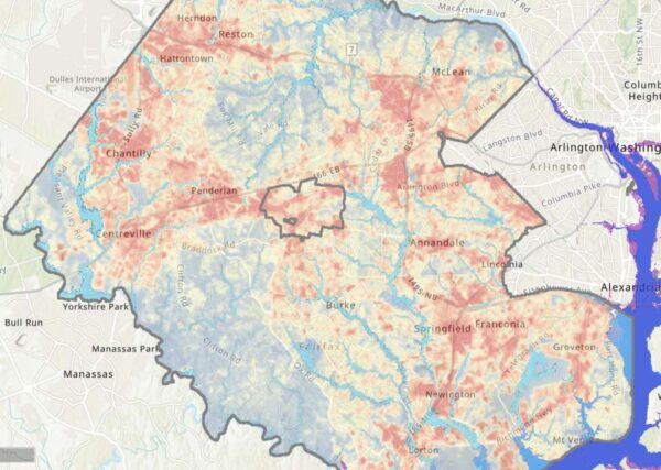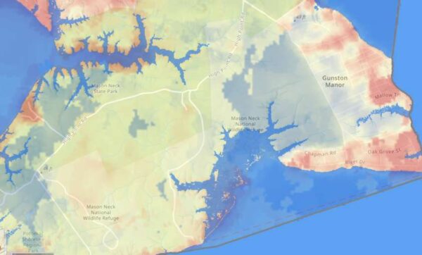
As Fairfax County finalizes its first-ever plan to address the future effects of climate change, community members can see how the phenomenon already affects them with a newly released interactive map.
Launched last week, the climate map depicts heat and flooding data that can be viewed in conjunction with maps of the county’s population and infrastructure, including roads, utilities, and public facilities.
“The Fairfax County interactive climate map is a dynamic tool showcasing some of the best available data we have to date on climate impacts in our community,” Matt Meyers, the climate planning division director for the Fairfax County Office of Environmental and Energy Coordination, said. “The map is meant to inform and empower county residents, business owners, and community leaders to actively prepare for and participate in resilience efforts on a local level.”
The map offers a clear illustration of the heat island effect, showing that average daytime temperatures are higher in more populated and developed areas along major highways, like Tysons, Reston, the Fair Lakes and Fair Oaks area, and the Route 1 corridor.
Flooding appears to be most intense in the southeast part of the county, with waters from the Potomac River and Occoquan Bay overflowing onto Belle Haven, Lorton, Mason Neck, and Fort Belvoir. If sea levels rise a foot, Mason Neck will noticeably shrink. If they rise three feet, the Route 1 ramps to I-495 at the Alexandria border will be submerged.

The OEEC developed the map using information gathered through its Resilient Fairfax initiative, which started last year to establish a Climate Adaptation and Resilience Plan intended to reduce and prepare the county for the damages that will come with a rapidly warming Earth.
So far, the initiative has produced:
- A Climate Projections Report, which found that rising greenhouse gas emissions could fuel a significant increase in days with temperatures over 95 degrees
- An audit analyzing how well the county’s existing policies and facilities take climate change into account
- A draft Climate Vulnerability and Risk Assessment, which looked at which residents, services, and facilities are most vulnerable to the impacts of climate change
- A draft Climate Adaptation and Resilience Plan that recommended creating a fund for climate-related county projects, among other proposals
The Climate Adaptation and Resilience Plan will be finalized and presented to the Board of Supervisors for acceptance this fall, according to OEEC spokesperson Ali Althen.
The climate map uses the same data that went into the projections report and risk assessment, but it’s narrower in scope, focusing on current flood and heat information with some indicators of future conditions, such as “projected sea level rise and coastal storm surge,” the OEEC says.
With marginalized communities facing the most severe consequences from climate change, the map also incorporates data from the county’s Vulnerability Index, which scored different areas based on residents’ income, education, homeownership, and other socioeconomic factors.
The OEEC says it’s important for residents to understand what climate hazards are in store for the county so they can get involved in efforts to address those impacts. In Belle Haven, for instance, the U.S. Army Corps of Engineers has already proposed building a wall to mitigate flooding.
“Awareness is the first step toward climate readiness, and we hope this tool will allow users to grow in their understanding of the risks facing Fairfax County now and in the years to come,” Meyers said.
Recent Stories

Unlike our competitors, Well-Paid Maids doesn’t clean your home with harsh chemicals. Instead, we handpick cleaning products rated “safest” by the Environmental Working Group, the leading rating organization regarding product safety.
The reason is threefold.
First, using safe cleaning products ensures toxic chemicals won’t leak into waterways or harm wildlife if disposed of improperly.

There’s a reason Well-Paid Maids has hundreds of positive reviews from happy clients in the D.C. area.
The home cleaning company pays cleaners — who are W-2 employees — a living wage starting at $24 an hour. Plus, cleaners are offered benefits, including insurance, 24 paid days off a year, 100% employer-paid commuting costs and more.
Lexi Grant, an operations manager at Well-Paid Maids, said it best: “People deserve their work to be respected and recognized. When that happens, you love what you do, and you create the best results.”
Dream, Design, Build: Home Expo 2024
Sponsored by ABW Appliances & Eden, join us for a one-of-a-kind Home Expo event on May 11th from 10AM to 4PM!
The DMV’s top experts — AKG Design Studio and GMJ Construction — are opening their doors to homeowners to
Ravel Dance Company presents The Sleeping Beauty at Capital One…
Be transported to the magical kingdom of Princess Aurora, where the wicked Carabosse casts a curse that dooms the Princess and her entire kingdom. Set to the spectacular Tchaikovsky score, this beloved classic will sweep you away with its beauty,


