

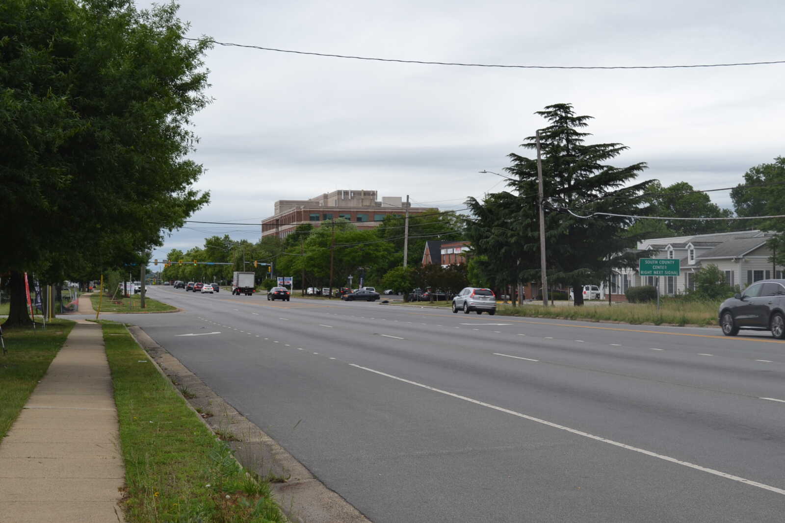
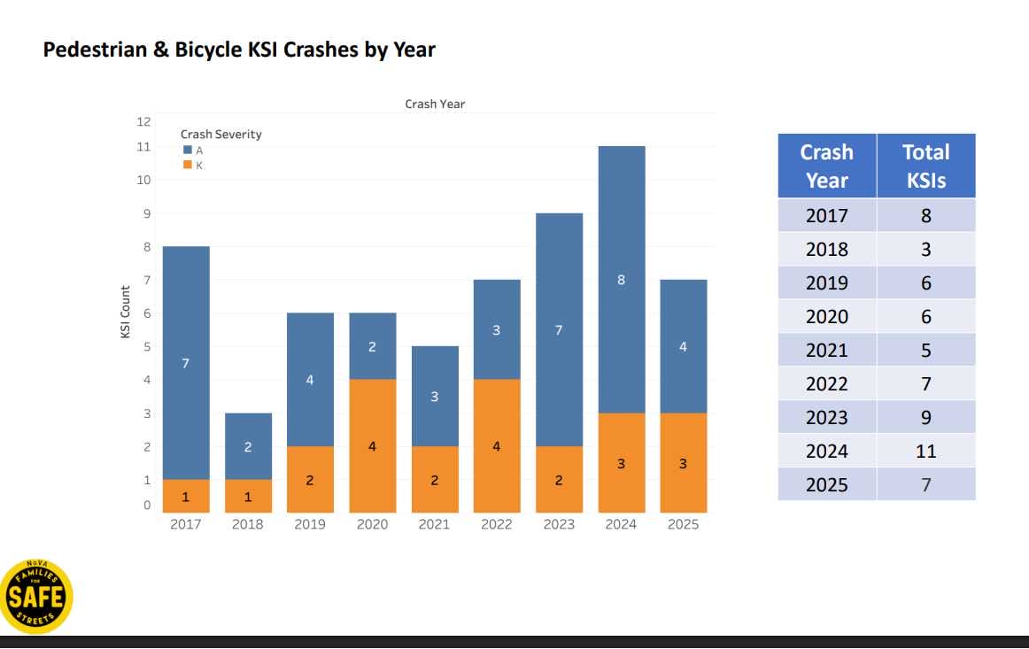
More than 60 pedestrians and cyclists have been killed or seriously injured in crashes on Richmond Highway over the past decade — and conditions appear to be worsening instead of improving, a new analysis says.
Skimpy lighting and crossings, along with alcohol intoxication, appear to be driving factors behind the frequent serious crashes that occur in the approximately 14-mile corridor from the Alexandria border down to the Occoquan River south of Lorton, according to Northern Virginia Families for Safe Streets (NoVA FSS).
“The Richmond Highway corridor is a concentrated and consistent pedestrian safety crisis,” the volunteer-led advocacy group said. “These crashes are not randomly distributed — they cluster in predictable locations shaped by inadequate lighting, incomplete crosswalk infrastructure, alcohol exposure, and high pedestrian activity among vulnerable populations.”
Released this morning (Thursday), the report compiled by NoVA FSS with the help of college students specializing in data analysis identified and evaluated 62 fatal or serious-injury crashes involving pedestrians and bicyclists that were reported in the Richmond Highway corridor from 2017 through 2025.
Two more pedestrians have been killed in crashes on Richmond Highway so far this year. Both involved alcohol, though speed and distracted driving were also tagged as contributing factors in the earlier Jan. 7 crash, according to Virginia Department of Transportation data.
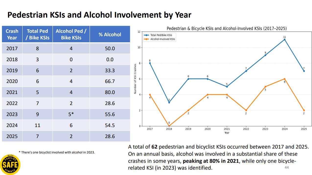
During the study period of 2017-2025, alcohol was a factor in 47% of all fatal and serious-injury crashes on Richmond Highway, including 41% of all fatalities. The prevalence of alcohol has increased post-Covid, jumping from 35% of crashes to 51% since 2020, NoVA FSS reported.
The Huntington Avenue intersection emerged as a hotspot, with alcohol involved in four of five crashes there, as did the Pohick/Backlick Road intersection. The analysis noted the proximity of those sites to a Virginia ABC store, motels and the Eleanor U. Kennedy Shelter.
“An in-depth social scientific study is recommended to better determine the cause & effect of these factors,” NoVA FSS said, suggesting that Fairfax County could “deploy street safety and alcohol awareness programs” to those locations if deemed appropriate.
The dominant risk factor identified by the analysis, however, was nighttime conditions, which were in place for 77% of the reviewed crashes and 95% of fatalities, according to the Richmond Highway analysis.
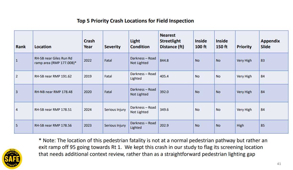
Thirty-three of the 62 crashes (53.2%) occurred when the sun was down on parts of the road with lighting, while 15 were in unlit areas. About two-thirds of the crashes were located within 100 feet of a streetlight, but at five crash sites identified as priorities for review, the closest streetlight was still at least 200 feet away, the report says.
Based on the severity of crashes and a lack of overhead streetlights, the study recommends prioritizing inspections of the lighting conditions at southbound Route 1 near the Giles Run Road exit ramp from I-95 in Lorton, a cluster near the Master Pro Truck Services driveway north of Giles Run, and southbound Richmond Highway just south of the I-495 interchange in Huntington.
Three locations were the sites of crashes that killed pedestrians, and all of them are outside of intersections, where lighting tends to be more limited. State and county officials should install upgraded streetlights within 150 feet of all five locations, prioritizing the three spots where there were fatal crashes, NoVA FSS recommends.
“Existing street lighting is insufficient,” the analysis said. “Over half of all crashes — and half of fatalities — occurred on lighted roads, pointing to visibility gaps, inadequate light levels, and pedestrian detection failures.”
The review also found gaps in the availability of crosswalks, with 65% of all the studied crashes and 82% of those with fatalities occurring outside a marked crosswalk or intersection.
While there’s a temptation to fault the pedestrian for not using a crosswalk, the analysis notes that the median distance of the crashes from the nearest sidewalk is 209 feet. Nineteen of 21 gaps between designated crossings in the corridor exceed the recommended 600 feet, with the longest between North Kings Highway and Southgate Drive reaching nearly half a mile or 2,600 feet.
Despite their proximity to bus stops, the three intersections with the most crashes — Backlick/Pohick, Huntington Avenue and Lockheed Blvd — all have at least one leg with no crosswalk, requiring people to cross two or three times to reach the other side.
The study also considered the role of vehicle speeds in pedestrian and cyclist-involved crashes. While speed was identified as a factor in only five (8%) of the 62 crashes in VDOT’s data, it accounted for three of 22 fatalities, and it’s likely “under-reported” since the corridor doesn’t have any cameras or other devices consistently tracking speeds, NoVA FSS says.
Mike Doyle, executive director of the nonprofit, says the group wanted to take a closer look at Richmond Highway in Fairfax County because it’s rated by VDOT as one of the most dangerous roads in Virginia for pedestrians, and the corridor is home to many neighborhoods defined as “vulnerable” by the county based on income, education, English-speaking proficiency and other factors.
A senior county policymaker also asked NoVA FSS — whose efforts to advocate for pedestrian and bicyclist safety include collecting data on near-miss locations — if it had any insight into why so many pedestrian crashes in the corridor happen outside crosswalks.
“We wanted to study the data to determine the root causes as to why so many pedestrian are being crashed into by drivers,” Doyle told FFXnow. “The answer is more complicated than a simple response of victim-blaming the pedestrian.”
In addition to an audit of lighting conditions throughout the corridor, the study recommends:
- Redesigning the Backlick/Pohick, Huntington Avenue, Lockheed Blvd and Beacon Hill Road intersections to provide more direct access to the nearby bus stops
- Installing pedestrian refuge islands or flashing HAWK beacons at high-volume mid-block crossing locations
- Adding speed feedback and pedestrian crossing warning signs at downhill approaches to Backlick Road and Jeff Todd Way
- Installing speed cameras at crash hot spots on southbound Richmond Highway once approved. Virginia currently only allows speed cameras in school and work zones, but Gov. Abigail Spanberger has signed legislation from Del. Holly Seibold (D-12) authorizing Northern Virginia localities to add high-risk pedestrian corridors as an option.
- Investing in a pedestrian safety plan for the Belvoir Road to South Kings Highway segment, which could include improvements to bus stop shelters, lighting and wayfinding
- Establishing an annual process for reviewing and publicly reporting fatal and serious-injury crashes
The need for safety improvements is becoming particularly urgent as planning progresses on projects to widen Richmond Highway to accommodate a future bus rapid transit (BRT) service known as The One.
Noting that two of the proposed bus stops are near high-crash locations, NoVA FSS raises concerns in its analysis that the BRT system could increase risks for pedestrians without more safety measures. The Fairfax County Department of Transportation is proposing additional sidewalks, shared-use paths and intersection improvements, but no additional crossing locations.
“Current BRT designs use landscaped medians without physical pedestrian barriers, and several planned stop locations lack complete crosswalk coverage,” the nonprofit said. “NoVA FSS urges a dedicated pedestrian safety assessment before construction begins.”
